Which Countries Border Guinea?
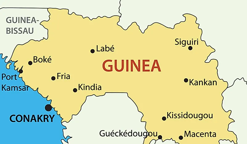
Guinea covers a land area of 94,918 square miles and it is the 77th largest country in the world. The country is situated on the western edge of the African continent, and archaeological evidence indicates that communities have made a home within Guinea's borders for a long period. Today, Guinea shares its land borders with six nations: Senegal, Sierra Leone, Ivory Coast, Guinea Bissau, Liberia, and Mali.
Senegal
Guinea's shortest border runs along the Guinea and Senegal and covers a length of roughly 226 miles on the northern edge of Guinea. The border between Senegal and Guinea was determined by the French as both nations formed part of French West Africa. There are several towns on the Guinean side of the border such as Mali and Koundara. The most notable town situated on the Senegalese side of the border is Kedougou.
The Relationship Between Guinea And Senegal
Guinea and Senegal have a common history as both countries were part of French West Africa. After both nations had attained their independence, they established formal ties. Despite the close ties and shared history between the two nations, several policies put in place by the Guinean government alienated it from Senegal. The relationship between the two states improved significantly in 1978 after diplomatic ties were reestablished. The Senegalese government is represented by an embassy situated in Conakry while an embassy located in Dakar represents the Guinean government.
Guinea Bissau
Guinea and Guinea Bissau are separated by a boundary that is approximately 262 miles long and is located on the western edge of Guinea. The Tommine River forms part of the boundary that separates Guinea and Guinea Bissau. There are many towns located on the Guinean side of the border such as Gaoual, Sangaredi, and Boke. Notable towns that exist on the Guinea Bissau side of the border include Gabu, Bafata, and Buba. The boundary was determined during the colonial era after the French, who had control of Guinea at the time, made an agreement with the Portuguese who had control of Guinea Bissau.
The Relationship Between Guinea And Guinea Bissau
The governments of Guinea and Guinea Bissau have put in place several strategies to foster bilateral ties between the two nations. One of the methods includes joint infrastructural development as there are several roads which link towns in Guinea to towns in Guinea Bissau. In Guinea Bissau, the Guinean government is represented by an embassy located in Bissau. On the other hand, the government of Guinea Bissau is represented by an embassy located in Conakry.
Mali
Mali and Guinea are separated by a border of roughly 660 miles long situated in the northern section of Guinea. The border also happens to be Guinea's longest land border. The French determined the border between the two nations since both Mali and Guinea were part of French West Africa. The Niger River is one of the rivers that cross the border between Mali and Guinea. Some of the towns located on the Guinean side of the border include Niagassola, Mandiana, and Siguiri.
The Relationship Between Mali And Guinea
The relationship between the two nations dates back to the colonial era as they were both French colonies. One of the main areas of cooperation between the Malian and Guinean governments is the utilization of the River Niger which flows through both nations. Mali and Guinea also cooperate on issues such as trade, economic development, and infrastructural development. The Malian government is represented by an embassy located in Conakry while an embassy within Bamako represents the Guinean government.
The Ivory Coast
Guinea and the Ivory Coast are separated by a boundary that is roughly 507 miles long and is situated in the eastern section of Guinea Bissau. The boundary was determined by the French during the colonial period as both nations were under French rule.
The Relationship Between Guinea And Ivory Coast
Official ties between the Ivory Coast and Guinea were re-established in 1978 a couple of years after they had broken down due to policies put in place by the Guinean government. One of the factors that contributed to positive ties between the two nations is the fact that several high profile individuals such as Sidya Touré had served in the governments of both countries. In 2005, the Guinean army had a conflict with Ivorian rebels along the border which resulted in the death of one Ivorian. The government of Guinea is represented by an embassy located in Abidjan while the government of the Ivory Coast is represented by an embassy in Conakry.
Sierra Leone
The border that separates Guinea and Sierra Leone is roughly 493 miles long and is located in the southern region of Guinea. Like the rest of Guinea's borders, the boundary with Sierra Leone was determined during the colonial era after the British, and the French agreed. Several rivers cross the Sierra Leone-Guinea border with some of the most well-known being the Mongo and the Bagbe Rivers.
The Relationship Between Sierra Leone And Guinea
Some of the aspects that Sierra Leone and Guinea cooperate on include infrastructure and infrastructural development. The government of Sierra Leone is represented by an embassy found in Conakry while an embassy in Freetown represents the government of Guinea.
Liberia
Liberia and Guinea are separated by a border that is roughly 367 miles long and situated on the southeastern side of Guinea. The French colonial government negotiated with Liberia on the position of the border. In Guinea, the Liberian government is represented by an embassy located in Conakry. In Liberia, the Guinean government is represented by an embassy in Monrovia.
The Security Of The Guinean Border
Due to the frequent regional instability, the government of Guinea has invested heavily in securing the borders. The government usually stations soldiers along the border to keep it safe.


