The Most Dangerous Volcanoes In The United States
Is there anything more unsettling than a mountain that might detonate? Some of these lava-, ash-, and gas-belching giants keep a running tally of destruction their neighbors can recite from memory. Others just sit there, dormant and patient, biding their time. Geologists will tell you the real question is not if but when. The U.S. Geological Survey's 2018 National Volcanic Threat Assessment sized up 161 volcanoes across the country and flagged 18 as a "very high threat" - a ranking that measures not which peak will blow next, but how much harm it could do to the people and property crowded around it. These are the ones at the top of the watchlist.
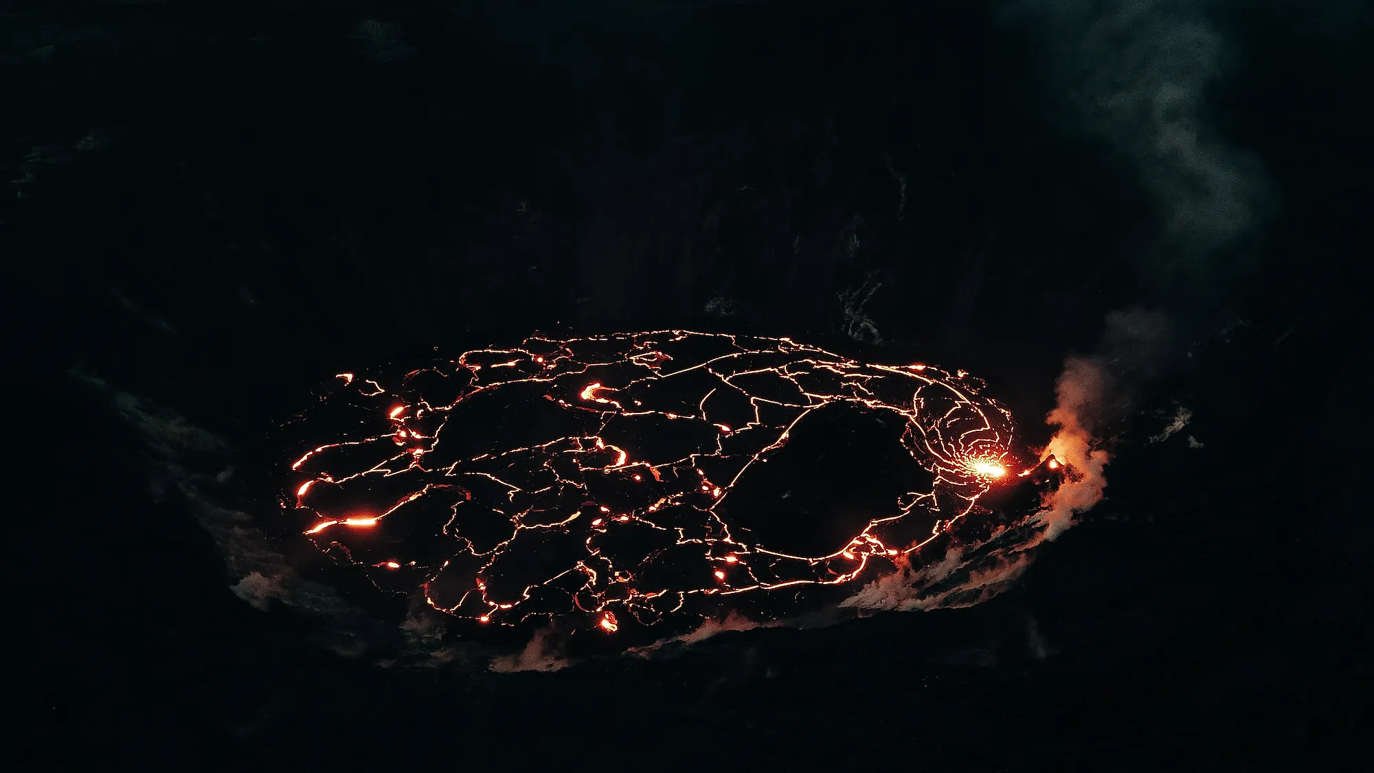
1. Kīlauea, Hawaii

Kīlauea is the baby of Hawai'i's volcanoes and also its most volatile - the single most active volcano on Earth and, by the USGS tally, the most dangerous in the United States. It erupted almost nonstop from 1983 to 2018, took a breather, then slipped back into near-constant activity in 2020. Its latest act is the showstopper: an episodic eruption that began in the Halema'uma'u crater on December 23, 2024, and is still running. This one does not ooze so much as perform. The summit fountains lava hundreds of feet into the air for a few hours, falls quiet for a week or two, then does it all over again. By the middle of 2026 it had cycled through roughly fifty of these episodes, the most ever recorded for an eruption of its kind, with some fountains clearing 1,000 feet. Subtle, it is not.
2. Mount St. Helens, Washington

Mount St. Helens is the rowdiest volcano in the Cascade Range and a charter member of the Ring of Fire, the horseshoe of seismic chaos that runs from the west coast of South America up to Alaska and the Aleutian Islands. It has spent its life swinging between violent tantrums and long sulks. The tantrum everyone remembers is May 18, 1980, when the entire north flank gave way and the mountain blew sideways. The blast flattened forests, killed 57 people (some of them miles from the crater), and threw up an ash cloud that circled the planet and dimmed the sky for hundreds of miles. In a single morning, the summit lost more than 1,300 feet of height. The most active volcano in the Cascades had made its point.
3. Mount Rainier, Washington

At 14,411 feet, Rainier is the giant of the Cascades, and it has been quietly active for somewhere between half a million and a million years. Past eruptions are thought to have hurled lava a thousand feet above an already towering summit. The most recent eruptive phase wound down about a thousand years ago, but the mountain never fully relaxes: parked in a subduction zone, it shrugs off around 20 small earthquakes a year. The truly frightening hazard, though, is not lava. It is lahars - fast, churning slurries of meltwater, mud, and shattered rock that can race down the river valleys toward the roughly 3.3 million people in the Seattle-Tacoma area, while other drainages feed the Columbia River system and another half-million residents in southwestern Washington and northwestern Oregon. The USGS takes the danger seriously enough to have wired the mountain with a dedicated lahar-detection network.
4. Redoubt Volcano, Alaska

Set deep in the Chigmit Mountains inside Lake Clark National Park and Preserve, this 10,197-foot Alaskan peak has a rap sheet. Redoubt blew in 1902, 1966, 1989-90, and again in 2009. Anything it does menaces the four villages and towns within 50 miles, plus the city of Anchorage, 108 miles to the northeast. Its most infamous stunt came during the 1989-90 run of 23 major explosions: a Boeing 747 carrying more than 200 people flew straight into the ash cloud, and all four engines flamed out. The jet dropped thousands of feet in eerie silence before the crew coaxed the engines back to life and limped into Anchorage. Volcanic ash, it turns out, is murder on jet turbines.
5. Mount Shasta, California

Shasta looms over far-northern California, and it is essentially the rebuilt heir to an older volcano that collapsed in a catastrophic landslide 300,000 to 500,000 years ago. The debris from that collapse spread across more than 170 square miles of Shasta Valley, making it one of the largest landslides known anywhere on Earth. Today's Shasta is the most voluminous volcano in the Cascades, and although its 14,163-foot summit wears a permanent coat of ice and snow, the towns living in its shadow (Weed, Mount Shasta City, and McCloud) know better than to take it lightly. The eruption record averages roughly one event every 600 to 800 years. Even in the quiet centuries, heavy rain regularly sends mudflows roaring down its stream channels, just to keep everyone honest.
6. Mount Hood, Oregon

Oregon's tallest peak is a postcard backdrop for Portland and a workhorse for the region's farms and ski resorts - and also a volcano with a temper. Hood has been blowing its lid off and on for half a million years, including two major eruptions in just the last 1,500. Its eruptions do not even need to be dramatic to cause trouble: the mudflows and debris they unleash can clog vital rivers for years afterward. The 1781 eruption dumped so much sediment into the Sandy River that the Lewis and Clark Expedition noticed the choked-up mess when they passed through in 1805-06. The last confirmed activity, in the mid-1800s, was minor, and Hood has played the serene scenic backdrop ever since. Fingers crossed it keeps the act up.
Honorable Mention: Yellowstone Supervolcano, Wyoming

No list of American volcanoes is complete without the elephant under the room. Yellowstone is not expected to erupt anytime soon, and scientists watch it obsessively, but its resume is genuinely terrifying. Its first cataclysmic eruption, 2.1 million years ago, buried an enormous stretch of the continent in ash and ranks among the largest eruptions ever known. Then, 640,000 years ago, another colossal blast caused the ground to collapse into a lake of lava, leaving behind a caldera that still measures roughly 30 by 45 miles even after later flows filled much of it in. Here is the reassuring part: Yellowstone has been volcanically quiet for about 70,000 years, shows no sign of a brewing eruption, and would almost certainly telegraph a big event with months of earthquakes first. Sleep tight.
The 18 Most Dangerous Volcanoes In The United States
Here is the full very-high-threat roster from the USGS assessment, ranked by overall threat score - a measure that combines each volcano's hazard potential with how many people and how much property sit within reach:
| Rank | Volcano in the "very high threat" category | U.S. state where the volcano is located |
|---|---|---|
|
1 |
Kīlauea |
Hawaii |
|
2 |
Mount St. Helens |
Washington |
|
3 |
Mount Rainier |
Washington |
|
4 |
Redoubt Volcano |
Alaska |
|
5 |
Mount Shasta |
California |
|
6 |
Mount Hood |
Oregon |
|
7 |
Three Sisters |
Oregon |
|
8 |
Akutan Island |
Alaska |
|
9 |
Makushin Volcano |
Alaska |
|
10 |
Mount Spurr |
Alaska |
|
11 |
Lassen Volcanic Center |
California |
|
12 |
Augustine Volcano |
Alaska |
|
13 |
Newberry Volcano |
Oregon |
|
14 |
Mount Baker |
Washington |
|
15 |
Glacier Peak |
Washington |
|
16 |
Mauna Loa |
Hawaii |
|
17 |
Crater Lake |
Oregon |
|
18 |
Long Valley Caldera |
California |
Keep One Eye On The Horizon
Volcanoes keep time on a scale that makes human history look like a coffee break, which is exactly what makes them so easy to underestimate. The 161 the USGS tracks have written their stories everywhere between ancient legend and last week's headlines, and the 18 at the top of the list are the ones with both the firepower and the audience to do real damage. Mauna Loa, sixteenth on the roster, made that point in November 2022 when it erupted for the first time since 1984. So admire these peaks, hike them, photograph them. Just keep an eye on the official warnings, and when the experts say go, do not argue.


