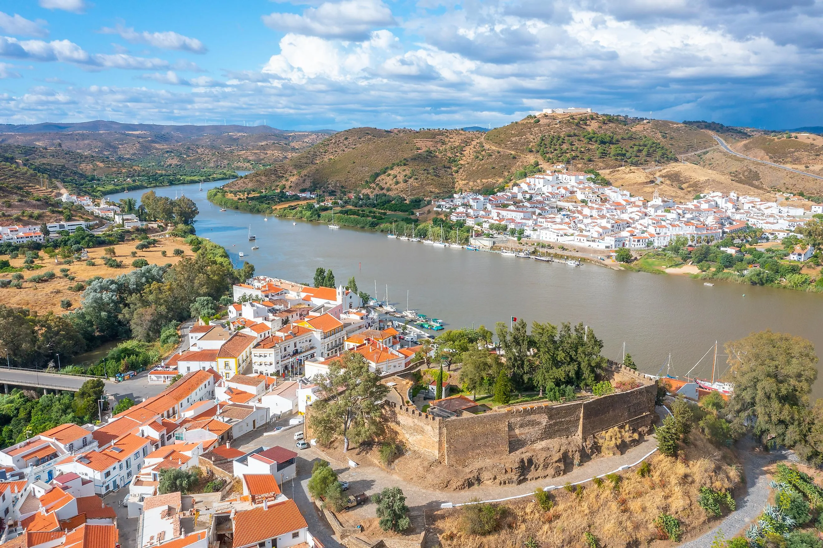
Guadiana River
The 508-mile-long Guadiana River is the Iberian Peninsula’s fourth-longest river that defines a long stretch of the boundary between Spain and Portugal. This international river flows through the south-central part of Spain from the east-to-west direction and then in the southern direction through southeastern Portugal, after which it forms the Spain-Portugal border. Between the Spanish town of Ayamonte and the Portuguese city of Vila Real de Santo António, the river finally drains into the Gulf of Cádiz, an arm of the Atlantic Ocean. Adventurous visitors can enjoy the world’s only cross-boundary zipline here that transports them from Alcoutim to Sanlucar on the Spanish portion of the Guadiana River. This exclusive opportunity to travel between the two nations in less than a minute is indeed a thrilling trip over the Guadiana River.
Course Of The Guadiana River

Although the exact source of the Guadiana River is disputed, it is believed that a spring located in Ojos del Guadiana in the Spanish municipality of Villarrubia de los Ojos, in Ciudad Real, Castilla-La Mancha province is the source of the Guadiana River. From its origin, the river flows from the east to west direction across the southern Iberian plain till the town of Badajoz, from where it begins its southward journey towards the Gulf of Cádiz. The Guadiana River has a total length of 508 miles, of which 359 miles fall within the Spanish territory, 87 miles within Portuguese territory, and 62 miles are shared between the two nations. The Guadiana River Basin encompasses an area of 26,152 sq. mi, 82% of which, i.e., about 21,407 sq. mi, is in Spain, whereas 17%, i.e., about 4,460 sq. mi, is in Portugal.

As the Guadiana River makes its way toward the Gulf of Cádiz, it twice marks the boundary between Spain and Portugal. The first is between Ribeira de Cuncos and River Cala, and the second is between River Chança till the Guadiana River’s mouth. However, the Guadiana River is not entirely used to define the boundary between the two nations. A part of the boundary that falls between the Táliga Ravine and Olivenza Ravine is a disputed segment that has been claimed ‘de jure’ by both nations and administered ‘de facto’ by Spain as a portion of the landlocked Spanish autonomous community of Extremadura. The Guadiana River is navigable for 42 miles from the Atlantic Ocean to Mértola. About 17km north of Mértola on the Guadiana River is the Pulo do Lobo waterfall, considered the highest waterfall in Southern Portugal.
Geography Of The Guadiana River
Many tributaries feed the Guadiana River. The left tributaries of the river include Upper Guadiana, Jabalón, Matachel, Chança, Azuer, Zujar, and Ardila Rivers. The right tributaries of the river include: Cigüela/Záncara, Bullaque, Estena, Degebe, and Ribeira do Vascao. The 133-mile-long Zujar River, which originates from the La Calaveruela hill in Spain’s Sierra Morena Mountain range, is the most prominent left tributary of the Guadiana River. Three autonomous Spanish communities, Castilla-La Mancha, Extremadura, and Andalusia, forming part of the Ciudad Real, Badajoz, and Huelva provinces, are crossed by the Guadiana River in Spain. The Portuguese regions of Algarve and Alentejo and the municipalities of Portalegre, Beja, Evora, and Faro are crossed by the Guadiana River in Portugal.

The transboundary Guadiana River Basin plays a vital role in the economic development of the entire region. Thanks to the region’s hot summer Mediterranean climate, the Guadiana River has high seasonal variability and a relatively low fluvial discharge in comparison to the other major rivers of the Iberian Peninsula. Although the river basin lies in such a semiarid region, the use of groundwater has helped to transform the basin’s rural areas into industrial and agricultural centers. However, the region is highly prone to droughts, and it is expected that in the near future, due to climate change, the frequency and intensity of such extreme events will increase in the Guadiana River Basin. Therefore, to deal with this problem, more than 30 dams have been constructed in the river basin, primarily for providing irrigation waters and generating hydroelectric power for the Badajoz province. Some massive reservoirs created by these dams include the Alqueva Reservoir, Garcia Sola Reservoir, Cijara Reservoir, El Vicario Reservoir, Orellana Reservoir, etc.
The Guadiana River finally empties into the Gulf of Cádiz and forms a salt marsh estuary between the Spanish town of Ayamonte and the Portuguese city of Vila Real de Santo António. This salt marsh estuary has a maximum width of 1,800 ft, while its depth ranges between 16 to 56 ft. The estuary experiences semi-diurnal tides that range from 2.6 to 11.5 ft. However, the upriver propagation of the tides is limited by falls located at Moinho dos Canais approximately 47 miles from the river’s mouth. The lower portions of the estuary feature nature reserves that cover a total area of 5,160 acres. Spain’s Marismas de Isla Cristina, and Portugal’s Castro Marim and Vila Real de Santo Antonio Marsh Natural Reserve, provide a highly valued nature conservation character to the entire region.
History Of The Guadiana River

The Guadiana River owes its name to the several civilizations that have taken place over centuries along its shores. The Romans called the river ‘Flumen Anas,’ which meant the “River of Ducks.” During the occupation of the region by the Moorish people, the Latin term ‘fluminus’ was replaced by its equivalent Arab term, ‘Wadi,’ and thus, the river came to be known as ‘Wadi Ana.’ In due course, when the Portuguese and Spanish settlers started inhabiting the region, the river was named ‘Ouadiana’ and later only ‘Odiana.’ From the 16th century onwards, the river came to be known as “Guadiana.”

It is believed that the first people to arrive in the regions along the Guadiana River were the Phoenicians from the Eastern Mediterranean. The Phoenicians were primarily merchants who brought different materials, like dyes, ceramics, wine, olive oil, seeds for crops, etc, to trade with the natives. The Phoenicians also established the Alcoutim and Mertola ports, as well as a fishing port at Vila Real de Santo Antonio. Almost 1000 years later, Julius Caesar conquered Algarve, and then in the 6th century AD, the Algarve region was occupied by the Visigoths. For over 200 years, the Visigoths ruled the area, and they used the Guadiana River for transportation and to construct fortified settlements along the river banks. However, in 711, the Moorish army occupied a significant portion of Spain and Portugal. The Moors administered the region for the next 600 years, and the Guadiana River was regularly used for inland transport and communication purposes. Nevertheless, by the end of the 13th century, with help from the Northern European crusaders, the Portuguese successfully defeated the Moors and regained their control over the region along the Guadiana River.
It is to be noted that in recent times, parts of the Guadiana River Basin have been severely impacted by groundwater extraction, territory fragmentation, contamination of water by harmful chemicals, intensive flow regulation, and loss of biodiversity. Over the years, several restoration initiatives have been taken to improve water infiltration processes, restore natural vegetation, and create ecological passageways throughout the Guadiana River Basin.