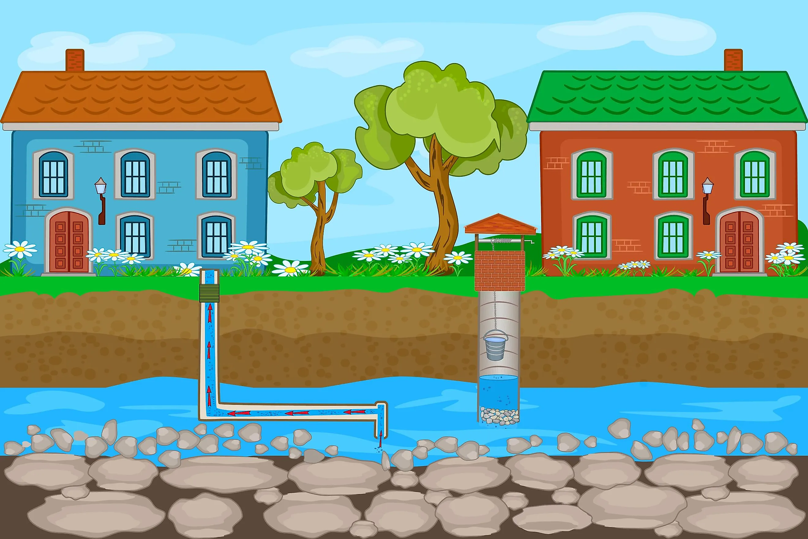
Groundwater And Aquifers
Water – the principal constituent of the Earth’s hydrosphere is vital for all known life forms. About 71% of the Earth’s surface is covered by water, primarily as ocean water, and with small portions occurring as surface and groundwater, glaciers and ice caps, and in the air as vapor, clouds, and precipitation. The circulation of water on the planet is crucial in controlling the life patterns of all living organisms and serves as a foundation for individual, societal, and ecological health. Groundwater refers to the freshwater present in the fractures of rock strata and the soil pore spaces beneath the Earth’s surface. Making up about 30% of all the readily available freshwater supply in the world, Groundwater is one of the most valuable resources on the planet that functions as a natural storage buffer against surface water shortages during periods of drought. Groundwater also flows within aquifers which are underground layers of permeable rocks or unconsolidated deposits that yield economically usable quantities of water to wells or springs.

It is estimated that groundwater accounts for more than half of the world’s drinking water supply, 40% of its irrigation water, and one-third of the water required for industrial activities. Via weathering and geomorphologic processes, groundwater also shapes the Earth and is essential for sustaining rivers, lakes, wetlands, and other ecological systems. However, at present times, this crucial life support system of the Blue Planet is under stress. The demand for groundwater supply is increasing daily due to rapid population growth, while anthropogenic climate change is imposing additional pressures on this water reserve and raising the chances of severe drought conditions.
Groundwater
Groundwater is mainly found in two regions of the Earth’s crust: the unsaturated zone and the saturated zone. Also called the vadose zone, the unsaturated zone is the subsurface region that extends from the ground surface to the water table. Here the soil and rocks are not fully filled with water; in other words, the pores within these rocks and soil contain air as well as water. As unsaturated zones always occur on the water table, the pressure head is less than atmospheric pressure, and a combination of surface adhesion and capillary action holds the water here. The vadose zone is further subdivided into three zones: the soil water zone, the intermediate vadose zone, and the capillary zone. Via capillary action, the water rises over the water table to fill the smaller zone above the saturated zone through a process called tension saturation.

Also called the phreatic zone, the saturated zone refers to the portion of an aquifer that is placed below the water table. In this zone, all pores and fractures are fully filled with water, and the water pressure here is usually much higher than the atmospheric pressure. The water table marks the boundary between the vadose and phreatic zones and represents the point where the water pressure is equal to the atmospheric pressure.
The hydrologic process by which water moves downwards from surface water to groundwater is called groundwater recharge. This recharge is the principal method by which groundwater enters an aquifer and takes place both naturally by rain, snow melt, and surface water sources and also via anthropogenic processes where rainwater or reclaimed water is routed to the subsurface. However, the rate of groundwater recharge is different for all aquifers, and this must be taken into account while pumping out water from a well. It is to be noted that the vadose zone often functions as the principal factor that controls the movement of water from the land surface to the aquifer. It also significantly affects the rate of aquifer recharge and is, therefore, vital for the management and use of groundwater.
Aquifer

Aquifers refer to the saturated subsurface region that yields a substantial quantity of groundwater to the springs and wells. Underground aquifers are made up of all types of porous rock materials, making them one of the Earth’s most important sources of freshwater. In contrast, aquitard refers to a zone within the Earth that prevents the movement of water from one aquifer to another. An aquitard is usually composed of layers of clay or non-porous rocks which have low hydraulic conductivity. In mountainous regions, the principal aquifers are of unconsolidated alluvium, usually composed of horizontal layers of different materials that are deposited by water. A completely impermeable aquitard is referred to as an aquiclude or aquifuge.

Generally, there are two major types of aquifers: confined and unconfined aquifers, with a small semi-confined layer in between the two. Unconfined aquifers are also known as phreatic or water table aquifers, as their upper layer is on the phreatic surface. Typically, at any given location, all shallow aquifers are unconfined, which means that they do not have an impervious rock (confining) layer between them and the surface. In contrast, confined aquifers are those that are overlain by a confining layer, which is thought to provide the aquifer some protection from surface contamination. The groundwater in confined aquifers is usually under tremendous pressure. This extreme pressure causes water to rise above the aquifer level in an artesian well. An aquifer test is performed to differentiate confined aquifers from the unconfined ones. Confined aquifers usually have lower storativity values in comparison to unconfined aquifers that have high storativity values.
Water Movement In Aquifers

Both ground and surface water are a part of the hydrologic cycle and are, therefore, always in constant movement above or below the earth’s surface. In most cases, groundwater originates as precipitation (rain and snow) that penetrates the ground surface and seeps down to the water table, the depth of which varies from location to location. Due to capillary forces that result from the adhesion of water molecules to subsurface solids and the cohesion of water molecules to one another, the groundwater rises a small distance into the soil pores above the water table. A significant number of void spaces in the rocks and unconsolidated materials below the water table are filled with water. The amount of water an aquifer can hold greatly depends on the volume of the underground rock or unconsolidated materials and the size, and the number of pores and fractures that are filled with water. Driven by potential energy, the groundwater flows through these pore spaces at extremely slow velocities. This groundwater from the aquifer then resurfaces from springs and wells.
Threats To Aquifers

It is to be noted that groundwater becomes depleted if it is used at a comparatively faster rate than it can replenish itself. Currently, in keeping pace with the rapidly growing human population, there has been a rise in industries with increased use of chemicals and various other harmful contaminants that eventually find their way into the groundwater. Groundwater pollution occurs from various sources, like the use of farm chemicals like fertilizers, pesticides, and herbicides that seep through the porous ground and contaminates the groundwater; leaking sewers; effluent from wastewater treatment plants; landfill leachate; etc. The consumption of this polluted or contaminated groundwater causes public health hazards. Moreover, with increasing population growth, aquifers are also being rapidly depleted by overuse or over-abstraction. When too much groundwater is pumped out from underground, it can lead to groundwater-related subsidence, causing a drop in the ground surface.
In addition, coastal aquifers around the world have been witnessing saltwater intrusion, which many anthropogenic factors like climate change and sea level rise can worsen. This mixing of saline seawater with the coastal groundwater renders it unfit for use. Therefore, it is necessary to examine how groundwater storage might change in response to both climate-driven and other anthropogenic effects. Proper groundwater management is the need of the hour, and the competent authorities must frame laws and regulations that regulate access to groundwater sources as well as control human activities that can impact groundwater quality.