7 Most Beautiful Rivers in North Carolina
North Carolina, the Tar Heel State, is home to some of the most beautiful and dynamic rivers in the United States. From the rolling hills of the Appalachian Mountains to the sandy coastline, this southeastern state offers an array of expansive waterways with stunning views and valuable resources. Majestic whitewater rapids run in parallel with tranquil lakeside trails, proving that North Carolina's many rivers provide opportunities for exploration and adventure that all ages can enjoy year-round. Whether you prefer fishing, kayaking, rafting, or a peaceful stroll along its banks each river offers something unique.
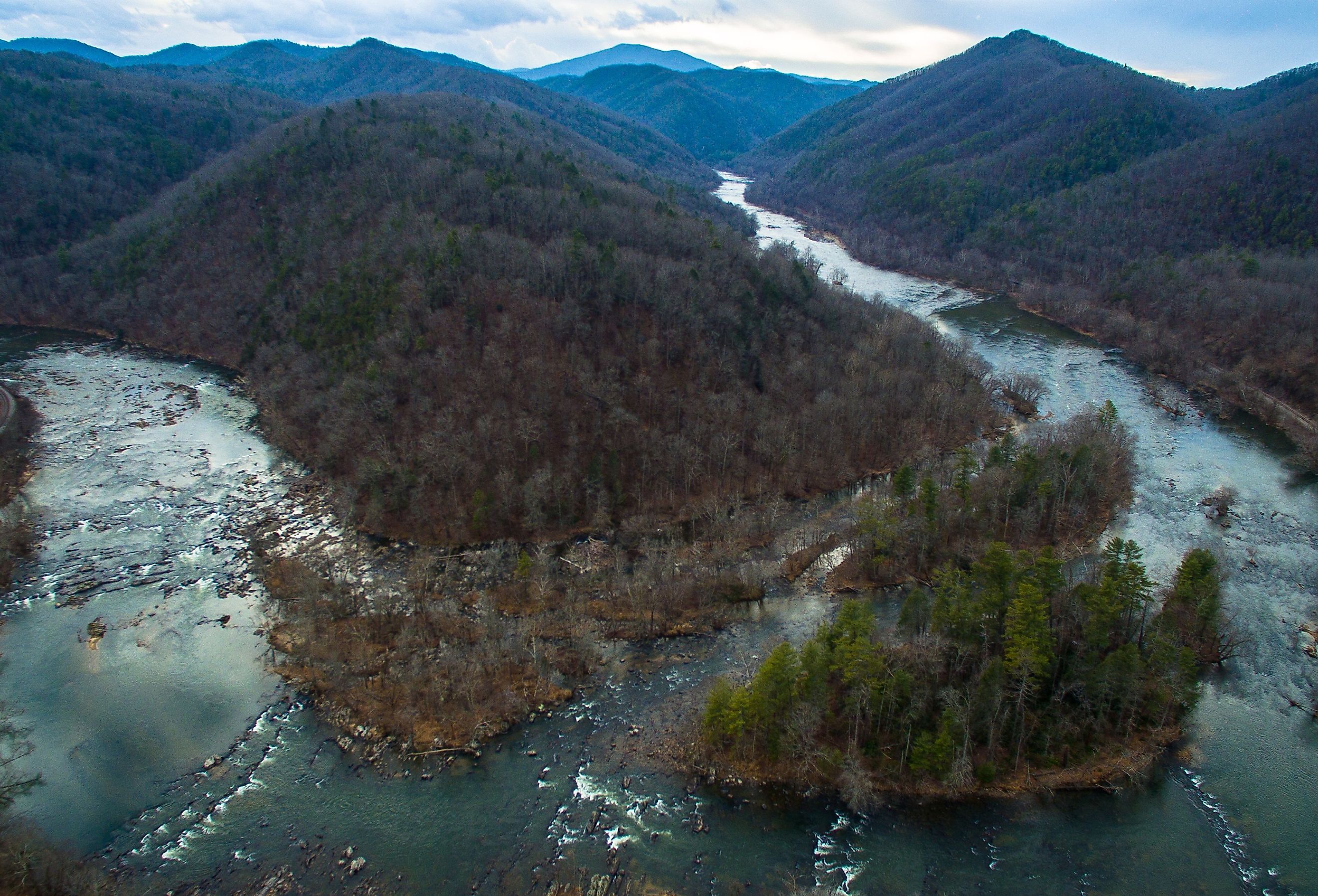
French Broad River

The French Broad River is an iconic river in North Carolina. It stretches over 200 miles from Rosman, North Carolina, to the Tennessee-North Carolina border. It passes through the colorful cities and towns of Asheville, Marshall, Hot Springs, and Etowah along its route. The river has a rich history that dates back to the pre-American settlement. The Cherokee people lived near it for centuries before colonization. Known as one of America's oldest rivers, William Bartram recorded the French Broad River in journals as he explored western North Carolina during the 1700s. The French Broad originally served as part of a significant waterway network connecting southern Tennessee and present-day North Carolina to Georgia before human development separated them into distinct bodies of water.
In the course of its 218-mile journey, it flows through several rural areas and small communities until it reaches its final destination at Douglas Lake on the Tennessee/North Carolina state line. Along its banks are majestic mountain views, old-growth forests, rolling hillsides, quartz formations, wildflower meadows, rapids, gorges, trout hatcheries, and plenty of recreational opportunities for river adventurers.
Today the French Broad River is an essential source for more than 1 million residents in western North Carolina, providing drinking water to several local communities such as the Asheville city county area. It is also home to wildlife like endangered freshwater mussels and numerous fish species, including bass and catfish, and turtles and reptiles like salamanders. From its humble beginnings with American settlers in pre-colonial times, the French Broad River remains one of Western North Caroline's most cherished treasures and will remain so for years to come.
The Dan River

The Dan River is a waterway that runs through North Carolina and connects to the larger Roanoke River. It flows from Stone Mountain State Park in the Rocky Knob region and traverses through Stokes, Rockingham, Caswell, and Person counties before reaching Kerr Lake. The river has a long history in the area. Draining over 1,400 square miles of land, it was an essential resource for Native American tribes as early as 1701. Colonists relied on it for transportation and power from mills during the 1700s to 1800s. Later, it also provided energy to many industries, such as paper-producing factories, iron foundries, and cotton mills.
The Dan River offers diverse habitats throughout its course, including wetlands, forested areas, and large pools of open water, which support various aquatic life. Historically known for its rich trout fishing opportunities, the river is now home to several species of fish, including smallmouth bass and striped bass. Among wildlife along its banks, you can find otters, beavers, mink, and white-tailed deer.
The Dan River provides recreational opportunities for visitors throughout all four seasons. The most popular activities include canoeing or kayaking down its peaceful waters while enjoying stunning views of rolling countryside and dense forests along the banks; fishing along its depths; hiking trails; camping spots; or swimming at some of its more accessible points.
Catawba River

The Catawba River runs through western North Carolina, originating in the Blue Ridge Mountains and meandering for more than 220 miles before emptying into the Piedmont region. As one of North Carolina's longest rivers, the Catawba River has been a vital resource for Native Americans living in its watershed. Tribes such as the Catawba people used it for fishing and trading goods, while later settlers established farms along its winding banks. Today, it offers hydroelectric production and recreational opportunities, including whitewater rafting and fishing.
Its watershed covers ten counties, including Cleveland County—home to Lake Norman—which provides drinking water to Charlotte-Mecklenburg County. The river flows through several protected areas, such as the Uwharrie National Forest and Lake Wylie, which formed when locals built a dam on its northern end in 1904. In recent decades many industries have taken advantage of its vast resources, from livestock feed production to electric power generation, as well as several water treatment facilities close to its shores.
Fortunately, with heightened environmental awareness, visitors can still expect to see wildlife along its course, including bobcats, osprey, and heron. Today the Catawba River serves multiple purposes; providing drinking water to over 2 million people through local distribution plants while also offering recreational activities like boating and fly fishing that draws outside visitors year-round. It continues to be an essential part of daily life in North Carolina culture, with significant importance placed on preserving this vital resource long into the future.
New River

The New River is a significant waterway in North Carolina and is one of the oldest rivers in the United States, estimated to be between 10 and 360 million years old. The river runs for approximately 320 miles, beginning near the Virginia state line before turning north and meandering to its end in the Atlantic Ocean just south of Cape Lookout National Seashore. It is one of the few rivers in the world to flow from south to north.
Historically, it has been an important transportation route for both Native Americans and Europeans, providing food sources and fertile agricultural land. In recent times, it was integral to much 19th-century industry through its course alongside inland waterways, which made way for coal, iron ore, timber, textiles, and other goods to ship from places like Abbottsburg to Wilmington.
Geographically speaking, the New River flows through several different localities and provides direct access to many major lakes. It is also home to several iconic wildlife species, such as eagles, wild boars, and several varieties of fish. In addition, visitors can take advantage of various activities along its banks, such as fishing or canoeing on calm waters.
Cheoah River

The Cheoah River is a 20-mile river flowing through the western North Carolina Appalachian Mountains in two sections, each with its own unique features. Located in Graham and Swain Counties, the Cheoah originates in the southern ridge of Sandy Mush Mountains via two streams. The upper section includes challenging whitewater centered around the artificial lake, Santeetlah Lake. The upper section also features power generation in the form of a hydroelectric dam built between 1916-1919 by the Power and Engineering Group of Alcoa.
The lower section of the Cheoah meanders from Calderwood Dam, which impounds Chilhowee Lake, to Fontana Dam, where it eventually empties into the Little Tennessee River. This stretch is excellent for recreational fishing, swimming, tubing, and kayaking. Adjacent to this area is some of North Carolina's most popular sites, such as Joyce Kilmer Memorial Forest and Cherohala Skyway National Scenic Byway. The Cheoah River has drawn attention due to its importance in conservation efforts over the past few decades with multiple national organizations actively taking part in preserving its ecosystem, including trout species populations, mussel populations, and riparian vegetation areas along its banks.
Little Tennessee River

The Little Tennessee River originates in the Appalachian Mountains of North Carolina. It flows southward through the western part of the state to its confluence with the Hiwassee River near Lenoir. It spans 135 miles, with a total drainage area of over 2,600 square miles. The river is part of the more extensive Tennessee-Tombigbee Waterway system.
The first European settlers along the river's banks were Scots-Irish people who arrived in the late 1700s and early 1800s. During this period, Cherokee villages existed along the upper Little Tennessee River. After miners discovered gold in north Georgia, settlers began to move into Cherokee territory as part of Andrew Jackson's Indian Removal Act of 1830. This migration led to violence between Native American tribes and white settlers, culminating in the devastating Trail of Tears, where the government forcibly relocated thousands of Cherokees westward.
The Little Tennessee River played an important role during both the Civil War and World Wars I and II due to its navigable nature, providing transportation routes for military troops and supplies throughout these conflicts. The area around today's Fontana Dam was one of the most heavily traveled areas on rivers up and down the Eastern Seaboard during World War II due to aluminum production occurring nearby at Alcoa Aluminum Company.
Today there are many dams located on different sections of this river that provide hydroelectric power, navigation control, recreation opportunities like fishing and boating, and water supply for local towns along its path. Commercial logging is still operational in some areas along its banks. Still, modern-day regulation has helped reduce pollution from logging activities by requiring unique harvesting methods designed to minimize impacts on streams or riparian habitats.
Tuckasegee River

The Tuckasegee River is a 60-mile river in western North Carolina. It is one of the state's most historic and scenic rivers and is popular among kayakers, canoeists, anglers, and outdoors enthusiasts. The river rises near Cashiers Lake in Jackson County and winds through North Carolina's rugged terrain before emptying into Fontana Lake in Swain County. It passes through small towns such as Cullowhee and Webster and crosses several mountain ranges, including the Great Smoky Mountains National Park.
Throughout history, this river has been essential for Native Americans to access trade routes and navigable waterways. Early settlers also used it as an efficient means of transport when road infrastructure was lacking. Today, many visitors flock to the Tuckasegee River for its recreational uses, such as whitewater rafting or fishing trips down its 15 miles of public access waters.
The Tuckasegee River corridor contains numerous valuable natural resources that contribute to the area's biodiversity. These include over 100 species of fish, mussels, crayfish, reptiles, amphibians, and numerous rare plants. Additionally, it serves as a habitat for countless bird species, including bluebirds, wood ducks, and herons which often make their homes near marshes located off the riverbanks. The Tuckasegee River has served as an indispensable resource throughout history for both its native inhabitants as well as settlers seeking new lands to explore.
North Carolina is truly a paradise for those who love rivers and the myriad activities they offer. For sports like fishing, whitewater rafting, canoeing, kayaking, and more, these rivers have served their human and wild neighbors for countless millennia. Whether it is the majestic French Broad River winding through the Appalachians, the Catawba River running through Charlotte, or the scenic Cheoah and Little Tennessee Rivers merging in North Carolina's far western corner, each river offers unique experiences with characteristics unlike any other.


