Oklahoma Panhandle
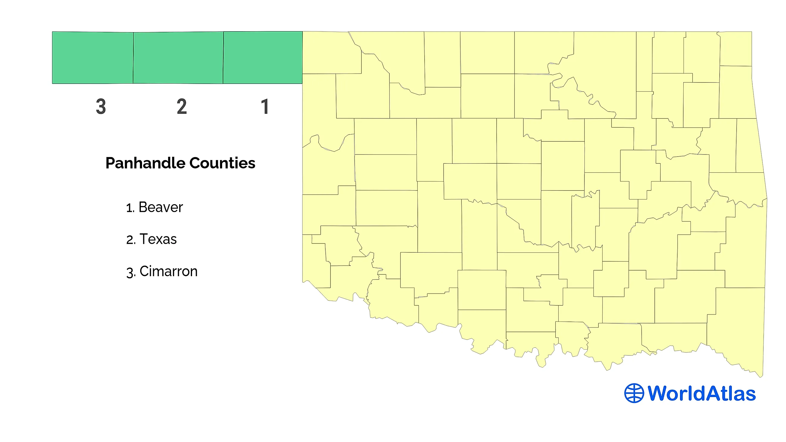
The Oklahoma Panhandle constitutes the northwestern region of Oklahoma, United States. It juts out from the main body of the state in the state’s extreme northwestern corner. The region consists of three counties: Beaver County, Texas County and the Cimarron County. The Oklahoma Panhandle was formerly referred to by various names such as the No Man’s Land, the Public Land Strip, the Neutral Strip, and the Cimarron Territory.

Geography
The Oklahoma Panhandle is 267 km in length and 55 km in width. It is bordered to the north by Colorado and Kansas, to the south by Texas, to the west by New Mexico, and to the east by the main land mass of the state of Oklahoma. The total land area of the Oklahoma Panhandle is 14,730 sq. km, which makes up 8.28% of the state’s total area. Located in the Cimarron County is the highest peak in the state - Black Mesa, which reaches to an elevation of 1,516 meters.

The terrain of the Oklahoma Panhandle is characterized by flat plains and semi-badlands. The area occupies nearly all of the High Plains, which constitutes the southern portion of the Great Plains, and generally consist of flat grassland. The Oklahoma Panhandle is home to the Beaver Dunes State Park and the Optima National Wildlife Refuge.
History

The story of the Oklahoma Panhandle begins with the Compromise of 1850, in which Texas, then an independent country, ceded the disputed territory to the US government. In 1854, this land was apportioned amongst the new territories of New Mexico, Nebraska, and Kansas, except for a rectangular-shaped piece of land controlled by the federal government. This was how the Oklahoma Panhandle was formed. Between 1850 and 1890, this land was not attached to any state or territory, and was referred to on maps as “Public Land” or “Public Land Strip”. In the 1880s, it was popularly known as “No Man’s Land”.
Between 1850 and 1875, this No Man’s Land was controlled by Native American Comanche bands and their allies. In the 1860s, some New Mexico sheep herders began settling in the region. They were followed by New Mexican buffalo hunters in the 1880s. After 1875, the Comanche and other Native Americans were moved out of the Oklahoma Panhandle onto reservations, and the buffalo herds of the area were all but gone. At this point, Texas cattlemen began moving into the region. From 1885 onward, many communities began to sprout up in the region. This was a time when there was no state or federal law in force in the Oklahoma Panhandle. Thus, local communities had to organize their own social services and law enforcement.
In 1890, the No Man’s Land was given to Oklahoma Territory. In 1901, the first railroad to run through the region was built, triggering economic growth. From this point on, the economy and settlement patterns in the Oklahoma Panhandle would revolve around the railroads. In 1907, Oklahoma, including the panhandle, became a state. Economic conditions in the region remained good until the 1930s, when the Great Depression, coupled with drought, turned the Oklahoma Panhandle into what was known as the Dust Bowl.
The Oklahoma Panhandle Today

The last census, conducted in 2010, showed that more than 28,000 people lived in the Oklahoma Panhandle, making it very thinly populated compared to the rest of the state. In the last decade, however, the panhandle, or more specifically the Texas County, has been witness to a significant population surge, with a large number of Hispanic families moving into the area. This population surge has put a strain on the region’s social infrastructure, and may compromise the region’s economic well-being.