This Pacific Coast Scenic Byway Is The Road Trip Of A Lifetime
Have you thought about exploring the West Coast of the United States, but want to avoid the kinds of over-crowded, overdeveloped destinations you often find in California?
If you are willing to go a little further north, due in large part to its rugged, jagged geography and huge amount of state/national parklands protecting the wonderful natural landscapes that make it up, Oregon's coastline might be just what you are looking for. It is so beautiful, in fact, that the entire length of the state's oceanside Highway 101 has been deemed the "Pacific Coast Scenic Byway," a 363-mile stretch of road that is best explored over the course of several days.
We will split this byway up into four distinct sections, going north to south, and recommend some of the top stops to visit along the way. From towering ocean stacks to lush rainforests, historic lighthouses, cozy towns, and more, see which spots might catch your interest the next time you're in the area.
The Northern Tip: From Historic Astoria to Tillamook

The far northern stretch of Oregon’s Pacific Coast Scenic Byway, from Astoria to Tillamook, is rich in both history and verdant coastal scenery. The byway itself commences in Astoria, a city that was founded in 1811, the oldest American settlement west of the Rockies. Its waterfront reflects a long history of fishing and trade, marked by landmarks like the Astoria Column and the Columbia River Maritime Museum. Grab a fresh meal from one of many seafood restaurants in the area, perhaps stay the night in a hotel downtown, and use any of the other modern amenities here before embarking.

About 25 miles south of town on Highway 101, the cliffs of Tillamook Head make for a perfect first stop once you start the trip, hosting the site of the Tillamook Rock Lighthouse. Completed in 1881 and perched on a small basalt island, this decommissioned lighthouse, known as “Terrible Tilly,” once guided ships through some of the Pacific Ocean's roughest weather.

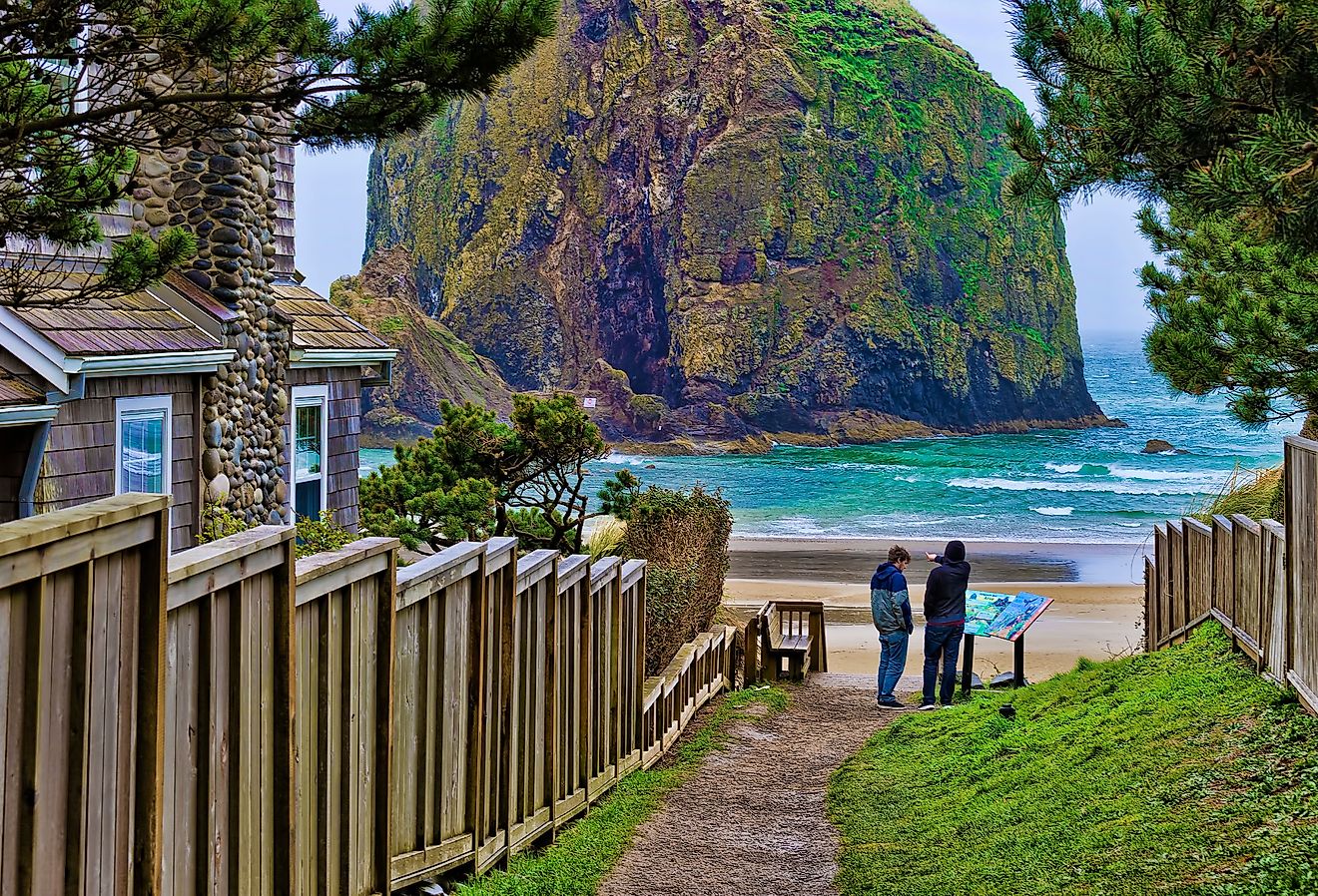
Further south along the coast lies one of Oregon's most iconic oceanscapes: Cannon Beach. This highly photogenic beach attracts visitors with its tidal ecosystems and the massive Haystack Rock, a towering, protected nesting area for seabirds. The adjacent town maintains a very compact, walkable center with charming businesses such as eclectic art galleries, small inns, and restaurants that cater to travelers following the byway. Ecola State Park is another locale worth a visit, filled with quiet coastal meadows and high points above the ocean that are perfect to hang out at during a sunset.

Another 40 miles down, near the end of this first quarter of the route, lies Tillamook, a community known for its dairy industry and down-to-earth, countryside beauty. Both the Tillamook Creamery and the Tillamook Air Museum provide insight into the town’s agricultural and military functions, two sides of local history that are equally interesting. If you're down for a short hike, too, definitely make a point of stopping at nearby Munson Creek Falls, which tumbles 319 feet through a temperate rainforest of Sitka spruce. It is notably the tallest waterfall in Oregon’s Coast Range.
Explore Some of Oregon's Most Interesting Geological Landmarks

The road from Oretown to Yachats follows a rugged and varied coastline defined by basalt cliffs and small fishing towns. Near Oretown, the route heads toward Cascade Head, a UNESCO Biosphere Reserve where coastal rainforest meets open grassland above the Pacific. The headland supports rare plant communities and provides broad views of the Salmon River estuary below, perfect for nature lovers of all kinds.

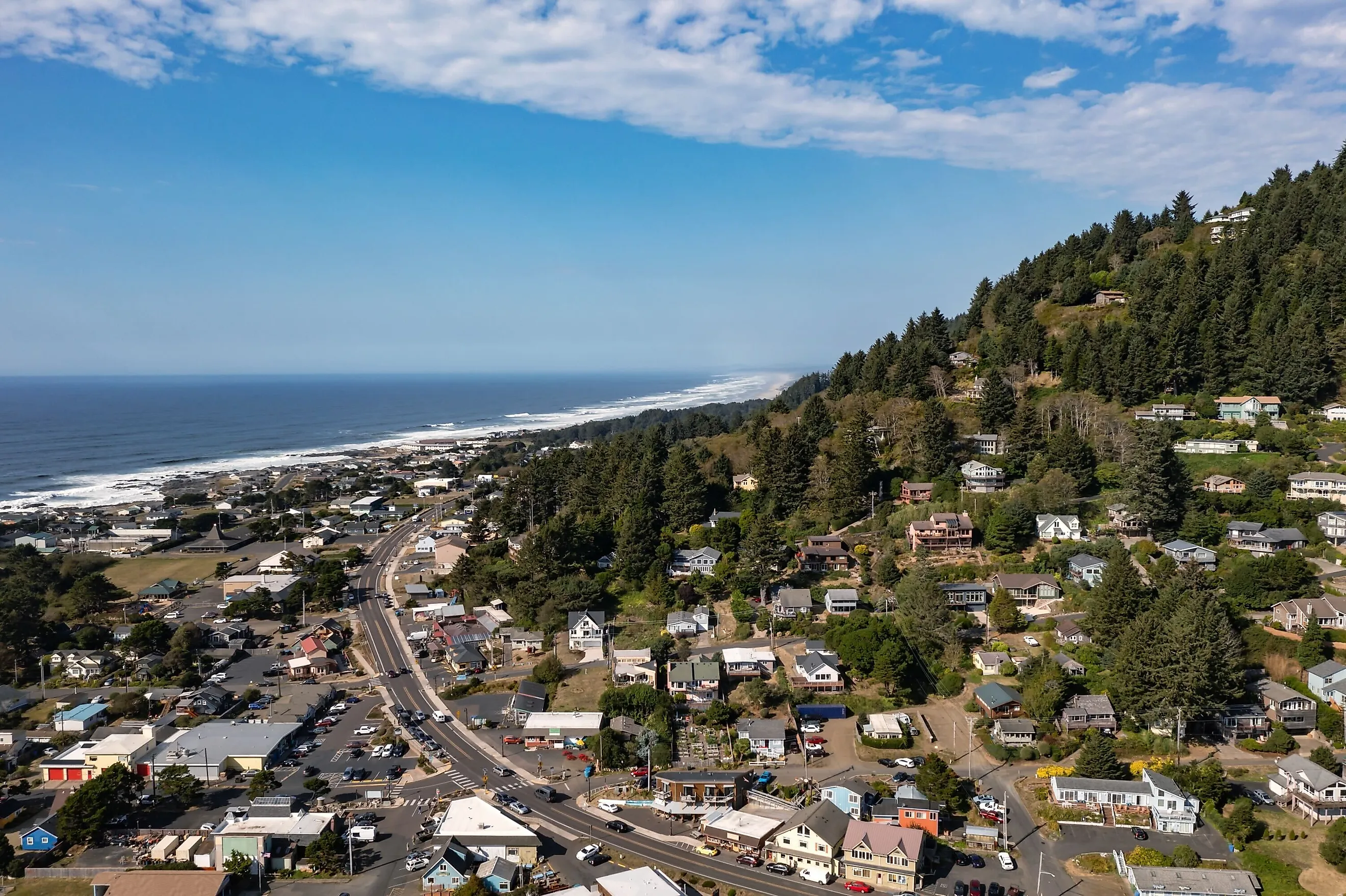
Next, the byway passes Lincoln City and Depoe Bay before reaching Devil's Punchbowl State Natural Area. This collapsed sea cave fills dramatically with ocean surf during high tide, and doubles as an ideal vantage point for whale watching. Just beyond lies Yaquina Head Lighthouse near Newport, the tallest lighthouse in the state. Erected in 1873, it continues to operate and stands within a protected natural area known for its lively tide pools and nesting seabirds.

The city of Newport itself is a good spot to spend a day in, or even spend the night, sitting roughly halfway down the byway. It functions as a sort of central hub on the Oregon Coast, balancing its working harbor with renowned marine research institutions like the Oregon Coast Aquarium and the Hatfield Marine Science Center, both of which you can visit.

Another hour's drive south of town, the highway skirts sheer cliffs until reaching the Sea Lion Caves, a vast oceanside grotto housing a year-round colony of Steller sea lions and serving as one of the most visited tourist attractions in all of the West Coast. If the sea lions aren't impressive enough, it is also considered America's largest naturally formed basalt sea cave, being as wide as an average football field and standing 12 stories high!
Sand Dunes As Far as the Eye Can See and More Lighthouses

This next portion of the Pacific Coast Scenic Byway, between Florence and Bandon, does a good job at highlighting Oregon’s continuously shifting coastal landscapes, where dunes, headlands, and rocky shores converge to make up some of the state's best outdoor recreational areas.
South of the small city of Florence, the Oregon Dunes National Recreation Area extends for nearly 40 miles, forming one of the largest stretches of temperate coastal sand dunes in the entire world! Some dunes here rise over 500 feet, with the area also supporting a mix of hiking, off-highway vehicle routes, and quiet lakeside campgrounds tucked among coastal pines.

Farther south near Winchester Bay, the Umpqua River Lighthouse stands above the mouth of the waterway. Built in 1894, it impressively remains active and houses a modern museum detailing regional maritime history. Near the lighthouse is the Whale Watching Station and Viewpoint, another prime location for observing migrating gray whales during winter and spring.

Approaching Coos Bay, the scenery transitions from dunes to more heavily forested estuaries. Coos Bay is the largest coastal city in the state, being home to around 16,000 residents. As with many settlements in this region, it has long been tied to the timber and shipping industries, but now contains a few more modern draws along with them, like a distinct waterfront district with its fun Coos History Museum.
Just south of the city, the Pacific Coast Scenic Byway continues toward another top-tier greenspace, Cape Arago State Park, where steep cliffs overlook tide pools and offshore sea lion colonies. Trails here link to nearby Sunset Bay and Shore Acres State Parks, offering yet another idyllic set of spots to catch panoramic coastal views, as well as boasting professionally maintained gardens established on a former estate located within.
Parks, Campy Roadside Attractions, and other Sights and Sounds Near the California Border

The southernmost quarter of the route traces what is perhaps the state’s most rugged shoreline. It starts around Cape Blanco, Oregon’s westernmost point and the second most westernmost point in the contiguous United States, a spot that rises more than 200 feet above the Pacific. The lighthouse here, completed in 1870, is the oldest continuously operating light on the Oregon Coast, too. Moreover, the surrounding landscape is part of Cape Blanco State Park, where windswept bluffs and a web of footpaths lead to historic sites such as the Hughes House and vistas overlooking the Sixes River mouth.

Nearby lies Port Orford, the oldest platted town on the coast. Its unique dolly dock, where boats are hoisted in and out of the water by crane, reflects the challenging, yet scenic conditions of this exposed shoreline. Explore this hardy little town for yourself at the Battle Rock Wayside Park, which marks the site of various early conflicts between settlers and Indigenous peoples, and comes with sweeping coastal views.
Farther down the byway, you'll encounter the Prehistoric Gardens, an old school roadside attraction dating back to 1955, set in a lush swathe of coastal rainforest. It's mostly appealing to kids and dinosaur lovers who don't mind a little campiness, with its "life-sized" dinosaur sculptures standing among the region's ferns and moss-covered trees. If you do decide to pass by this odd landmark, the area still offers the Cape Sebastian State Scenic Corridor about 20 miles south, easily one of the coast’s most picturesque trails. This 1.5-mile walk boasts a highly varied set of natural landmarks, including waterfalls, old-growth forests, oceanside vistas, and more.
The Pacific Coast Scenic Byway concludes at the California border near the city of Brookings, a community shaped by the Chetco River that features some of the mildest coastal climate in Oregon. With its botanical gardens, variety of beaches, and nearby redwood groves, Brookings marks a natural transition from this Pacific Northwest state's rocky headlands to the forested coast of northern California, with the Crissey Field State Recreation Site marking the crossing point.
Check Out This Peaceful Alternative to California's Busier Coastal Routes
Whether your aim is to hike some of the most picturesque spots along the west coast, or simply want to embark on a breezy drive down this wonderful stretch of highway, stopping periodically at easily accessible roadside attractions, the Pacific Coast Scenic Byway is a wonderful alternative to many of the more well-known routes in both the broader Pacific Northwest and on California's extensive oceanside border. You can also simply add this byway to a greater journey covering both Washington and California, too, extending an already incredible road trip to include a plethora of world-class landmarks in the Oregon portion of the journey.
Regardless of how you decide to travel it, you really can't go wrong with any of the above recommended destinations. You will, however, likely discover for yourself dozens of extra cool things to see and do along the way, so be open to surprises around every corner.