8 Great Road Trips to Take in Kentucky
The best way to see Kentucky is not from a single town but from between them. The Country Music Highway links the hometowns of Loretta Lynn, The Judds, Chris Stapleton, Ricky Skaggs, and Dwight Yoakam. The Lincoln Heritage Scenic Highway connects the towns Abraham Lincoln knew before the White House. The Old Frankfort Pike runs through Bluegrass horse-farm country, and the Great River Road delivers the catfish plates that double as local currency. Eight drives, every corner of the state, all worth pacing rather than rushing.
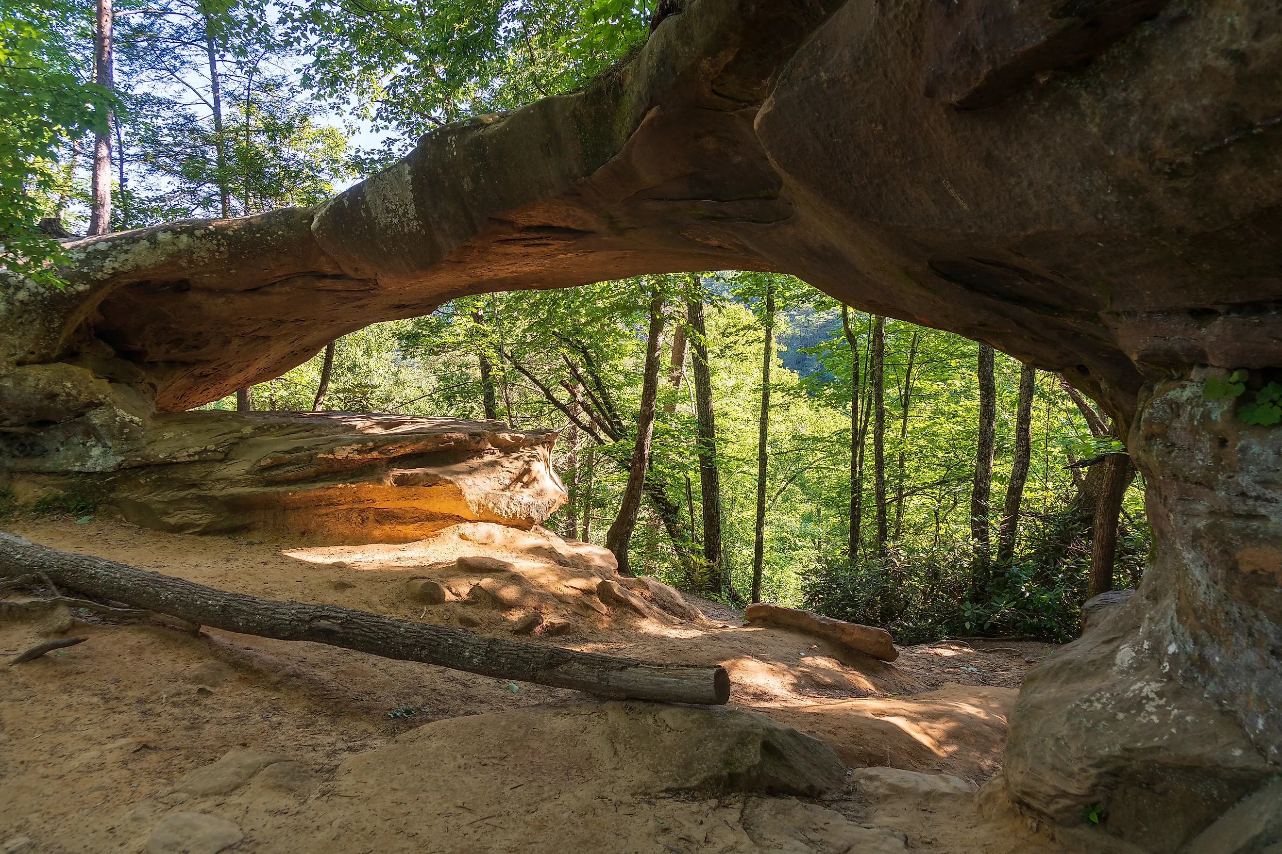
The Red River Gorge Scenic Byway

Cruise through mostly two-lane highways with frequent curves, following stretches that parallel the 97-mile Red River. A 19.4-mile segment of the river was designated National Wild and Scenic in 1993 (from the KY 746 bridge to the mouth of Schoolhouse Branch); it is the only such designation in Kentucky. The river flows through a gorge holding more than 100 natural sandstone arches. Expect moderate elevation changes; the route runs through rolling hills rather than craggy mountaintops, but the climbs are enough to keep the drive lively. The Red River Gorge Scenic Byway is approximately 46 miles and worth at least an hour with stops at the points of interest along the way. Begin in Stanton on State Highway 11 and head east. Don't proceed straight on State Highway 11, though.

Instead, make a loop close to the Red River using State Highways 77 and 715, then later rejoin State Highway 11 to its endpoint in Zachariah, an unincorporated community in Wolfe County. Keep an eye out for Nada Tunnel, a 900-foot hand-carved one-way passage through solid sandstone. Slightly ahead is the Martins Fork Parking Area, a good spot to pull over and stretch on the trails nearby.
Woodlands Trace National Scenic Byway

The Woodlands Trace National Scenic Byway is a forested drive through the Land Between the Lakes National Recreation Area, which offers 300 miles of undeveloped shoreline for paddlers and 500 miles of trails. "The Trace," as locals call it, runs north-south for 43 miles between Grand Rivers, Kentucky, and Dover, Tennessee, a river town typically associated with the Fort Donelson National Battlefield. Roughly half the byway falls inside Kentucky, with the Cedar Pond Picnic Area sitting near the state line just before the Tennessee section begins.
This is an easy drive through rolling terrain with frequent pull-offs at the developed interpretive facilities. Spring brings blossoming trees and flowers; summer adds a green canopy; fall delivers heavy foliage; and winter opens up the forest views. You'll mostly drive a paved two-lane highway following the ridge between Kentucky Lake and Lake Barkley, with gentle bends that follow the contour of the lake-lined ridges. Stop at the Golden Pond Planetarium and Observatory, which has a room of historical information on the Land Between the Lakes and a gift shop with toys, t-shirts, and books.
Wilderness Road Heritage Highway

For mountain terrain and views of Appalachian ridges, the Wilderness Road Heritage Highway is the drive. This is also a historic route that played a crucial role in westward settlement and during the Civil War. The route begins in Middlesboro near the Kentucky-Tennessee border. It follows State Highway 229 through Pineville, Barbourville, and London before picking up U.S. Highway 25 north. From there it passes through Renfro Valley, Kentucky's Country Music Capital, and finally Berea, the state's arts and crafts hub.
You'll be driving through Appalachian foothills and ridges with rolling terrain and winding roads, especially early in the drive near the Cumberland Gap and Middlesboro. The mountains create continuous bends and elevation changes through this section. Cumberland Gap National Historical Park has forested vistas and historic paths to explore. Further on, in London, Levi-Jackson State Park combines a short history walk, a worthwhile trail, and the Old McHargue's Mill collection of millstones.
Old Frankfort Pike Historic and Scenic Byway

This is classic Bluegrass countryside: rolling hills, limestone fences, and horse farms in pastures stretching to the horizon. The Old Frankfort Pike Historic and Scenic Byway extends just over 15 miles through territory where traditional diversified agriculture and the international equine industry coexist. Start the drive from the west at Duckers Station Road in Woodford County. The route runs through a canopy of hardwood trees and past miles of dry-laid limestone rock fences before stopping east at Wolf Run Creek in Fayette County, just outside Lexington.
The byway runs along Old Frankfort Pike (KY 1681) and features gentle curves typical of the Kentucky Bluegrass plains. The full route is two-lanes with signed speeds of 35 to 55 mph. There's one four-way stop at the intersection of Midway Road and one roundabout near the Lexington terminus. It's a short and direct route, but options abound for viewing, eating, and side trips into neighboring historic towns. Consider detours to Keeneland Race Track National Historic Landmark, Weisenberger Mill, and the railroad town of Midway.
Lincoln Heritage Scenic Highway

Lincoln Heritage Scenic Highway honors the memory of the 16th president and links towns significant to Abraham Lincoln. It snakes through the knobs of Kentucky, beginning just south of Hodgenville on KY 31E. From there it passes through Trappist, Bardstown, Springfield, and Perryville before stopping in Danville, where the state's first constitution was signed in 1792.
The Lincoln Heritage Scenic Highway corridor is approximately 71 miles and travels through the central part of the Bluegrass State. Watch for the Abraham Lincoln Birthplace National Historical Park (just south of Hodgenville); the Abbey of Our Lady of Gethsemani in Trappist, widely cited as the oldest Trappist monastery in the United States; and the Perryville Battlefield State Historic Site, a preserved battlefield with walking trails on the outskirts of Perryville. Expect moderate bends and stretches of open farmland along the route.
Country Music Highway

Loretta Lynn, The Judds, Billy Ray Cyrus, Chris Stapleton, Ricky Skaggs, Patty Loveless, Keith Whitley, and Dwight Yoakam: these are some of the country music stars whose birthplaces and homesteads sit along the aptly named Country Music Highway. The 150-mile route threads through a region known for producing more million-selling singers per capita than anywhere else in the world. The corridor follows US 23 through Greenup, Ashland, Catlettsburg, Louisa, Ulysses, and Paintsville.
It also runs through Prestonsburg, Martin, Harold, and Pikeville (famous as "the city that moves mountains") before turning onto State Highway 119 through Dorton, Jenkins, Fleming-Neon, and Whitesburg, with US 23 itself continuing to the Virginia state line. Stop briefly at Paramount Theatre in Ashland to see the venue where Naomi and Wynonna Judd made some of their earliest appearances. The US 23 Country Music Highway Museum in Staffordsville displays memorabilia tied to local crooners, with exhibits honoring the country music stars who inspired the byway. The drive runs through ridge-and-valley landscapes with rolling hills and gentle to moderate curves. River towns and small rural communities punctuate the route.
The Great River Road

The Great River Road is a multi-state designated route running along the Mississippi from Minnesota to Louisiana. Its Kentucky leg traces rural roads parallel to the Mississippi River through Ballard, Carlisle, Hickman, and Fulton counties. You'll be rolling through flat river valley terrain along one of the world's busiest commercial waterways, with long relaxed arcs rather than tight switchbacks. The drive is easygoing and open. The Kentucky portion can be picked up near Wickliffe at the Illinois border, on US 51.
From there, head south through small riverside communities using KY 1203, KY 123, KY 239, and KY 94, always staying close to the Mississippi valley. The Kentucky-Tennessee state line near Hickman marks the end of the Kentucky leg. Expect mostly two-lane highways and rural county roads, gentle curves, old river bluffs, broad river panoramas from roadside overlooks, and farmland. Stop at Wright's Area 252 in Bardwell for over 12 miles of trails across more than 250 acres. Make time for a fried catfish plate (with all the trimmings) at Jen's Place in Columbus.
Duncan Hines Scenic Road

Duncan Hines Scenic Road, named for a traveling salesman raised on his grandfather's farm near Bowling Green, is an 83-mile route past country homes and farmland views. It begins in Warren County at the former home of Duncan Hines, now the Hardy and Sons Funeral Home. The route is a loop, returning to its starting point after circling through the largely rural areas of Warren and Edmonson counties with gentle curves and mild hills typical of karst countryside. The drive runs along park edges and offers optional access into Mammoth Cave National Park, which has the world's longest known cave system at over 400 miles explored.
The Green River ferry crossing is a popular stop with river views and wooded riverbank on both sides. Spring through fall is the easiest stretch for landscape and river views. The route runs northwest to Sunfish, then turns east into Mammoth Cave National Park. After taking the ferry, exit the park, head south to Rocky Hill, and turn back west to US 31W.
Pace the Drive, Not the Map
The trick with Kentucky isn't choosing a route, it's pacing it. A byway you rush through is just a road. Give the Country Music Highway a full day and you end up inside small-town coffee shops where someone's uncle actually played with The Judds. Pull off Duncan Hines Scenic Road and you end up on the Green River ferry. The drives reward the ones who stop.