6 Most Scenic Drives in South Dakota
South Dakota has miles of open road that lead to some of its best‑known landmarks and quiet, scenic spots. These drives take you past places like the jagged cliffs of Badlands National Park, the granite tunnels and bridges on Iron Mountain Road, and the waterfalls tucked into Spearfish Canyon. Each route begins and ends in a small town or near a familiar landmark, in Wall, Keystone, and Chamberlain. Along the way, there are places to pull over for short walks, visit local museums, or take in the views of prairies, hills, and rock formations.
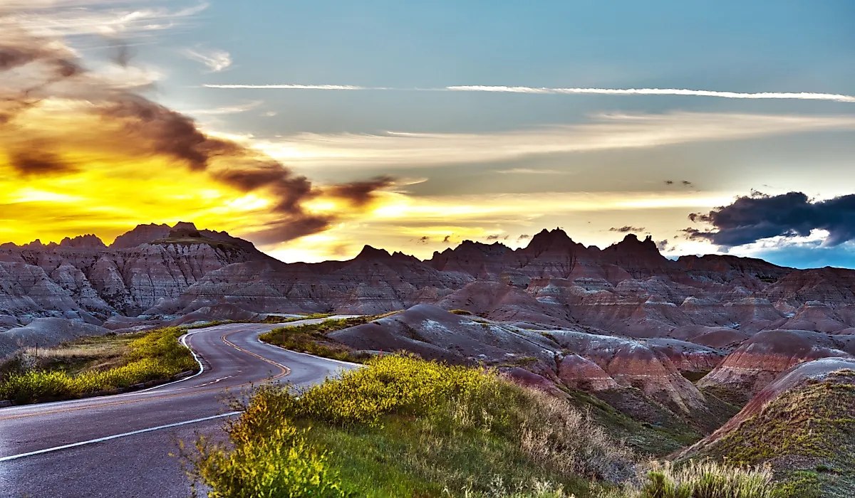
Badlands Loop State Scenic Byway: Wall To Wall

The small town of Wall serves as the gateway to Badlands National Park, a surreal landscape of eroded cliffs, colorful buttes, and sprawling prairie grasslands. From there, the 39‑mile Badlands Loop Scenic Byway winds through some of the park’s most dramatic scenery. The round trip to and from Wall takes about 1.5 to 2 hours, but it’s worth allowing extra time to stop and explore.
Stop at Big Badlands Overlook for a sweeping view of the striped rock formations, then stroll along the Window Trail, an easy boardwalk leading to a natural “window” framing the rugged landscape beyond. Keep an eye out for prairie dogs, and if luck is on your side, you might spot bighorn sheep scaling the cliffs. The park is also rich in fossils, preserving the remains of ancient mammals that once roamed the land.
After completing the loop, drive back to Wall and stop into Wall Drug, a famous roadside attraction offering 5-cent coffee, freshly-made donuts, and quirky photo ops to make your South Dakota road trip even more memorable.
Peter Norbeck Scenic Byway: Keystone To Mount Rushmore National Memorial

A memorable scenic option in the Black Hills is the drive from Keystone to Mount Rushmore National Memorial via Highway 16A (Iron Mountain Road), which forms part of the famed Peter Norbeck Scenic Byway. Beginning in Keystone, this beautifully engineered route covers about 17 miles one way, with a round trip of around 34 miles, typically taking 1 1/2 to 2 hours.
Along the winding road, you’ll cross pigtail bridges that loop back under themselves and pass through rock tunnels. Pause at Norbeck Overlook for a sweeping vantage point of the presidential faces against pine‑covered hills. The route ends at Mount Rushmore National Memorial, where you can extend your visit with a ranger talk, a trip to the Lincoln Borglum Visitor Center, or a walk along the Presidential Trail before looping back to Keystone.
Spearfish Canyon Scenic Byway: Spearfish To Cheyenne Crossing

Roughlock Falls in Spearfish Canyon, South Dakota, USA. via Wikicommons
Starting in the northern Black Hills town of Spearfish, the 19-mile drive along the Spearfish Canyon Scenic Byway winds along Highway 14A, through towering limestone cliffs and past rushing streams. It takes 30 to 40 minutes each way, making the round trip roughly 1 1/2 to 2 hours. Pull over at Bridal Veil Falls, one of the easiest waterfalls to reach in Spearfish Canyon.
A few miles farther, the short trail to Roughlock Falls leads to a multi‑tiered waterfall tucked among evergreens. Once you reach Cheyenne Crossing, a cozy outpost at the canyon's end, stop at Stage Stop Café, one of the best places to eat and shop, before looping back to Spearfish through the canyon.
Needles Highway: Custer To Hill City

Custer is a perfect jumping-off point for the Needles Highway, one of South Dakota’s most iconic drives. The 14-mile stretch through Custer State Park takes about 1 to 1 1/2 hours each way. The road winds past sharp granite spires and squeezes through narrow rock tunnels, including Needles Eye Tunnel, a one-car-wide passage next to a granite pillar shaped like the eye of a needle.
After threading through the tunnel, stop at Sylvan Lake, where you can walk the shoreline trail or spread out a picnic on the rocks. Wildlife is part of the adventure, so watch for mule deer in the trees, bison grazing in the meadows, and the occasional mountain goat perched high on the rocks. The drive ends in Hill City, a laid‑back town with art galleries, wineries, and a laid-back main street.
Mitchell To Chamberlain

The Corn Palace, partially decorated in July 2020, seen from North Main Street in Mitchell, South Dakota, United States via Wikicommons
For another scenic drive in South Dakota, start in Mitchell, home to the Corn Palace, where the corn‑husk murals are redesigned each year. Before leaving town, the Dakota Discovery Museum offers exhibits about the history and culture of the plains. From Mitchell, travel west on I‑90 for about 70 miles—around an hour each way and just over 2 hours round trip. The highway passes through open prairies and farmland, with small towns like Kimball, where Ditty’s is a common stop for travelers.
In Chamberlain, a bluff overlooking the Missouri River features the Dignity of Earth and Sky statue, a 50‑foot sculpture honoring Native American heritage. The town is also home to the Aktá Lakota Museum & Cultural Center, which shares the culture and history of the Lakota people. After visiting, return to Mitchell along the same route.
Belle Fourche To Belle Fourche Reservoir

On the northern edge of the Black Hills, Belle Fourche—the geographic center of the 50 states—serves as the starting point for a short, peaceful drive. Less than 10 miles east of town, about a 20‑minute drive each way, is Belle Fourche Reservoir, also known as Orman Dam. With time to explore, the outing takes about 2 hours or a bit longer.
While there, picnic by the water, try fishing, or take in the views from the historic earthen dam, once the largest in the world. Back in Belle Fourche, stop at the Geographic Center of the Nation Monument, then explore the Tri‑State Museum to learn about the area’s cattle‑ranching, railroad, and frontier history.
These scenic routes show different sides of South Dakota, from the granite spires along the Needles Highway to the quiet water of Belle Fourche Reservoir. Stops along the way might include the Dignity of Earth and Sky statue above the Missouri River or the Presidential Trail at Mount Rushmore National Memorial. Each drive is short enough for a day trip but gives time to see small towns, local history, and some of the state’s most memorable scenery.