10 Most Scenic Road Trips To Take In Utah
The state of Utah presents a smorgasbord of scenic drives that will leave motorists perpetually salivating for more. The terrain is vast and scarred with stunning canyons, defiant mountains, random but complex rock formations, fossil and archeological remnants from distant eras, and plenty of cool pit-stop or side-trip lookouts, interpretive sites, hikes, towns, parks, and even additional branching roadways. Utah is a valued chunk of many inspiring National Scenic Byways and All-American Roadways. Also, it contributes its own slew of state-sponsored drives across a wide spectrum of lengths and intensities. Depending on your odometer goals and gas fund, these are best, most scenic road trips to undertake in the Beehive State.
Nine Mile Canyon

Cutting through the Book Cliffs of Eastern Utah is the must-see Nine Mile Canyon, dubbed "the longest art gallery in the world." In this already seemingly sculpted place, the prehistoric Fremont Culture, Ute people, and other indigenous groups inscribed over 10,000 petroglyphs onto the canyon walls. The 46-mile-long (one-way), winding Nine Mile Canyon Road brings these ancient and captivating works of art into view. Yes, despite the name, this road trip will chew up some solid miles. Thankfully, the road has been recently paved, which makes the going a little easier for casual motorists but also spares the petroglyphs from harm that the kicked-up dust was causing over the years. Nine Mile Canyon Road can be accessed off Highway 191, near the Utah/Colorado border towns of Helper and Price.
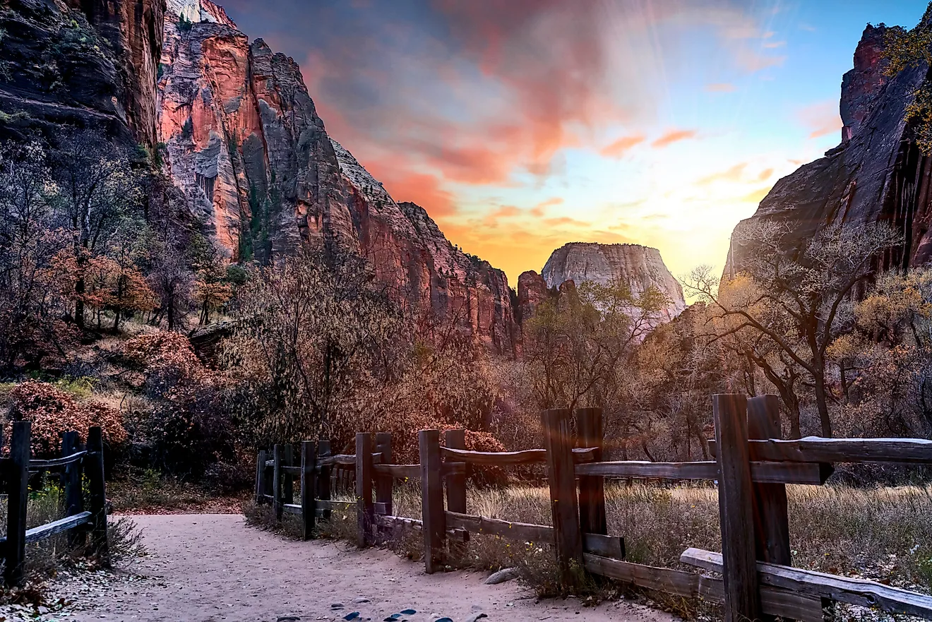
Zion National Park Roadways

Picturesque and world-famous Zion National Park has a few great options for exploring with wheels. A lovely lead-up to the East entrance is the Zion National Scenic Byway (i.e., State Route 9), which begins at the intersection with State Route 17 in the city of La Verkin and cruises for 54 miles to the park entrance and then onwards to Mount Carmel Junction. Along the way, the byway passes through the towns of Rockville and Springdale and the mile-long Zion-Mount Carmel Tunnel. Also en route is the turnoff for Zion Canyon Scenic Drive. If adventuring after the American Thanksgiving long weekend, motorists can continue in their own car along this cherished drag. However, during peak season (i.e., late spring to early fall), visitors must transfer to the official shuttles to ease the congestion in the heart of the park.
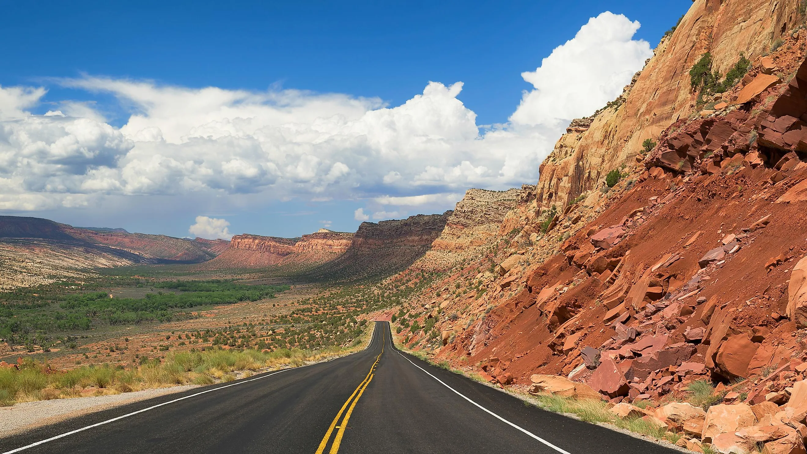
Trail Of The Ancients National Scenic Byway

The Utah segment of the Trail of the Ancients National Scenic Byway provides an extensive tour through the past and present stomping grounds of the Ancestral Puebloan and other Indigenous peoples of the Four Corners region (i.e., the modern-day meeting point of Utah, Colorado, Arizona, and New Mexico). It is recommended to break this over 400-mile drive up into two or three-day chunks in order to hit all of the amazing stops spread across sections of U.S. 191 and 163 and State Route 261 and 262. Such highlights include the cliff dwellings of the Canyonlands region, Edge of the Cedars State Park Museum, Hovenweep National Monument, Monument Valley Navajo Tribal Park, Valley of the Gods, and Natural Bridges National Monument, to name a few. Round trippers can return the way they came, perhaps saving certain stops for the return journey, or jump on this next entry to switch up the scenery.
Bicentennial Highway

Southeastern Utah's Bicentennial Highway (U.S. 95) is a perfect complement to the culturally-focused Trail of the Ancients National Scenic Byway. This highway goes for 133 miles from the small town of Hanksville back to the San Juan city of Blanding (where the Edge of the Cedars State Park Museum, a highlight shared with the Trail of the Ancients, can be found). To the West, views of the Henry Mountains can be enjoyed. The road then dives into classic canyon country before booting across the long and lean Lake Powell/Colorado River at the Hite Crossing Bridge (near the arresting Hite Overlook). And as with the Trail of the Ancients, a side-trip loop around Bridge View Drive in Natural Bridges National Monument is a must.
Connecting Arches, Dead Horse, And Canyonlands

This one is more of a makeshift road trip, based out of Moab, with a bunch of cool stops that can be made at your leisure. For starters, head North into Arches National Park and make the out-and-back journey on Arches Scenic Drive. Depending on how much time you invest in the various viewpoints and hikes, either return to Moab to enjoy the offerings of this pretty desert town or head up to the turn-off for UT-313, marked by the Moab Giants Dinosaur Park. Shoot all the way down to Dead Horse State Park, and then backtrack to Grand View Point Road and descend into Canyonlands National Park/the Island in the Sky mesa.
Dinosaur Diamond Prehistoric Highway National Scenic Byway

After returning from Canyonlands, why not spend one more night in Moab, fill up that gas tank, and then embark on the epic 512-mile Dinosaur Diamond Prehistoric Highway National Scenic Byway? This roughly diamond-shaped road trip travels across parts of both Utah and Colorado, focusing on the prehistoric giants that once dominated the Four Corners region of the United States. Fossils are still being uncovered at active archeological dig sites along the way. The ones that have already been cleaned and cataloged can then be viewed at the nearby museums, including the Prehistoric Museum at Price's Utah State University Eastern and the open-air Dinosaur National Monument fossil bone quarry!
Potash Scenic Byway

On the other hand, if a shorter, Moab-based, add-on road trip is all that is desired, scoot off on the Potash-Lower Colorado River Scenic Byway for 17 miles of bliss. State Route 279, or simply Potash Road, is a hidden gem drive and, given the low density of traffic, is also a favorite among cyclists. This route follows the curves of the Colorado River all the way to the border of Canyonlands National Park. The river is contrasted by prominent sandstone cliffs and a popular climbing spot known as Wall Street. Right out of the gates, this drive offers terrific views of Moab Valley. Next, jump out at Potash Road Dinosaur Tracks and Petroglyphs to appreciate the accidental imprints left behind by the extinct giants and the intentional markings left behind by some of the area's first human inhabitants. And all the while, keep a keen eye for those amazing arches and creative rock formations that Utah is famous for.
Scenic Byway 12

Utah's State Route/Scenic Byway 12 is designated as an "All-American Road," meaning it exemplifies particularly unique features of the country's landscape. This 123-mile stretch links U.S. 89, just South of the city of Panguitch (the Western terminus), with State Route 24, just East of the town of Torrey (the Northeastern terminus). Travelers will get a taste of the Dixie National Forest, the army of hoodoos at Bryce Canyon National Park, a view of the Henry Mountains, the sandstone cliffs of Grand Staircase-Escalante National Monument, the pastel hues of Capitol Reef National Park, plus the state parks of Kodachrome Basin, Escalante Petrified Forest, and Anasazi Museum), with random tunnels and eye-catching rock formations randomly punctuating the drive.
Flaming Gorge-Uintas Scenic Byway

Over in the state's Northeast corner, hugging the Southwestern Wyoming border, Flaming Gorge-Uintas National Scenic Byway offers a tour rich in scenery, wildlife, and education. This section of U.S. 191 and UT-44 runs from Vernal to Manila, with 15 "Wildlife Through the Ages" interpretive sites/trails that expound on the diverse lifeforms and environments that have had their reign over the years. The Flaming Gorge National Recreation Area brings this trip to a close on a particularly high note. Here, drivers can transition into boaters and zip around the large artificial reservoir formed by the Green River and Flaming Gorge Dam and enveloped by the steep, tree-splattered hills.
Mirror Lake Scenic Byway

While burning rubber in the Northeast, consider tacking on the 56-mile Mirror Lake Scenic Byway. Though modest in terms of length, this route gains some serious and seriously-scenic elevation. This section of State Route 150 begins in the quaint settlement of Kamas, just 43 miles East of that state capital, Salt Lake City. From there, the byway chugs upwards into the High Uintas Mountains, topping out at 10,715 feet through Bald Mountain Pass and claiming the crown of Utah's highest paved road in the process. Consider pulling over and taking the 2.5-mile (one-way) steep hike to the summit of Bald Mountain for truly sensational views. Other peaks in this East-West mountain range (one of the few in the country) and the highly-reflective Mirror Lake come out to play on the descent before reaching the border with Southwestern Wyoming.
With so many chart-topping national, state, and native parks/monuments, having a car is essential for taking in all Utah offers. Sometimes the trick is to drive just a little bit at a time, taking many breaks along the way or transitioning to an adventure on foot (rope, boat, or bicycle). But on other occasions, it can be rewarding to bank a ton of miles and appreciate how much the landscape can change with the climbing odometer. The best road trip is the one that calls to you, but these ten entries are a great place to start.