Gulf of Tonkin
Referred to as “Beibu Gulf” in Chinese and “Bac Bo Gulf” in Vietnamese, the Gulf of Tonkin is a crescent-shaped, shallow, semi-enclosed water body situated off South China and Northern Vietnam coasts in the South China Sea’s northwestern portion. The 300 miles-long and 150-mile-wide gulf receives significant inflows from the Red River. In Northern Vietnam, the gulf’s main ports include Haiphong and Ben Thuy, whereas, in China, its major port is Beihai (Pakhoi). The Gulf of Tonkin is best known for the infamous “Gulf Of Tonkin Incident,” which led the US Congress to pass the “Gulf of Tonkin Resolution,” eventually leading to a direct engagement of the United States in the Vietnam War.
Geography Of The Gulf Of Tonkin

Covering a total surface area of 48,750 sq. mi, the relatively shallow Gulf of Tonkin reaches a maximum depth of 230 ft. The gulf is bordered by the northern coastline of Vietnam in the west and northwest; by China’s Guangxi Zhuang Autonomous Region in the north; and by the Leizhou Peninsula and Hainan Island in the east. The Gulf of Tonkin is connected with the South China Sea via the gulf’s mouth in the south and the Hainan Strait (Qiongzhou Strait) in the northeast. The 12.43-mile-wide and 328 ft deep Hainan Strait is the principal shipping route between Hainan Island and China’s Leizhou Peninsula.

The Gulf of Tonkin is the northwestern arm of the South China Sea, which is the most extensive marginal sea in the Northwest Pacific Ocean. Many rivers empty into the Gulf of Tonkin, with the Red River supplying the major riverine discharge along with some smaller rivers along the northern and western coastal areas. Also known as the Yuan River in Chinese, the 714-mile-long Red River begins its journey from the mountainous regions of the landlocked Yunnan province in Southwest China and flows southeastwards through the Honghe Autonomous Prefecture and into the northern part of Vietnam, where it receives waters from the Black (Da) and Lo rivers before draining into the Gulf of Tonkin through 9 distributaries in its delta. Annually the Red River carries about 82 x 106 cubic meters of sediment and eventually empties into a shallow shelf sea, forming a river plume deflected in the southward direction by coastal currents.
Etymology Of The Gulf Of Tonkin
The name ‘Tonkin,’ written in Hán-Nôm characters and the Vietnamese alphabet, means ‘Eastern Capital’ and refers to the previous toponym for Hanoi, Vietnam’s present capital city. During the 17th and 18th centuries, the term referred to the Dang Ngoai domain, which included both the Northern and Thanh-Nghe regions of Vietnam, located north of the Gianh River under the control of the Trinh lords. From 1883 to the beginning of 1945, the name Tonkin was used to refer to the French protectorate of Tonkin that encompassed present-day Northern Vietnam.
History Of The Gulf Of Tonkin

After the end of the First Indochina War and the Viet Minh defeat of the French colonialists in July 1954, a meeting of the nations at the Geneva Conference decided to divide Vietnam into southern and northern portions, which were to be administered by the State of Vietnam and Viet Minh, respectively. The Geneva Accords also scheduled a general election to establish a unified Vietnamese State by July 1956. Due to their superior organization and greater appeal, it seemed that the communists were most likely to win the elections. To contain the spread of communism in Southeast Asia, the United States invoked a charter of the Southeast Asia Treaty Organization and supported Ngo Dinh Diem, the South Vietnamese leader, when he refused to hold the elections. However, Ngo Dinh Diem failed to prevent communist infiltration, and by 1959, a large-scale insurgency began, which marked the beginning of an open war between North and South Vietnam.
By 1963, the reign of Ngo Dinh Diem had deteriorated so much that he was eventually overthrown and assassinated by several of his generals. US President John F. Kennedy was assassinated within three weeks of this incident, and the Second Indochina War began continuing under the new leadership of both nations.

President Lyndon B. Johnson, who succeeded Kennedy, believed that the only solution to this problem was the escalation of the US presence in Vietnam. Besides supporting the ongoing South Vietnamese raids in the countryside, the US military also helped back such attacks on the North Vietnamese coast. To support the military actions, two destroyers, namely the USS Maddox and the USS Turner Joy, were stationed by the US Navy in the Gulf of Tonkin. On August 2, 1964, USS Maddox was attacked by three North Vietnamese motor torpedo boats. USS Turner Joy joined USS Maddox on August 3, 1964, and the two destroyers continued their patrols. On the evening of August 4, the two ships opened fire on radar returns. Captain John Jerome Herrick, who served as the commander of the Maddox task force, thought that the ships were being attacked by North Vietnamese boats.
In response to these reported incidents, President Lyndon B. Johnson sought the US Congress’s permission to increase military presence in Indochina. A joint session of the US Congress passed the “Gulf of Tonkin Resolution,” authorizing President Johnson to take all necessary measures to repel any armed attack against the US armed forces and prevent further aggressions. The resolution also allowed the US President to assist any Southeast Asian country whose government was considered to be threatened by “communist aggression.” The Gulf of Tonkin Incident thus kickstarted the Vietnam War that claimed 58,200 American lives along with 250,000 South Vietnamese troops, 1.1 million Viet Cong and North Vietnamese fighters, and over 2 million civilians across the country.

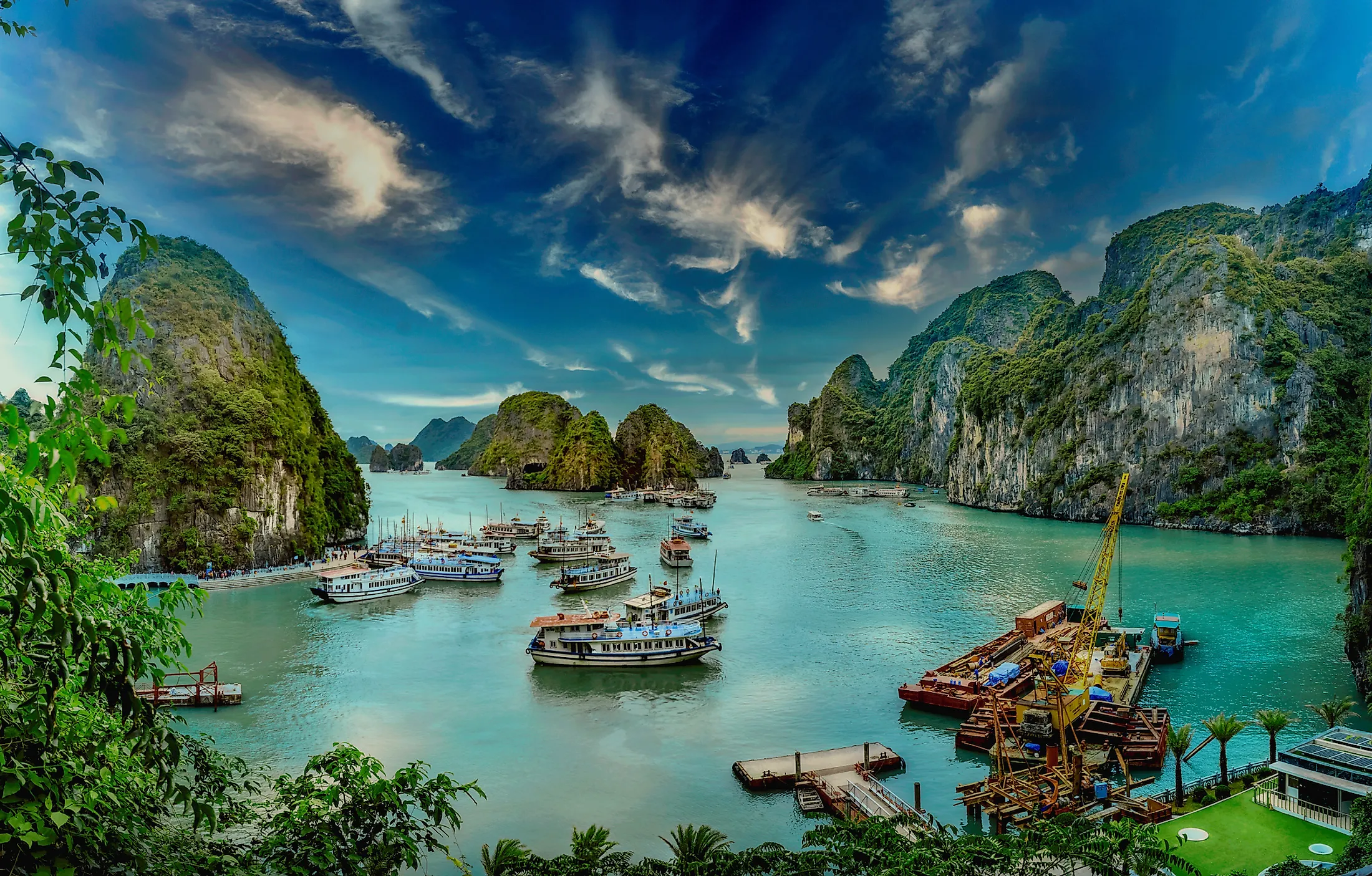
The Gulf of Tonkin is of utmost importance for both the bordering nations of China and Vietnam. The Gulf supports several marine species that are of economic significance to the inhabitants of both nations. Moreover, as per estimations by the China National Offshore Petroleum Company, the Gulf area has one of the world’s most extensive oil and gas concentrations, with an oil deposit of about 2.29 billion tons and 1,444 billion cubic meters of natural gas deposits. In addition, Vietnam’s Ben Thuy and Haiphong ports and China’s Beihai Port enable the two nations to carry out trading activities via the Gulf of Tonkin. To perfectly protect the gulf’s fragile ecologically sensitive areas, such as the Cat Ba Island National Park and Ha Long Bay, in combination with sustainable economic growth, it is essential to have a proper knowledge of the entire Gulf of Tonkin region.