Maps of Latvia

Latvia, a Baltic state in Europe lies along the eastern shores of the Baltic Sea and covers an area of 4,589 sq. km (24,938 sq mi).
As observed on the physical map of the country above, Latvia is a very flat country of low-lying plains, largely covered by forest. There are some low hils in the west and far southeast. About 98% of Latvia has an elevation of less than 200 m (656 ft).
A few high hills are found to the east of Riga, with the highest point being the Gaizinkalns at 311.6 m (1,022 ft). It has been marked on the map by a yellow triangle.
There are over 3,000 small lakes in the country. Latvia also has numerous rivers, earnly 12,000. However, most rivers are extremely short. Only 17 rivers flow for more than 100 km (60 mi). As observed on the map above, important rivers include the Daugava, Gauja, Lielupe, Venta and Salaca.
The lowest point of Latvia is the Baltic Sea at 0 m.
Municipalities of Latvia Map

Latvia (officially, Republic of Latvia) is divided into 110 municipalities (novadi, sing. novads) and 9 cities (republikas pil setas). In alphabetical order, the municipalities are: Adazu Novads, Aglonas Novads, Aizkraukles Novads, Aizputes Novads, Aknistes Novads, Alojas Novads, Alsungas Novads, Aluksnes Novads, Amatas Novads, Apes Novads, Auces Novads, Babites Novads, Baldones Novads, Baltinavas Novads, Balvu Novads, Bauskas Novads, Beverinas Novads, Brocenu Novads, Burtnieku Novads, Carnikavas Novads, Cesu Novads, Cesvaines Novads, Ciblas Novads, Dagdas Novads, Daugavpils Novads, Dobeles Novads, Dundagas Novads, Durbes Novads, Engures Novads, Erglu Novads, Garkalnes Novads, Grobinas Novads, Gulbenes Novads, Iecavas Novads, Ikskiles Novads, Ilukstes Novads, Incukalna Novads, Jaunjelgavas Novads, Jaunpiebalgas Novads, Jaunpils Novads, Jekabpils Novads, Jelgavas Novads, Kandavas Novads, Karsavas Novads, Keguma Novads, Kekavas Novads, Kocenu Novads, Kokneses Novads, Kraslavas Novads, Krimuldas Novads, Krustpils Novads, Kuldigas Novads, Lielvardes Novads, Ligatnes Novads, Limbazu Novads, Livanu Novads, Lubanas Novads, Ludzas Novads, Madonas Novads, Malpils Novads, Marupes Novads, Mazsalacas Novads, Mersraga Novads, Nauksenu Novads, Neretas Novads, Nicas Novads, Ogres Novads, Olaines Novads, Ozolnieku Novads, Pargaujas Novads, Pavilostas Novads, Plavinu Novads, Preilu Novads, Priekules Novads, Priekulu Novads, Raunas Novads, Rezeknes Novads, Riebinu Novads, Rojas Novads, Ropazu Novads, Rucavas Novads, Rugaju Novads, Rujienas Novads, Rundales Novads, Salacgrivas Novads, Salas Novads, Salaspils Novads, Saldus Novads, Saulkrastu Novads, Sejas Novads, Siguldas Novads, Skriveru Novads, Skrundas Novads, Smiltenes Novads, Stopinu Novads, Strencu Novads, Talsu Novads, Tervetes Novads, Tukuma Novads, Vainodes Novads, Valkas Novads, Varaklanu Novads, Varkavas Novads, Vecpiebalgas Novads, Vecumnieku Novads, Ventspils Novads, Viesites Novads, Vilakas Novads, Vilanu Novads and Zilupes Novads. The cities of Latvia are: Daugavpils, Jekabpils, Jelgava, Jurmala, Liepaja, Rezekne, Riga, Valmiera and Ventspils.
The municipalities are further subdivided into a number of smaller subdivisions.
Strategically located between Eastern and Western Europe, at the mouth of the Daugava River on the Baltic Sea’s southern shores is, Riga – the capital, the largest and the most populous city of Latvia. Riga is the biggest city in the Baltic States.
Where is Latvia?

Latvia is a Baltic country situated in North Eastern Europe. Latvia is positioned both in the Northern and Eastern hemispheres of the Earth. Latvia is bordered by 4 Nations: by Estonia in the north; Lithuania in the south; Belarus in the southeast and Russia in the east. Latvia lies along the eastern shores of the Baltic Sea and the Gulf of Riga. Latvia shares its maritime borders with Sweden.
Latvia Bordering Countries: Russia, Estonia, Belarus, Lithuania.
Regional Maps: Map of Europe
Outline Map of Latvia

The blank outline map is of Latvia, a country located in Europe along the easter shores of the Baltic Sea. The map can be downlodaded and printed. It can be used for geography education or for coloring.

The outline map above represents Latvia, a country located in northeastern Europe with a coastline on the Baltic Sea to the west.
Key Facts
| Legal Name | Republic of Latvia |
|---|---|
| Flag |
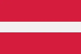
|
| Capital City | Riga |
| 56 57 N, 24 06 E | |
| Total Area | 64,589.00 km2 |
| Land Area | 62,249.00 km2 |
| Water Area | 2,340.00 km2 |
| Population | 1,912,789 |
| Largest City |
Riga (621,369) |
| Currency | Euros (EUR) |
| GDP | $34.12 Billion |
| GDP Per Capita | $17,836.36 |
This page was last updated on February 24, 2021