8 Most Relaxing Utah Towns
Utah's quieter towns share a few traits that make them genuinely restful rather than scenic in the postcard sense. Most sit a long enough drive from the major national parks that the visitor traffic falls away. Most retain working agricultural land, which keeps the pace tied to irrigation cycles and ranch schedules rather than tourist seasons. Many sit at high enough elevation, far enough from urban light, to deliver the kind of night sky that has gone missing from most of the country, and a few have written that protection into their lighting ordinances. The eight towns below cover preserved 19th-century Mormon settlement architecture, working ranching country, dark-sky communities, and red-rock canyon settings without the pressure of a national-park gateway.
Spring City

Spring City is one of only a handful of communities in the country where the entire town limits are listed on the National Register of Historic Places as a single historic district. Designated in 1980 (and updated in 2022), the district recognizes Spring City as the most intact surviving example of a Latter-day Saint Mormon Village settlement, with its original Plat of Zion grid still legible on the landscape and more than 200 residences in Scandinavian and American architectural styles still standing.
James Allred, directed by Brigham Young, led the original settlers here in 1852. The town was burned in the Walker War of 1854 and reestablished in 1859, this time with a wave of newly arrived Danish stonemasons whose work in the locally quarried Sanpete oolite limestone defines the town's most recognizable buildings. The LDS meetinghouse, designed by Provo architect Richard C. Watkins and built in oolite limestone between 1902 and 1911, is the dominant structure in the district.
Population peaked at about 1,230 in 1890 and declined for decades after, which is part of why so much survived intact. Artists began moving to Spring City in the 1970s, drawn by the architecture and the surrounding landscape. The local nonprofit Spring City Arts now runs a gallery in a restored early-20th-century automobile showroom on Main Street. Palisade State Park, about 15 miles south, surrounds a 70-acre reservoir for fishing, boating, and paddling.
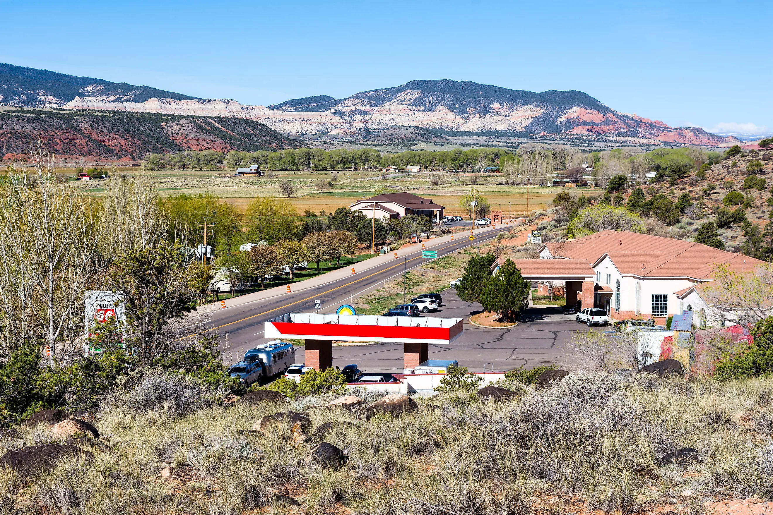
Huntsville

Huntsville sits in Ogden Valley beneath the Wasatch Mountains, surrounded by farmland, alpine terrain, and reservoir shorelines. The town offers proximity to hiking trails, ski terrain, and reservoir access without the resort density of the developments elsewhere in northern Utah.
Jefferson Hunt and several families established the first farms here in 1860 along mountain streams. Scandinavian immigrants followed in 1864 and expanded the irrigation systems that supported crops and livestock. The population grew past 800 by 1880.
Causey Reservoir, 11 miles east of town, was completed in 1966. It fills a narrow canyon used by kayakers and paddleboarders with anglers along the shoreline.
Randolph

Ranching drives much of Randolph's economy. Cattle and sheep operations occupy land throughout the Bear River Valley beneath the Crawford Mountains. The town has served the surrounding ranches since Mormon settlers established it in 1870.
Within a year of its founding, Randolph had a post office, general store, blacksmith shop, and sawmill. Two historic buildings now anchor Main Street: the Wilford Woodruff Home, a two-room log cabin from 1871, and the Randolph Tabernacle, a Victorian Eclectic brick meetinghouse completed in 1914 and dedicated on July 26 of that year. Local craftsmen built it over several years using red brick manufactured in the valley. Little Creek Reservoir near town is used for fishing, and Little Creek Campground overlooks the valley.
New Harmony

Mountain runoff from the Pine Valley Mountains supported farming when settlers established New Harmony in 1852, and agriculture and small-scale ranching continue in the town today.
The Comanche Trail, a demanding hike, starts in New Harmony and climbs through Comanche Canyon. It gains roughly 2,657 feet over 12 miles before connecting with the Summit Trail along the northern slopes of the Pine Valley Mountains. The lower sections sit outside the Pine Valley Mountain Wilderness boundary, so mountain bikes are permitted there.
Annabella

Annabella remains a small agricultural town in Utah's Sevier Valley, surrounded by irrigated farmland. Settlers founded the community in 1871 along two creeks flowing through the valley and named it after Anna Roberts and Isabella Dalton, two women from the original pioneer group.
Farming operations expanded along the creeks and still occupy much of the surrounding valley. Bull Claim Hill rises 1,300 feet east of town and offers views across the farmland. Fishlake National Forest is about 25 minutes away by car and opens access to forest roads and trails. Red Hill Hot Springs, 14 minutes from town, flows over red-rock terraces into a series of soaking pools, each cooler than the last.
Hyrum

Hyrum developed as a farming town in southern Cache Valley and agriculture still shapes much of the landscape around it. In 1860, 23 families established farms here, and the town was named for Hyrum Smith, the brother of LDS founder Joseph Smith. Irrigation networks supported grain farms, orchards, and dairy operations as the community grew.
Hyrum Reservoir, completed by the Civilian Conservation Corps in 1935, covers roughly 450 acres just outside town. Hyrum State Park surrounds the lake and provides boating, fishing, swimming, and camping access. Elite Hall, a two-story brick building from 1917, is one of the town's most recognizable historic structures and is listed on the National Register of Historic Places.
Torrey

Torrey was certified as Utah's first International Dark Sky Community in 2018. Only 18 communities worldwide held the designation at that time. The town's lighting ordinance requires outdoor lights to be shielded and directed downward, and a community fundraising campaign retrofitted the town's high-pressure sodium streetlights with fully-shielded LEDs ahead of the certification.
Torrey stands at 6,837 feet in Wayne County between Boulder Mountain and the red-rock cliffs of Capitol Reef National Park, which itself was certified as an International Dark Sky Park in 2015. The combined dark-sky protection over the park and gateway town allows reliable visibility of the Milky Way core and on clear nights the Andromeda Galaxy with the naked eye.
Mormon settlers built irrigation ditches along the Fremont River starting in the 1880s, establishing farms and ranches that still operate around the town. Capitol Gorge in the park preserves the Pioneer Register, where travelers carved their names into the sandstone wall between 1871 and the early 1900s. The town's roughly 240 to 300 residents host the annual Heritage Starfest each fall.
Rockville

Rockville sits in the canyon of the Virgin River with red-rock cliffs and open fields on all sides. Mormon pioneers settled it in 1862, and the town's grid has held its shape since. The Rockville Bridge, built in 1924, is the only surviving Parker through-truss bridge still used for vehicular travel in Utah.
The single-lane bridge spans the Virgin River and leads to Grafton, a ghost town 3.5 miles away. Grafton's last residents left in 1944, and the partially restored townsite has been used as a film location for several Westerns. Rockville sits about five miles west of the Zion Visitor Center but with much lower population and development density.
A Quieter Side of Utah
Utah is best known for its national parks and major recreation areas. The eight communities above offer something different in scale and pace: preserved historic districts, working farmland, reservoir afternoons, dark-sky nights, and local trail access without the gateway-town crowds.