11 Of The Most Adorable Small Towns In The Great Lakes
The Great Lakes region is one of the most fascinating regions in North America. Exquisitely diverse, it is a melting pot of American and Canadian traditions while simultaneously being home to some of the most stunning natural scenery in the world. What more can one ask for?
If you want to experience all that the region has to offer, come along on our exploration of its 11 most adorable towns. Brace yourself for ridge-top views on Brockway Mountain Drive, cliff country at Pictured Rocks National Lakeshore, and dockside pauses timed to the opening of Little Current Swing Bridge. Below are the creme-de-la-creme of the Great Lakes.
Killarney, Ontario

White quartzite ridges rise abruptly behind a single road and working marina, placing Killarney between exposed stone and the North Channel of Lake Huron. The settlement occupies a narrow coastal opening where commercial fishing, park access, and boat traffic converge. Its physical scale remains fixed by surrounding protected land, with most development confined to the harbor edge. The contrast between pale rock formations and dark water has drawn painters since the early twentieth century, shaping the town’s long association with landscape art and wilderness travel.
Killarney Provincial Park begins immediately outside town, with access to George Lake beaches and the La Cloche Silhouette Trail. Herbert Fisheries operates directly on the dock, selling whitefish and pickerel from a counter facing the channel. Killarney Mountain Lodge anchors the harbor with a wooden boardwalk and mooring slips. George Lake provides clear water access framed by exposed rock and pine, linking the town directly to the park’s interior routes.
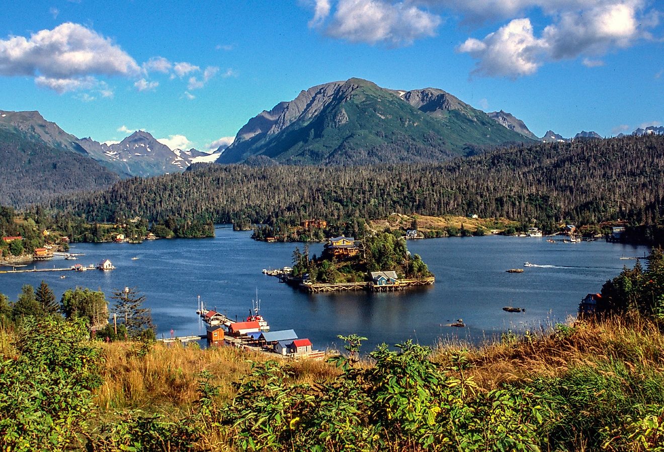
Copper Harbor, Michigan

At the northern end of the Keweenaw Peninsula, Copper Harbor occupies a narrow pocket of land where forest, basalt, and open water converge. The town developed as a copper shipping point in the nineteenth century, and its street plan still reflects that origin: one main road, a compact harbor, and long sightlines toward Lake Superior. The surrounding terrain rises quickly, shaped by ancient lava flows rather than sand or sediment, giving the village a physical isolation reinforced by distance from larger settlements. Weather systems arrive unobstructed from the lake, and the harbor remains the town’s organizing feature, used by charter boats, research vessels, and seasonal ferry traffic.
Brockway Mountain Drive climbs above town, providing elevated views across forest canopy and water from roadside pullouts. Fort Wilkins Historic State Park preserves officers’ quarters, barracks, and parade grounds from the copper boom era. The Copper Harbor Lighthouse marks the entrance to the bay and connects the village to regional maritime routes. Hunter’s Point Park extends into the lake on a narrow spit, offering shoreline access among exposed rock shelves and spruce.
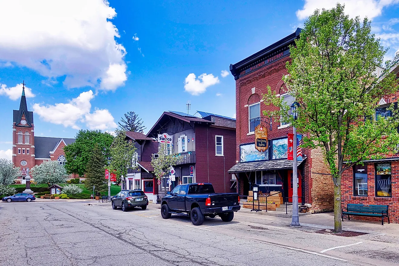
Bayfield, Wisconsin

Bayfield rises gently from a protected harbor on Lake Superior, its grid of narrow streets ending abruptly at water and forest. Bayfield functions as both a working port and a logistical hinge for the lake’s northern archipelago. Commercial fishing docks, sailing charters, and ferry slips share the same compact shoreline, creating a town shaped by departures and returns. The presence of freshwater orchards surrounding the city adds an agricultural layer unusual for a Lake Superior harbor, tying seasonal rhythms to both water and land.
Apostle Islands National Lakeshore defines the town’s role on the lake, accessed by boat tours and kayak launches from the municipal marina. The Madeline Island Ferry Line departs directly from town, maintaining a constant flow between Bayfield and La Pointe. The Manypenny Bistro occupies a former general store, serving regional dishes in a brick-lined dining room near the harbor. Bayfield Maritime Museum documents shipbuilding, ore transport, and fishing history through tools, models, and photographs drawn from local families.
Munising, Michigan

Sheer sandstone faces rise directly from deep water just east of town, giving Munising a relationship with Lake Superior defined by cliffs rather than beaches. The town developed as a rail and shipping point for timber and limestone, and its harbor still aligns with industrial logic rather than ornament. Streets run inland from the bay into dense forest, while the shoreline remains a working edge of docks, tour vessels, and cargo infrastructure. The proximity of exposed rock formations to the town center places large-scale geology within walking distance of daily life.
Pictured Rocks National Lakeshore begins at the city limits, accessed by boat cruises departing from the municipal dock and by trailheads along Sand Point Road. Miners Falls sits inland off H-58, where a 0.6-mile walk reaches a 50-foot drop over a sandstone outcrop. The Falling Rock Café & Bookstore operates near the waterfront, pairing regional food with shelves of Great Lakes history. Sand Point Beach lies about four miles northeast of town at the end of Sand Point Road, sheltered along Munising Bay.
Little Current, Ontario

Steel and water intersect at a single choke point where the North Channel narrows, giving Little Current its purpose and identity. The community formed around this crossing, where vessels pause and schedules bend to the movement of a swing bridge connecting Manitoulin Island to the mainland. Marina slips, chandlery storefronts, and dockside paths line the channel, and much of the town’s daily rhythm follows marine traffic rather than clocks. Sailboats, trawlers, and kayaks funnel through the same passage, turning the shoreline into a continuous working edge shaped by navigation and tide-like currents.
Little Current Swing Bridge dominates the waterfront, drawing onlookers whenever it opens to release queued boats into the channel. The Little Current Waterfront Walkway traces the shoreline past docks, parks, and mooring posts used by transient cruisers. Anchor Inn Hotel anchors the harbor stretch, pairing guest rooms and dining with direct views of passing vessels. The Little Current Yacht Club runs races and youth sailing programs and anchors the town’s sailing scene on the channel.
Gore Bay, Ontario

A curved harbor carved deep into Manitoulin Island gives Gore Bay its defining shape and purpose. The town occupies a natural bowl of water along the North Channel, where the shoreline rises in a clean arc from docks to hillside streets. Gore Bay developed as a port for timber and limestone, and the harbor still dictates its scale, with marina slips, breakwalls, and wharf buildings forming a tight waterfront core. The channel’s sheltered water attracts long-distance cruisers, placing transient boat life at the center of the town’s daily movement and economy.
Gore Bay Boardwalk follows the harbor edge, linking the marina to Fish Point Park through a continuous shoreline path. Noble Nature Trail climbs directly from town into forest and exposed rock, offering elevated views back toward the bay. Buoy’s Eatery sits near the docks, serving fish-focused meals tied to local waters. The Gore Bay Marina anchors the harbor, functioning as fuel stop, gathering point, and visual centerpiece for the town’s waterfront.
Tobermory, Ontario

Clear freshwater exposes shipwreck outlines beneath the harbor surface, setting Tobermory apart from other Great Lakes towns before a single building comes into view. The village sits at the northern tip of the Bruce Peninsula, where Georgian Bay meets the open waters of Lake Huron and limestone cliffs rise directly behind the docks. Tobermory developed as a fishing and shipping outpost, and its harbor remains the organizing feature, lined with charter boats, ferries, and low-rise storefronts pressed close to the water. The surrounding landscape belongs to the Niagara Escarpment, placing exposed rock, forest, and deep water in immediate proximity.
Bruce Peninsula National Park begins minutes from the harbor, with trails leading to the Grotto and cliff-edge viewpoints above turquoise water. Fathom Five National Marine Park supports glass-bottom boat tours and dive access to historic wrecks scattered around Flowerpot Island. The Shipwreck Lee’s operates along the main harbor stretch, serving fish and chips within view of departing boats. Little Tub Harbour anchors the village, functioning as marina, promenade, and focal point for daily activity.
Leland, Michigan

At the mouth of the Leland River, where it slips between Lake Leelanau and Lake Michigan, Leland announces itself through weathered fishing shanties balanced on pilings above cold, moving water. This working waterfront, known as Fishtown, remains an intact remnant of a commercial fishing economy that once defined the Leelanau Peninsula. Smokehouses, net sheds, and fish tugs still operate within inches of gift shops and docks, creating a compressed landscape where industry, history, and daily life share the same narrow strip of shoreline. The town’s scale sharpens every detail: gulls circling the river channel, whitefish packed on ice, and the steady current cutting through cedar-lined banks.
Carlson’s Fishery sells smoked chubs and fresh whitefish from counters facing the river. The Leelanau Historical Society & Museum preserves artifacts tied to shipping, fishing, and early settlement. The Fishtown Preservation Society maintains the shanties and docks of Historic Fishtown, keeping the working waterfront open along the river channel. Van’s Beach, tucked just west of the river mouth, delivers uninterrupted Lake Michigan horizon lines framed by rolling stones and evening light.
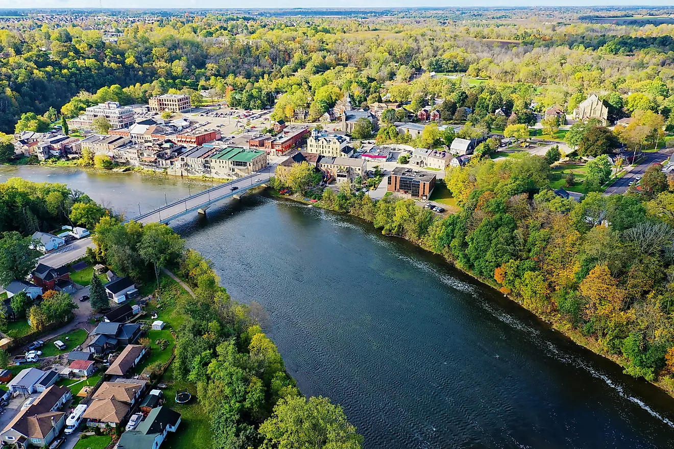
Picton, Ontario

Limestone storefronts and a compact harbor define Picton, a settlement shaped by Loyalist planning and inland navigation rather than open-lake exposure. The town sits at the head of Picton Bay, where ships once unloaded grain, timber, and stone bound for Lake Ontario routes. Its street grid reflects early nineteenth-century surveying, with Main Street rising directly from the water and civic buildings clustered within a few blocks. Picton’s role as the administrative center of Prince Edward County left it with courthouses, armories, and warehouses that remain in daily use, anchoring the town in function rather than spectacle.
Picton Harbour supports a municipal marina and walking paths tracing the bay’s edge. Regent Theatre operates from a restored opera house, hosting film screenings and live performances year-round. The Vic Social occupies a former general store dining room, serving seasonal menus tied to county farms. Sandbanks Provincial Park lies a short drive from town, where dune-backed beaches and shallow water extend Picton’s connection to Lake Ontario beyond the harbor.
Kelleys Island, Ohio

Shallow limestone shelves and quiet inland ponds give Kelleys Island a physical character unlike anywhere else on Lake Erie. The island sits low in the water, built almost entirely from ancient limestone shaped by continental ice. Its most defining feature lies inland rather than on the shore: vast stone corridors carved directly into bedrock by retreating glaciers more than 12,000 years ago. Streets thread through oak stands and quarry remnants, and the village core clusters near the ferry dock, where golf carts and bicycles replace traffic and the land’s geological history dictates the town’s pace and layout.
Glacial Grooves State Memorial preserves parallel channels worn deep into limestone, presented without barriers or interpretation clutter. Kelleys Island State Park anchors the shoreline with a swim beach facing open lake water and a campground set among exposed rock slabs. The Village Pump functions as a social center, serving perch sandwiches and drinks within view of the harbor. Inscription Rock holds centuries of names etched by sailors, soldiers, and early visitors, documenting the island’s long role as a stopping point on Lake Erie routes.
Grand Marais, Minnesota

At the point where a natural harbor presses against exposed rock and open lake, Grand Marais presents itself as a working shoreline rather than a resort facade. The town grew around this protected inlet on Lake Superior, long used by voyageurs, commercial fishermen, and ore boats seeking shelter from weather moving down the North Shore. Its layout follows the curve of the bay, concentrating docks, public buildings, and storefronts within sight of the water. Inland, the land rises quickly toward the Sawtooth ridgeline, placing forested hills directly behind the harbor and fixing the town between elevation and lake.
Artist Point extends from the harbor as a rocky peninsula, lined with breakwaters and framed by the Grand Marais Light. The North House Folk School anchors the waterfront with timber-frame buildings devoted to boatbuilding and craft traditions. Java Moose Espresso Cafe serves espresso and pastries from its Highway 61 storefront overlooking the harbor. Grand Marais Harbor remains the town’s focal point, supporting sailboats, charter fishing vessels, and public access along the shoreline path.
Across Lake Superior, Lake Huron, Lake Michigan, Lake Erie, and Lake Ontario, these towns show the Great Lakes’ character in harbors, bedrock, and blocks scaled for boats and foot traffic. Grand Marais, Minnesota and Copper Harbor, Michigan lean into rock and weather. Bayfield, Wisconsin and Munising, Michigan channel cliffs, islands, and tour docks. Manitoulin Island’s trio—Little Current, Killarney, Gore Bay—runs on marina culture. Tobermory adds wrecks and escarpment trails. Leland, Michigan and Picton, Ontario deliver heritage waterfronts. Kelleys Island, Ohio closes with ice-age stone at dock level.