When Did The Last Major Volcanic Eruption In The US Happen?
Ask when the last major volcanic eruption in the United States happened, and you will get two very different answers, both of them correct. It depends entirely on where you draw the map. Count all fifty states, and the honest reply is: probably right about now. In mid-2026, Kīlauea in Hawaii was in the middle of yet another eruptive episode, fountaining lava from its summit crater. Narrow the question to the contiguous lower forty-eight, though, and you have to rewind more than four decades to a Sunday morning in 1980 that tore the top off a mountain in Washington State. One country, two answers. Here is why.
One Country, Two Answers
The confusion is geographic. Most people picture a US volcano as a rare, once-in-a-lifetime spectacle, and across the lower forty-eight it nearly is. But the United States is one of the most volcanically active countries on Earth, with more than 160 active volcanoes. The catch is that the overwhelming majority sit in the two places eruption-counters tend to forget: the Aleutian arc of Alaska and the islands of Hawaii. Include them, and a US volcano is erupting somewhere almost every year. Leave them out, and the country can go decades between major blasts. That single distinction is the reason the "last major eruption" has two different homes, a very recent one out in the Pacific, and a famous one in the Cascades.
The Whole-Country Answer: Hawaii And Alaska Never Really Stop

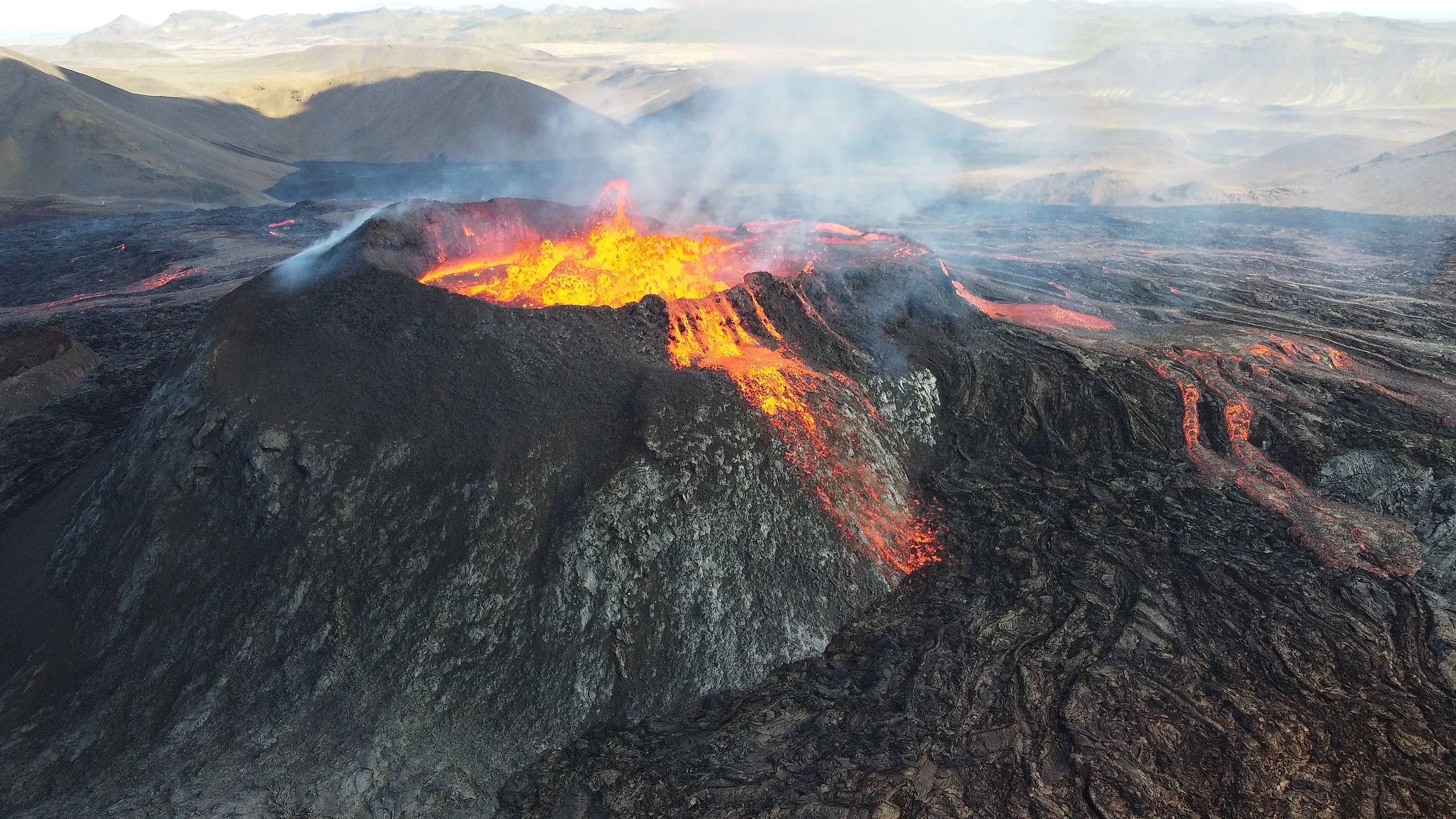
If your definition of the US takes in every state, the last major eruption is almost always a current event. Kīlauea, on Hawaii's Big Island, has been erupting on and off from its summit since December 2024, throwing lava fountains hundreds of feet into the air across dozens of separate episodes. Wind back a few years and the stakes were far higher: Kīlauea's 1983-to-2018 eruption ran for 35 straight years, and its 2018 finale ripped through the lower East Rift Zone, destroying hundreds of homes and swallowing whole neighborhoods. Just upslope sits Hawaii's Mauna Loa, the largest active volcano on Earth, which woke up in late 2022 after nearly four decades of silence.

Then there is Alaska, the real heavyweight. The Aleutian Islands and the Alaska Peninsula form a chain of volcanoes stretching more than a thousand miles that produces eruptions almost every single year, most of them far from any town and noticed mainly by aviators, since drifting ash can wreck a jet engine. Alaska also holds the record for the biggest US eruption in modern history: the 1912 blast at Novarupta, near Mount Katmai, the most powerful eruption anywhere on Earth in the twentieth century, one that dwarfed Mount St. Helens many times over. The bottom line is blunt. If Alaska and Hawaii count, the country almost always has a volcano going.
The Contiguous Answer: Mount St. Helens, 1980
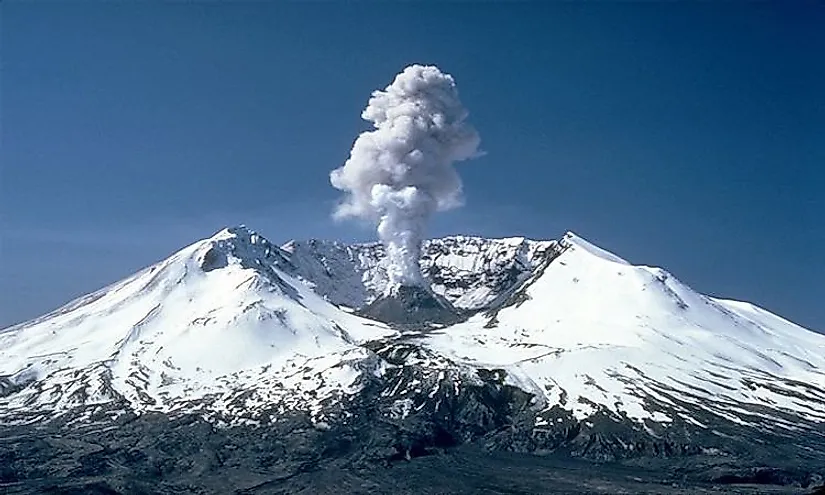
Strip away Alaska and Hawaii and the picture flips. The lower forty-eight had been volcanically silent for so long that when Mount St. Helens, in Washington's Skamania County, began to stir in March 1980, it was the region's first eruption since California's Lassen Peak went quiet in 1917. What came next is still the deadliest and most economically destructive volcanic event in US history, though, notably, not the largest. That title belongs to Alaska's Novarupta.
The warning ran for about two months. A magnitude 4.2 earthquake on March 20 was followed by more than 2,800 tremors and an ominous bulge swelling the mountain's north flank by several feet a day. Then, at 8:32 a.m. on Sunday, May 18, a magnitude 5.1 earthquake shook that bulge loose. The entire north face slid away in the largest debris avalanche ever recorded, and the sudden release of pressure uncorked the superheated gas and dacite magma bottled up inside.
The lateral blast that followed flattened everything in a fan reaching about 19 miles from the crater, roughly 230 square miles of forest snapped flat or seared away. The blast cloud tore outward at speeds up to 670 miles per hour and temperatures above 300 degrees Celsius (570 degrees Fahrenheit). Within 15 minutes, an ash column punched some 80,000 feet into the sky, about 15 miles up, and over the next nine hours it drifted east until midday went dark in Spokane. All told, the eruption released thermal energy estimated at 24 megatons, roughly 1,600 times the energy of the bomb dropped on Hiroshima. It rated a 5 on the Volcanic Explosivity Index, the scale that gauges the force of an eruption (not, as it is sometimes misdescribed, an earthquake) on a run from 0 to 8, where each step up marks a roughly tenfold jump in size.
Aftermath
Fifty-seven people were killed. Among them was USGS geologist David Johnston, who radioed "Vancouver! Vancouver! This is it!" from an observation post six miles away in the seconds before the blast overtook him, and Harry Truman, the 83-year-old lodge owner who had become a folk hero by refusing to leave his home beside Spirit Lake. The eruption destroyed 200 homes, 47 bridges, 15 miles of railway, and 185 miles of highway, and killed an estimated 7,000 large animals such as deer, elk, and bears, along with countless fish and birds. Ash settled across 11 US states and five Canadian provinces. The damage came to about $1.1 billion in 1980 dollars, close to $3.5 billion today. When the mountain finally quieted, it stood 1,300 feet shorter, its summit blasted down from 9,677 feet to 8,364 and replaced by the mile-wide horseshoe crater that shapes its profile now.
So, When Was It?
The next time the question comes up, answer it with a question of your own: which United States do you mean? If it is all fifty states, the last major eruption is essentially ongoing, courtesy of Kīlauea and the restless volcanoes strung along Alaska. If it is the contiguous lower forty-eight, the answer has not moved since May 18, 1980, and it may hold for years yet, right up until one of the other Cascade giants (Rainier, Shasta, Hood, or St. Helens itself) decides it is time to wake up.


