Which Countries Border South Korea?
The only country that South Korea shares a land border with is North Korea. The land border between the two countries is 148 miles in length, dissecting the Korean Peninsula and stretching from the East Sea to the Yellow Sea. This international border is among the most controversial in the world, and is often regarded as the “most dangerous international border on earth.” The border was established in the aftermath of the Korean War of the mid-20th century that resulted in the creation of the two Korean nations of North Korea and South Korea. The border is also known as the Military Demarcation Line and has heavy military presence drawn from the two bordering countries. The bordering countries do not allow cross-border movement on the border, except on a small enclave known as the Joint Security Area. The border is sandwiched by the demilitarized zone, a 2.5-mile wide strip of land that acts as a buffer between the two countries.
The Northern Limit Line
The Northern Limit Line is a delimitation line separating the territorial claims of North and South Korea. It starts on the Han River estuary and extending west into the Yellow Sea. Currently, the demarcation line acts as the only maritime boundary between North Korea and South Korea, albeit in de facto status. The two countries originally had diverging suggestions on the demarcation of the maritime border.
North Korea wanted the demarcation to stretch for 12 nautical miles while the United Nations Command, representing South Korea suggested the length to be three nautical miles. The two parties were not ready to concede their respective claims on the maritime territory in favor of the other, and as a result, the maritime border has never been officially recognized. However, North Korea’s original claim of the delimitation line stretching 12 nautical miles is the internationally accepted definition of the Northern Limit Line. The demarcation line has the islands of Yeonpyeong, Daecheong, and Baecheong being under the administration of South Korea. The navies of the two nations frequently patrol the maritime border, with the North Korean navy escorting fishing boats on the demarcation line. North Korea does not recognize the definition of the maritime border, and the two countries have in history clashed on the Northern Limit Line. The 1999 Battle of Yeonpyeong resulted in the deaths of about 30 people, a violent naval clash that was triggered by North Korean boats crossing the border. In 2010, North Korea’s naval forces bombarded Yeonpyeong and caused widespread destruction in the small island.
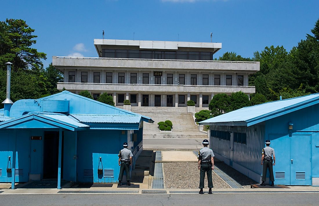
Joint Security Area
The Joint Security Area is a site on the Korean international border, also known as the Truce Village. The area is an enclave covering 2600 feet in width which is considered the sole neutral location on the border and is the only place where the forces of the bordering countries face each other. The area is not controlled by North Korea nor South Korea but is under the control of the United Nations. The site was established in July 1953 in line with the provisions of the Korean Armistice Agreement.
Border Incidents
Countless incidents have been reported on the hostile border, some that have left scores of civilians and soldiers dead from either side of the border. Perhaps the bloodiest of the incidents was the Korean DMZ Conflict of the late 1960s, which were armed conflicts on the border that occurred between 1966 and 1969. During the clashes, North Korea has sent more than 2,400 agents into South Korea, whose mission was to start an insurgency in the country. The violence witnessed during these clashes had been unprecedented since the Korean War, and were therefore sometimes referred to as the Second Korean War. Hundreds of soldiers lay dead in the aftermath of the clashes.
North Korea suffered the highest number of casualties, with about 400 of the country’s soldiers killed, compared to the about 300 soldiers killed from South Korea. The United States had 43 of its soldiers killed. The conflict ended on December 3rd, 1969 but left the delicate diplomatic relations between the two countries in tatters. The two countries have employed numerous hostile tactics along the border ranging from espionage missions to armed attacks. North Korea has been accused of digging tunnels into South Korea, with four such tunnels being discovered since the establishment of the demilitarized zone. South Korea on the other hand, has erected loudspeakers on the border, through which it broadcasts propaganda material against the North.
Bordering Town
Among the few towns situated on the demilitarized zone is Daeseong-dong, a small South Korean town that is the only civilian town in the southern part of the demilitarized zone. Due to its location on the border, the residents of the town are subject to a daily headcount and curfew while visitors are required to have a military escort when visiting the town. An interesting feature of the border town is an ongoing “flagpole war” between the two nations, where they have erected huge flagpoles on their respective sides of the demilitarized zone. About a mile from Daeseong-dong is a bridge that crosses the military demarcation line known as the “Bridge of No Return.” The bridge is so-named as it was historically used for exchanging prisoners between the two countries who were directed never to return to the country in which they were captured. The Bridge of No Return ceased operations in 1976, and almost immediately North Korea built another bridge, “The 72-Hour Bridge” as an alternative.
Countries Bordering South Korea
| Countries Bordering South Korea |
|---|
| North Korea |


