Which Countries Border North Korea?
Where Is North Korea?
North Korea is located in the northern area of the Korean Peninsula in the eastern region of Asia. In addition to its mainland area, this country has several small islands along its western side and primarily concentrated in the Yellow Sea. In addition to this sea, North Korea also has coastlines along the Korea Bay (north of the Yellow Sea) and the Sea of Japan to the east. This country covers an entire area of 46,540 square miles and has a population size of approximately 25.36 million.
The geography of North Korea is diverse, despite its small size. This country is covered by deep river valleys, mountains, plains, and beaches. Because of the rugged terrain and high altitude of the mountains here, the vast majority of the population lives in the plains and valleys. North Korea is also home to a number of rivers, the longest of which is the 490-mile long Amnok River. The territory of this country is bounded by 1,550 miles of coastlines and 1,038.6 miles of international land borders. These land borders are shared with the following countries: China, South Korea, and Russia. This article takes a closer look at each of these international boundaries.
China
The shared border between North Korea and China stretches for a total distance of 880 miles, making it the longest international border in North Korea. It is located along the northern edge of North Korea. Beginning at its westernmost point, this border primarily follows the Yalu River, which is home to a total of 205 islands. The governments of China and North Korea agreed on ownership of these territories by taking a census of the populations here. The islands with populations that identified as historically Chinese ethnicities were given to the territory of China, while those islands with populations of historically Korean ethnicities were given to the territory of North Korea. According to the agreement of 1962, only 78 of these islands belong to China and the other 127 belong to North Korea. In the central region of this international boundary is Mount Paektu. This mountain, which stands at 9,003 feet above sea level and straddles the border, is actually an active volcano. The eastern side of the border between these two countries largely follows the course of the Tumen River.
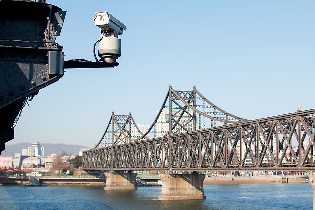
North Korea and China share 3 official border railroad crossings. One of these, known as Dandong, is situated between two cities: Sinuiju in North Korea and Dandong in China. Both of these cities are located along the Yalu River and can be reached by crossing the Sino-Korean Friendship Bridge. This bridge was inaugurated in May of 1943 by the Japanese Army, after 6 years of construction. It is one of the most important routes for trade between North Korea and China and can be crossed by vehicle and train.
South Korea
The shared border between North Korea and South Korea runs for a length of 187 miles along the southern edge of North Korea. This boundary line is considered one of the most dangerous borders in the world due to the political relationship between these two countries. The entire border between North Korea and South Korea is marked by a 2.5-mile wide barrier, known as the Korean Demilitarized Zone. The agreement that established this area, the Korean Armistice Agreement, was signed in 1953 and to prohibit the presence of several kinds of armed military troops and military personnel. Although this agreement was aimed at promoting a more peaceful relationship between these two countries, its boundaries are heavily guarded on both sides. The tensions along this zone have resulted in a number of violent conflicts. In fact, during the first 46 years after the agreement was signed, more than 800 individuals were killed here. Interestingly, a small community has been given permission to remain in this demilitarized zone. Tae Sung Dong, with its population of approximately 218 individuals, was established prior to the Korean War and was, therefore, allowed to stay after the war ended. Representatives of the governments of each of these countries carry out their meetings and negotiations in Panmunjom, a Joint Security Area. This Joint Security Area is located near the western coast of the Korean Peninsula. Until 2007, this was the only location where the two governments were able to get together and they only way these two countries were connected. The Donghae Bukbu rail line connecting North and South Korea was opened in 2007, but after a violent incident in 2008, it was permanently closed down. Since then, these two governments have once again relied on the Joint Security Area. Even this protected location has been witness to a number of violent encounters over the years.
Russia
The shared border between North Korea and Russia runs for a total of 10.9 miles over land, making it the shortest international border of North Korea. This boundary, which is situated along the northeastern edge of North Korea, extends into the Sea of Japan for around 12 nautical miles as well. The border between these two countries was agreed upon in April of 1985 and geographically, it follows a small section of the Tumen River and its estuary out into the Sea of Japan. At its northernmost point, the border between North Korea and Russia begins where the border of China ends. This point, known as a tripoint, is technically located in the middle of the Tumen River. In order to maintain a clear definition of this tripoint, the governments of each country agreed to install a border marker along the bank of the river. North Korea and Russia are connected by one border crossing, known as the Friendship Bridge. This bridge is only designated for railway travel, although some small, temporary changes have been made in the past to allow private vehicles to cross. Both cargo and passenger trains may cross between these two countries. The governments of both countries have, however, made an agreement to build a roadway across this border to make travel easier.


