Which Countries Border Norway?
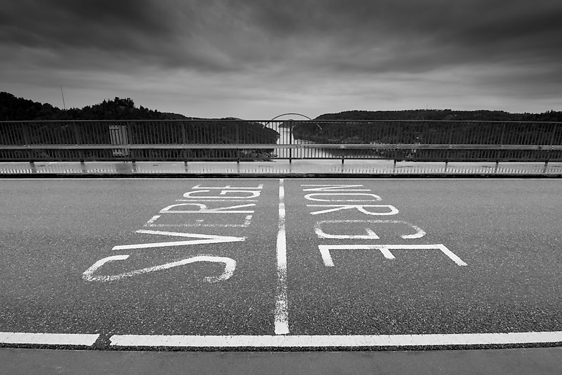
Norway has a land border that stretches 1,568 miles long. The country shares its land border with three countries; Sweden, Russia, and Finland where Sweden shares the longest portion of the border, while Russia shares the shortest. Except for the country’s border with Russia, Norway’s land border is under the Schengen Area which is characterized by the absence of border controls. Most of the border’s length is defined by mountains like the Scandinavian Mountains, and the natural courses of rivers such as the Jakobselva, Tana, Pasvikelva and Anarjohka River.
1. Norway-Sweden Border
Of the three countries sharing a land border with Norway, the Swedish border is the longest as it is about 1,010 miles in length. The tri-point connecting Sweden, Norway, and Finland at Treriksroysa is the starting point, from where it runs southwards until it reaches the North Sea. Along its length, the border is crossed or follows several rivers and lakes, following the Scandinavian Mountains’ drainage divide. Six counties in Sweden touch the border, and they are Norrbotten, Vasterbotten, Jamtland, Dalarna, Varmland and Vastra Gotaland. Norway has seven counties that touch the border.
Norway-Sweden Border Crossings
The two countries are signatories of the Schengen Agreement that provides for the Schengen Area and so have no border controls on the border. However, with Norway not being part of the EU, the border has customs stations. The border has four railways crossings, each of them having a single rail track. Four border stations exist at the point at which the railways cross the border; Storlien, Charlottenburg, Riksgransen, and Kornsjo. Both freight and passenger trains are served by all four railways. There are ten road border crossings each having customs stations. Two of the road crossings (Orje/Han and Svinesund) have customs stations operated by both Sweden and Norway. An additional 30 roads cross the border but have no customs stations. Heavy trucks are barred from using these roads without having pre-declaration. To monitor the activities on these roads numerous video surveillance checks have been set up on the crossings.
History of the Norway-Sweden Border
Several treaties were signed by the two countries in the 17th century, concerning the border, including the 1645 Treaty of Bromsebro, 1658 Treaty of Roskilde, and the 1660 Treaty of Copenhagen. The 1645 treaty saw the four parishes in Norway (Bohuslan, Idre, Jamtland, and Harjedalen) being transferred to Swedish territory. The 1751 Treaty of Stromstad saw the demarcation of the border, after years of surveys and local consultations on both sides of the border. Negotiations between the two countries concerning the division of parishes that stood along the border were handled between 1738 and 1751. Disputes arose in the positioning of the Kautokeino, Idre, Lierne, Karasjok, and Sarna parishes on the border, but they were later diplomatically solved. In uninhabited remote mountainous regions, the border was to follow the water divide. The 19th century saw the establishment of the union of the two countries as a result of the 1814 Treaty of Kiel. The union stood for about nine decades until it was dissolved in 1905 after the Karlstad Negotiations. Norway was occupied by Nazi Germany during the Second World War, a move that saw thousands of Norwegians fleeing across the border into Sweden as refugees.
2. Norway-Finland Border
The Norway-Finland land border is 457 miles in length, and starts at the tri-point connecting Norway, Sweden, and Finland, and extends east to the Russia-Norway-Finland tri-point. A stone cairn named Treriksroset represents the westernmost point of the border, while the Treriksroysa stone cairn represents the border’s easternmost point. About 230 miles of the border follows the courses of the Tana and Anarjohka rivers.
History of the Norway-Finland Border
The border was established in 1751 through a treaty signed by Norway, Finland, and Sweden, after 13 years of deliberations and field investigations. Soon after the border’s establishment, it was demarcated by erecting cairns along the border. Both Norway and Finland are part of the Schengen Agreement, whose provisions instruct the removal of border patrols along the border, provisions the two countries have complied with, and there are six road border crossings found on the border, all having custom stations administered by either country.
3. Norway-Russia Border
Norway shares a land border with Russia that is 121.6 miles long, the shortest land border Norway shares with another country. Besides, the two countries share a maritime border that is 14.4 miles long. The Norway-Russia border is the country’s youngest border as it was established in 1826. A total of 415 markers are found on the Norway-Russia border, most of which are made out of composite materials. Norway’s border markers are yellow while the Russian markers have red and green horizontal stripes. The maintenance of the markers is the responsibility of the respective country. The Norwegian side of the border is patrolled by conscripts from the Garrison of Sor-Varanger, while Russia’s side is patrolled both by the Federal Security Service and the Border Guardian Service of Russia. Only one legal border crossing is found on the Norway-Russia border, situated along the E105 highway and connecting the Russian town of Borisoglebsky to Norway’s Storskog town. The two countries have customs and immigration stations at this border crossing point.
History of Norway-Russia Border
Initially, there was no border separating Norway from Russia. The two agreed in 1326 to establish a march along the current border, in Finnmark and the Kola Peninsula, where double taxation was done both by Russia and Norway. The need to delineate a border separating the two kingdoms arose in the 16th century after Russia encroached on the marchland and built several religious structures in the Sami. Norway would later surrender all claims to Finnmark in the early 17th century, in line with the 1613 Treaty of Knared. The late 17th century saw Norway formally request for the delineation of the border, but Russia’s input in the matter was not forthcoming. A commission with members drawn from both countries was instituted in 1825, whose mandate was the demarcation of the border. The border was finally established in a treaty signed on May 14, 1826. The border went through a series of revisions in the late 19th and early 20th centuries.