Which Countries Border Namibia?
Namibia is a large African country that is situated in the southern part of the continent. With a population density of only seven people per square mile, the country has the lowest population density in Africa and the second-lowest in the world behind Mongolia. The low population density is attributed to the harsh weather conditions experienced in most parts of the country which make basic agriculture nearly impossible. Two of Africa’s largest deserts, the Kalahari and the Namib deserts are situated in the country. The country’s land border stretches a total length of 2,445.7 miles and is shared with its bordering countries which include South Africa, Botswana, Angola, and Zambia. The longest of Namibia’s four international borders is the Namibia-Angola border which is 855 miles in length while the shortest is the Zambia-Namibia border which stretches 144 miles in length. Part of Namibia’s land border is marked by the course of rivers including the Okavango River (the Namibia-Botswana border) and the Cunene River (the Namibia-Angola border).
Botswana
Botswana borders Namibia to the west. The two countries share a long land border. The border starts at the tripoint connecting the two countries to South Africa, from where it moves north then east until it ends at the South Africa-Namibia-Botswana border. The entire stretch of the border measures 845 miles in length, making it the second-longest of Namibia’s international borders. Like all of Namibia’s borders, the country’s border with Botswana was first established during the establishment of European colonies in the continent during the Scramble for Africa in the later 19th Century. Both Namibia and Botswana would inherit the colonial delineation of the border after the two countries gained independence in the second half of the 20th Century.
The Okavango River
The Okavango River is notable for marking a significant portion of the Namibia-Botswana border. Despite representing the border separating the two nations, the river has been a polarizing and sensitive issue which has, in the past threatened to escalate to a diplomatic conflict between Botswana and Namibia. The reason behind the dispute is that the two countries experience extended dry periods with low rainfall and so rely on the Okavango River for their water demands. Namibia had resolved to build a major pipeline which would be over 100 miles long aimed at harvesting water from the river. The pipeline’s proposal came after the country had already built a longer canal which also tapped water from the Okavango River. Botswana whose chief revenue earner, the Okavango Delta, is situated further downstream was uncomfortable with Namibia’s intention to build the pipeline, claiming that such a project would exert more pressure on the river. However, Namibia was relentless in its resolve to build the pipeline, stating that it intended to harvest only 1% of the river’s flow.
Border Crossing Points
Cross-border movement on the Botswana-Namibia border is only allowed on the four border crossings established along the border. Two of the crossing points are popular and facilitate the movement of thousands of people across the border each year, and these are the Ngoma-Mohembo and the Momuno-Buitepos crossing points. Both crossing points are found in remote parts of the border and, therefore, they lack basic infrastructure. The border crossing points are patrolled by immigration officials from Namibia and Botswana who require people to produce necessary documents to be granted permission to cross the border. Among the required documents at the border crossings are the cross-border permit and a valid passport.
South Africa
Namibia is bordered to the south and southeast by South Africa. The two southern African countries share a long land border that stretches for 601 miles. A considerable stretch of the land border follows the course of the Orange River. The border starts at the mouth of the river on the Atlantic Coast and moves eastwards and upon meeting the 200 east latitude, moves northwards until finally ending at the tripoint where the two countries connect to Botswana.
History
For centuries, no border existed to separate the two countries as they also did not exist. Indigenous tribes that lived on either side of the current border subsisted on a nomadic lifestyle that involved hunting and gathering. These communities include the modern Khoisan people who reside in southern Namibia and northwestern part of South Africa. The border separating South Africa from Namibia was first demarcated during the late 19th Century when European powers came to the continent to establish colonies. Namibia was carved out as a German colony (German South-West Africa) while South Africa was established as a colony of Great Britain. However, the two European colonial powers regularly clashed over the demarcation of the border separating the two colonies. In 1890, the two colonial powers came together to sign the Heligoland-Zanzibar Treaty which explicitly dictated the delineation of the international border.
The Border Post-Independence
Namibia would cease to be a German colony in the aftermath of the First World War when the colony was invaded and conquered by neighboring South Africa. The two countries would retain the demarcation of the border as defined in the colonial treaty even after attaining self-rule in the late 20th Century. The only exception was an exclave of South Africa at Walvis Bay whose sovereignty was transferred to Namibia after South Africa gained independence in 1994. However, the two countries are yet to agree on the definition of the border along the Orange River. Namibia recognizes that the border is situated at the center of the river while South Africa’s definition claims that the river’s northern bank marks the international boundary.
Border Crossing Points
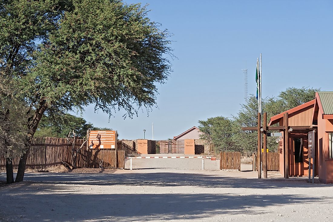
The border separating South Africa from Namibia runs along a remote part of the continent which experiences harsh climatic conditions. Therefore, settlement along the border is sparse or, in most cases, absent. Nonetheless, the border is extensively patrolled by security agents drawn from the two bordering nations. There are a few border crossing points found on the border where cross-border movement is allowed and facilitated by immigration and custom officials from Namibia and South Africa. Two of the border crossings are situated on wildlife parks which straddle across the border and are exclusively used by tourists. These exceptional crossings are the Sendelingsdrif and the Mata Mata-Welverdiend crossing points.
Which Countries Border Namibia?
| Countries Bordering Namibia |
|---|
| Angola |
| Botswana |
| South Africa |
| Zambia |


