The Most Extreme Points of Iran
Iran is a republic on the Persian Gulf. The country covers a total area of 636,372 square miles. The topography of Iran is characterized by rugged, mountainous regions surrounding elevated interior basins. There are series of ranges with the Zagros Mountains as the main feature and a chain of ridges that bisects Iran from northwest to southeast. The central plateau is at the center of the second largest country in the Middle East. To the Northwest are Armenia and Azerbaijan while the Caspian Sea borders Iran to the north with the Gulfs of Persia and Oman to the South. Iran borders Pakistan and Afghanistan to the east and Turkey and Iraq to the west. The country is divided into five regions which are further subdivided into 31 provinces. However, there are several extreme ends of the country as detailed below.
6. Northernmost Point in Iran
Cheshmeh Soraya area of Kukh located adjacent Mount Ararat foothills is the northernmost location in Iran. It is located in West Azerbaijan Province at 39°44’55”N 44°37’26”E coordinates. The snow-capped mountain of Ararat is a dormant volcano and the most notable feature of the area. The mountain extends into and has its peak in Turkey. The foothills give early risers a clear view of the beauty of Ararat Mountain during summer. Ararat foothills extend into the interior of Iran and are a source of some rivers while Mining efforts are at advanced stages along the foothills.
5. Southernmost Point in Iran
Pasabandar is a rural center in Chabahar County of Sistan and Baluchistan province. According to a census carried out in 2006, the population of the rural center is 696 people making up 109 families. Pasabandar is the southernmost town in Iran. The town is located at 25°4’1”N 61°24’44”E coordinates and is near the border of Iran and Pakistan. The Arabian Sea to the south of the town. However, the man-made port known as the Chabahar Port on the Gulf of Oman inaugurated in 2017 is set to be the southernmost point in Iran when completed. The seaport will be the closest link of Iran to the Indian Ocean.
4. Westernmost Point in Iran
The westernmost point in Iran is known as Bazargan. The region of Bazargan District of Maku County in the west of Azerbaijan province is on the border with Turkey near the town of Gurbulak. The population which derives a livelihood from mostly trading was estimated to be slightly above 9,000 according to 2006 census. It is an important Centre for Iran in terms of imports and exports. The border city has the immigration offices where any person entering Iran has his visa checked. Bazargan has modern amenities and infrastructure hence a great tourist attraction site. Modern world-class hotels and restaurants are available as well as an efficient transport system.
3. Easternmost Point in Iran
Kuhak is the easternmost point in Iran. The village is located in Bam Pasht District in the Saravan County in the Sistan and Baluchestan province. Bam Pasht District has only one city and several settlements and villages. Kuhak is the closest region to Pakistan with Road 92 passing through the village. As at 2006, there are 9,267 people living there. The rural district is located approximately 863 miles south-east of Tehran the capital city of Iran.
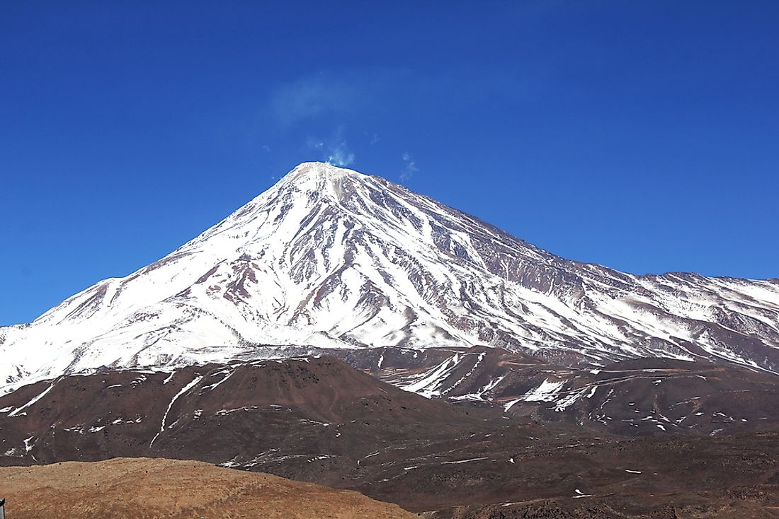
2. Highest Point in Iran
Mount Damavand is the highest point in Iran. It is also the highest volcanic feature in Asia at 18,403 feet above the sea level. Mount Damavand is also ranked 12th highest point in the world and the second prominent peak in Asia after Mount Everest. Located in Amol County, Mazandaran province, the mountain is regarded as an iconic feature in the Persian mythology and folklore, symbolizing Iranian resistance to the foreign rule and despotism. Geologists estimate that the volcano may have first erupted in the Pleistocene more than 1.78 million years ago with the last eruption taking place around 5300 BC. Its steep cone is made of ash and lava with the major components being trachyte, basalt, and andesite. Mineral deposits, as well as hot springs, are also found on the Mountain. Geologists consider Damavand as a potentially active volcano due to the presence of Sulfur emitting fumaroles in the summit crater. The mountain is part of the Volcanic Seven Summits mountaineering challenge.
1. Lowest Point in Iran
The Caspian Sea is the lowest point in Iran at 28 meters (92 feet) below the sea level. Located in the Caspian Depression, Caspian Sea is on the east of Caucasus Mountains. The point is so low that in the southern region the sea is at 3,356 feet below sea level, making it the second lowest depression in the world after Lake Baikal. The Caspian Sea accounts for between 40 % and 44% of the lacustrine waters of the earth. The sea can be divided into three regions namely the northern, southern, and the middle. The three regions have distinct characteristics because the north is very shallow at only 16 to 20 feet. The middle has an average depth of 620 feet while the southern side is deeper than 3,300 feet and accounts for the largest percentage of water. The sea is so low that over 130 rivers flow onto it. There are numerous islands near the coastline. The Caspian Sea covers an area of approximately 143,200 square miles and has a volume of 18,800 cubic miles. The sea derived its name “Caspian” from the ancient Caspi people who lived around the sea.


