The Most Extreme Points of Germany
Germany stretches from the Alps to the North Sea and Baltic Sea across the North European plains. It is the second largest country by population after Russia and the 7th largest in the continent by total area, covering approximately 137,847 square miles of which 134,836 square miles is land while the rest is water. The elevation of Germany ranges from the Alps in the south to the North Sea and that of Baltic Sea in the northwest and northeast respectively. Between the points lie uplands that consist of forests in central Germany and low-lying plains in the north. This article focuses on the extreme points of Germany, their location, characteristics, and any important or unique features.
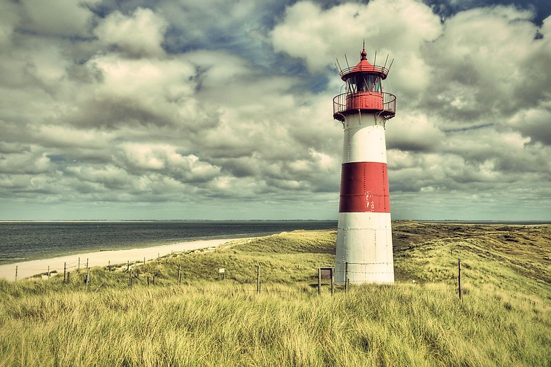
6. Northernmost Point in Germany
The northernmost location of Germany is the List Auf Sylt, simply known as List. It is Germany’s northernmost municipality situated on Sylt Island on the North Sea. The village is close to the Danish district of Nordfriesland and is surrounded by dunes and heaths that are protected nature reserves.Initially, List was a Danish settlement. The settlement was destroyed by a great flood in 1364 but the settlement was rebuilt a few miles away from the previous location on the east. During World War I, List was a naval base and was an important training location for the military. Most of today’s development in List took place in the 1930s when Nazis added more houses for the military. The military has since been withdrawn from the area and the attention is now focused on tourism. List has a population of approximately 2,700 people, of which only 1,600 are permanent residents. The others are mainly owners of holiday homes who visit the place to supervise their businesses.
5. Southernmost Point in Germany
The southernmost point in Germany is in Haldenwanger Eck which is a pass in the Alps. The name is derived from Old High German word “halda” meaning hillside and “wangs” meaning climb. Haldenwanger Eck is located on Germany’s border with Austria, forming the border triangle of Bavaria-Tyrol-Vorarlberg near the district of Oberallgau in the municipality of Oberstdorf. Haldenwanger Eck is on the upper reaches of Stillach, about 4 kilometers west of Biberkopf which is sometimes referred to as the southernmost point in Germany. Haldenwanger Eck can only be accessed through mountain tour since it is a saddle between high mountains. Residents can also use motorized vehicles to access the location. German’s southernmost state office is located at the boundary stone 147 southeast of Haldenwanger corner. A granite column with inscriptions was built in 1986 to act as a landmark. Hamlet Einodsbach, Germany’s southernmost town, is located about 8 kilometers northeast of Haldenwanger Eck.
4. Westernmost Point in Germany
The village of Isenbruch is the westernmost point in Germany. The village is located in Selfkant, approximately 17 kilometers southwest of Heinsberg on the German’s border with Dutch. Germany’s westernmost state office is located approximately 1.4 kilometers northwest of Isenbruch, on the county road K1. The village changed its name several times over history. Some of the names used to refer to the village include Ysenbruic, Ysenbroeck, ingen Isenbroich, and Isenbroich.In the 14th century, the land near Isenbruch was owned by Heinrich von Hongen while the village itself belonged to the Julich Office Millen. The village had a court and a parish resident. Between 1949 and 1963, Isenbruch was under the Dutch administration. One of the village’s most outstanding feature is the St Gertrude Havert, a Roman Catholic Church which dates back to the early 16th century. Administratively, Isenbruch is represented by a mayor. As of 2013, the population of the town is approximately 325 people.
3. Easternmost Point in Germany
The easternmost point in Germany is located within Neißeaue municipal limits including Deschak. Before World War II, the easternmost location in Germany was a village in East Prussia known as Schirwindt. Deschak is located approximately 7.5 kilometers northeast of Neißeaue city center. Neißeaue is located in the district of Gorlitz close to the border with Poland. It is in the wooded area of Neisse valley and comprises of areas such as Deschka, Zodel, and Zentendorf. Most of the eastern villages Germany lie between Deschka and Zentendorf. The largest district in Neißeaue is Zodel with a population of approximately 600 people. Deschka, which is where the easternmost point is located, is the third largest district with a population of approximately 300 people. The major economic activity in Deschka is mainly exploratory drilling with possible copper mines.
2. Highest Point in Germany
The highest point in Germany is Zugspitze peak at 9,718 feet above the sea level. Zugspitze is the highest peak of the Wetterstein Mountain. It lies on the German-Austria’s border in the town of Garmisch-Partenkirchen, Southern Germany. The exact height of the mountain was a subject debate for sometimes with the figures ranging from of 8,830 to 9,740 feet. However, it is now generally accepted that it is 9,718 feet. Zugspitze had three peaks until 1930 when the middle summit disappeared following the installation of cable car summit station. The west summit was blown out in 1938 to create room for the construction of a flight control room. However, the control room was never built. Because of soil conditions, the flora of Zugspitze is limited while the surrounding vegetation is mainly colorful. The mountain lies within the temperate zone and is often frozen 310 days per year.
1. Lowest Point in Germany
There are two lowest points in Germany; man-made and natural. The easternmost man-made location is Tagebau Hambach at 961 feet below the sea level. The open-pit coal mine is located Niederzier and is used in mining lignite. The mine operation in the area began in 1978 and currently covers an area of approximately 39 square kilometers. The area designated for mining is 85 square kilometers. Tagebau Hambach is on the site of the ancient Hambach Forest. Tagebau Hambach is the deepest open-pit mine with respect to the sea level.The lowest natural point in the country is Neuendorf-Sachsenbande which is a municipality in Wilstermarsch. The lowest accessible point in the town is 11.61 feet below the sea level. The municipality is largely rural with agriculture as the main activity.


