The Biggest Islands Of Tonga
Tonga, officially known as the Kingdom of Tonga, is a sovereign state that is made up of 169 islands in the South Pacific Ocean. It covers a total area of slightly more than 750 square miles. Tonga covers a stretch of land that is approximately 500 miles. It borders Fiji to the northwest and Samoa to the east. To the east, it borders Niue and New Caledonia to the west. The state has a population of 103,000 people residing in 36 of the 169 islands, the majority of the population live on the island of Tongatapu. It is a constitutional monarchy headed by a king who is the head of states and also the commander in chief. The king appoints the prime minister from the members of parliament with the majority members of Parliament. Tonga offers free education for its citizens and scholarships to pursue higher educations in other countries. The country’s economy depends on foreign remittance mostly from Australia, United States and, New Zealand. Majority of the population is employed in the agricultural sector. Rugby has been largely accepted as the main sport in the country, and Tonga's rugby team has been made famous due to several major victories in international competition.
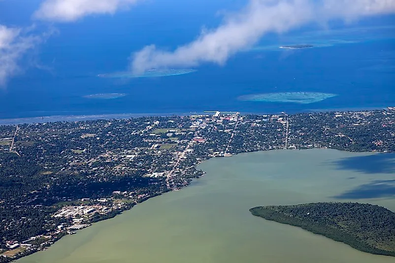
Tongatapu
Tongatapu is Tonga's main island. The island is located in the southern group of islands. Nuku’alofa, Tonga's capital, is also located on Tongatapu. It is the most populous island with more approximately 72,000 inhabitants representing 70.5% of the total population. The island covers approximately 100 square miles and lies 215 feet above the sea level. The island is a commercial hub that has experienced better economic development than other islands in the country. The island is relatively flat with thick, fertile, volcanic soil. At the northernmost end of the island, several small islands, and coral reefs extend 4.2 miles from the shore. The island experiences a cool climate which leads to reduced fruit production in the region. Tongatapu has a high concentration of archaeological artifacts. The Europeans first visited the island in 1643, in 1977, Captain James Cook introduced cattle to the island.The islands key attraction sites include the Langi, the flying fox preserve, and the Nukuleka.
Utu Vava’u
The island of Vava’u is made up of one large island surrounded by 40 smaller islands. The island stretches 13 miles from east to west, and 15.5 miles from the northernmost part of the island to its southernmost point. It covers 37 square miles, and has approximately 15,000 inhabitants, of which 5,000 live in Neiafu, its own capital city. The island is approximately 430 feet above sea level at its highest point, Mount Talau. The island is made up of coral reef that is oblique to the north and spreads up to make several islands to the south. The climate is warmer than the rest of the country, resulting in high production of vanilla and pineapples in the region. It is a picturesque island that is popular with sailors and tourists. From May to October, the island hosts thousand of boats that journey to the port of ’Utu Vava’u to view the migration of whales. Traditional myths claim that the gods fished in the island, and god Maui caught the seabed his hook and fished it up resulting in the emergence of the island.
Eua
The island of Eua is one of the smaller major islands of Tonga. The island covers an area of 33.76 square miles and as at 2011, the population was slightly more than 5,000. The island is hilly and with the highest point, the Funga Te’emoa being 1,024 feet above sea level. In contrast to many of the other islands in the country, it was not formed through volcanic processes. Instead, it was formed due to the rubbing together of tectonic plates, which left a 4.4-mile deep trench at the bottom of the sea. It is the only island with a river in the country; the river drains its water to a harbor in the capital city of the island, Ohonua. A unique feature, the coral reef close to the sea level is found between Ohunua and Tufuvai. Six villages are found in the northern part of the island while nine are found in the southern regions. Due to its terrain, the island is a popular destination for tourists seeking outdoor adventures. It offers camping sites and hill climbing expeditions.
Niuafoʻou
The island of Niuafo’ou is the northernmost major island in Tonga. It is a volcanic island covering an area of 5.8 square miles. As at 2006, the island had 650 inhabitants. The island is considered an active volcano that faces the threat of a volcanic eruption. In 1853, 25 people were killed and a village destroyed when lava flow swept through the village of Ahau. Other violent eruptions had occurred as recent as 1946 when the government was forced to evacuate the whole population. The island has a lake in the that lies 14.3 miles above the sea level; it is 2.5 miles wide and 52 miles deep. It has a steep rocky coastline with a few sandy beaches. Communities and residential habitats are located in the northern and eastern parts of the island. According to the traditional myths, a mountain once stood where the lake exists, but it was stolen a huge hole was left behind.
Rising Sea Levels Threaten Tonga
Tonga is facing the threat of rising sea levels. The rate of the rising sea is threatening to submerge some of the country’s islands. In 2000, Cyclone Waka destroyed hundreds of home and left multiples dead. Active volcanoes are also threatening the country, with some of the islands being active volcanoes, eruptions could result in loss of habitat and life. In March 1985 the country experienced some of the worst volcanic eruptions. Westernization has led to the adoption of western culture and resulted in the erosion of native culture. Increases in population are also stretching the available resources, resulting in poor social welfare and a shortage of available amenities.
The Biggest Islands Of Tonga
| Rank | Biggest Islands in Tonga | Area |
|---|---|---|
| 1 | Tongatapu | 100.6 square miles |
| 2 | ’Utu Vava’u | 37 square miles |
| 3 | Eua | 33.8 square miles |
| 4 | Late | 10.9 square miles |
| 5 | Niuafoʻou | 5.8 square miles |
| 6 | Foa | 5.2 square miles |
| 7 | Lifuka | 4.4 square miles |
| 8 | Pangaimotu of the Vavaʻu Group | 3.5 square miles |
| 9 | Nomuka | 2.7 square miles |
| 10 | Tafahi | 1.3 square miles |


