Biggest Islands In Mauritius
The main island of Mauritius covers 92.5% of its namesake country's land area, and also houses Port Louis, the nation's capital and largest city. Mauritius Island is the main island and is part of the Mascarene Islands, as is Rodriguez Island. Rodriguez is the second biggest island in Mauritius with an area of 42 square miles, and the twin islands of Agalega follow with a combined land mass of around 9.3 square miles. Ile Aux Cerfs is a privately owned property that offers luxurious beaches and a golf club where many Mauritians and other visitors tour every day.
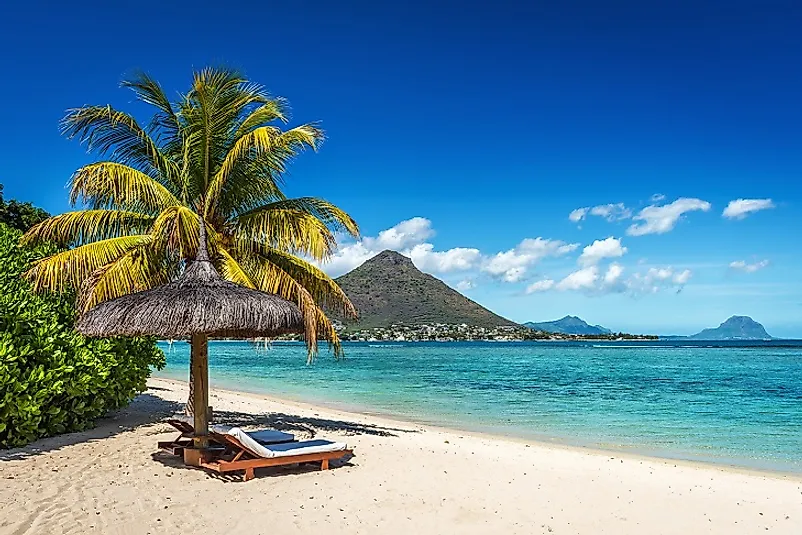
Mauritius Island
The biggest island in the country is Mauritius Island with a total land area of 718 square miles, covering 92.5% of the country. The island lies some 1,242 miles off the coast of Africa. Mauritius Island has 93 miles of sandy beaches surrounding it, and the coral reefs protect the lagoons from the open seas. Geographically the Island is around 8 million years and forms part of the Mascarene Islands. These islands emerged from abysses when volcanic actions took place underwater. A broken ring of mountain ranges with elevations of 300 to 800 meters above sea level surround Mauritius Island. The land mass rises from the coastal plains and at the height of 670 meters, a central plateau forms. Piton de la Petite Riviere Noire which stands at 2,717 feet is the highest point on the island. Many rivers and streams also flow through the island most of them formed by the action of the lava flow. Current environmental threats include water pollution and degradation of coral reefs. Cyclones that hit the land from November to April could pose as hazards especially since the island has the largest reef in the world.
Rodriguez Island
Rodriguez is a 42 square-mile autonomous outer island, and the second largest in the Island nation of Mauritius. Similar to the main island of Mauritius, Rodriguez is part of the Mascarene Islands the other being Reunion. The coast is characterized by creeks, sandy beaches, and coral reefs, surrounded by small islets. Before becoming autonomous on December 10, 2002, the island served as the tenth District of Mauritius. The Rodriguez Regional Assembly governs the island while Port Mathurin serves as the capital. The Statistics of Mauritius show that as per 2014 there were around 41,669 inhabitants of mixed African and French descent. The primary economic activities are farming, fishing, handicraft, and tourism. Before the 17th Century, the island provided habitats to many plant and animal species which have been eradicated. For example, Rodriguez Solitaire (Pezophaps solitaria) a flightless bird is now extinct. The Rodriguez flying fox an endemic species is listed by the International Union for the Conservation of Nature (IUCN) Red List as critically endangered. To restore some of the plant life that has been lost, the government has declared certain forests areas as nature reserves. These include Ile aux Cocos, Sables, Grand Montagne, and Anse Quitor.
The Agalega Islands
The Agalega Islands, lying 620 miles north of Mauritius Island, are two islands in the Indian Ocean. The North Agalega has a land area of 3.4 square miles while the South Island is 5.9 square miles. North Agalega houses the capital Vingt Cinq and the island’s airstrip while Ste Rita is the only village in South Agalega. A 1.5-kilometer-long stretch of sand separate the two islands, and residents must wait for the high tides to cross from one side to the other. Sand tracks constitute the main road tracks. From afar, the island appears as a green jewel in the middle of an ocean. The endemic plant is coconut and Agalega Island Day Gecko is a native species. The islands produce and export coconut oil and copra. The residents also keep poultry, cattle, and practice the cultivation of vegetables for subsistence. Around 300 residents are living in both islands, and until recently, there was no money circulation, and the people depended on government vouchers for survival.
Ile Aux Cerfs
Ile Aux Cerfs is a privately owned island lying east of Mauritius Island in the Flacq District. The island lies in the largest lagoon of Mauritius and has more than 0.46 square miles of vegetation and preserved white sandy beaches. Tourists visiting the island use boats to cross from the Trou d’Eau Douce. There are also many water sports in the isle, and together with the Aux Cerfs Golf Club, and Beach restaurant, the small island offers luxury beyond measure.
Territorial Disputes
Mauritius and Seychelles have often disputed over the Chagos Archipelago, which lies 1,287 kilometers northeast of Mauritius Island, for a long time. The Archipelago served as an official part of Mauritius as early as the 18th Century when the first French settlers settled in the Country. The United Kingdom on November 8, 1965, split the Chagos Archipelago from Mauritius alongside Seychelles islands of Aldabra, Desroches, and Farquhar to form the British Indian Ocean Territory. Chagossians and the country of Mauritius have since engaged in activism and campaigns to have the archipelago returned to Mauritius since Chagos is an integral territory of Mauritius under the Mauritian Law and International Law. Mauritius also disputes with France over Tromelin Island which lies around 430 kilometers northeast of Mauritius.
Environmental Threats
Mauritius is a tropical island nation in the ocean, and dense forests covers much of its mountainous area. Seasonal cyclones destroy flora and fauna of the Islands although they quickly recover. Human habitation and the introduction of invasive species threaten the integrity of the country’s biodiversity. Over 100 plant and animal species are now extinct and more are endangered. Conservation efforts in the country include the reproduction of the threatened bird and plant species and habitat restoration in the form of national parks and nature reserves.
Biggest Islands In Mauritius
| Rank | Major Islands of Mauritius | Land Area |
|---|---|---|
| 1 | Mauritius | 718 square miles |
| 2 | Rodriguez | 42 square miles |
| 3 | South Agaléga | 5.9 square miles |
| 4 | North Agaléga | 3.4 square miles |
| 5 | Ile Aux Cerfs | 0.46 square miles |
| 6 | Albatross | 0.39 square miles |
| 7 | Ile aux Benitiers | 0.27 square miles |
| 8 | Coco | 0.19 square miles |


