Baltic Sea
The Baltic Sea is one of the seas of the Atlantic Ocean. It is the ocean’s 15th largest sea, covering an area of approximately 377,000 km2.The sea is approximately 1,600 km long and 193 km wide and has a water volume of about 21,700 km3. The Baltic Sea is connected to the White Sea via the White Sea Canal and to the North Sea’s German Bight via Kiel Canal.
The Baltic Sea is often cited as the world’s largest brackish inland water body. Its water salinity levels are lower than that of the World Oceans due to the inflow of fresh water from the surrounding land and the sea’s shallowness. Its depth averages 55 meters and the deepest part is approximately 459 meters below the sea’s surface.
Contents:
Where Is The Baltic Sea?
- Origin Of The Name
- Rivers Draining Into The Baltic Sea
- The Climate Of The Baltic Sea
- Islands In The Baltic Sea
- Marine Life And Protected Areas
- Brief History
- Human Settlements Along The Baltic Sea
- Economy
Where Is The Baltic Sea?
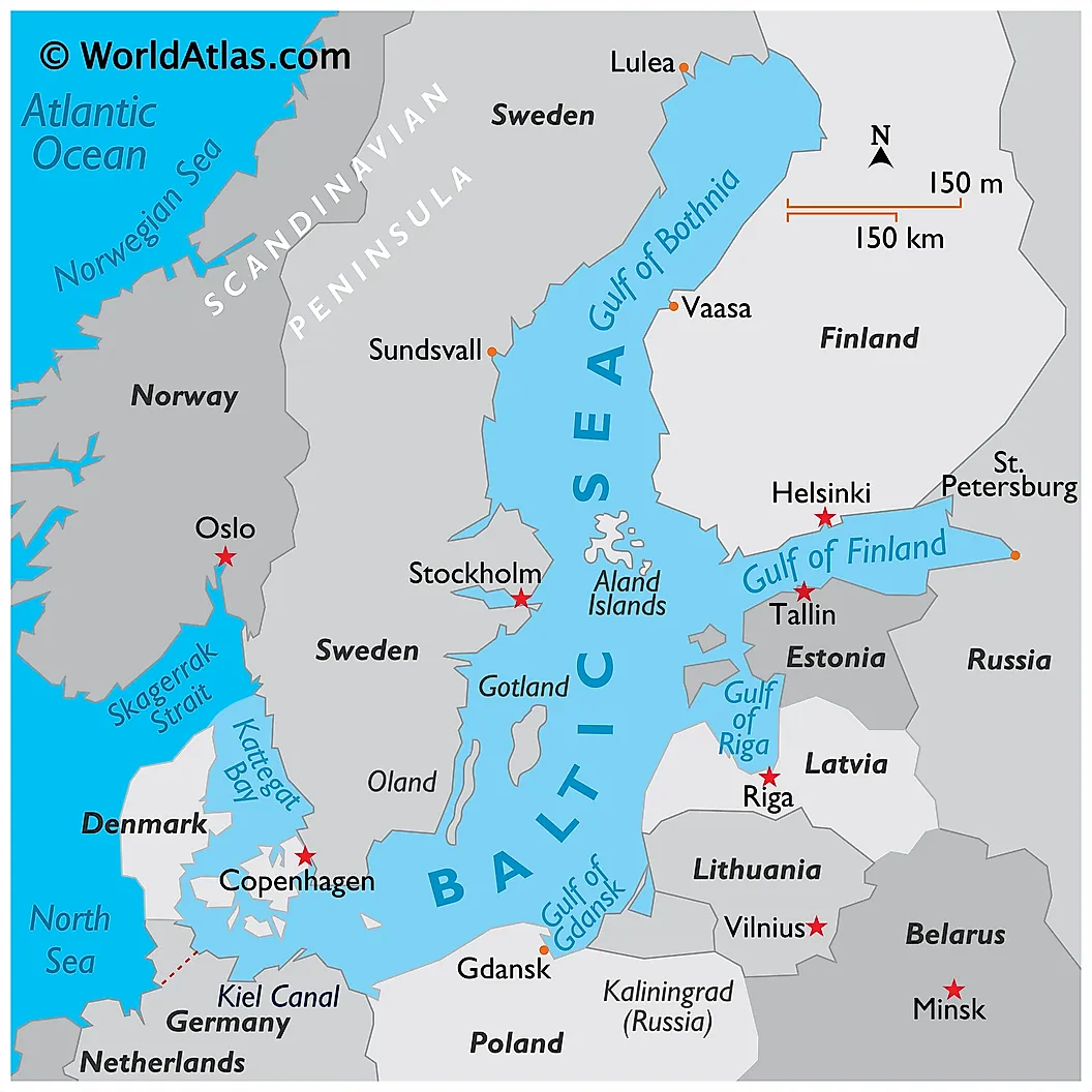
The Baltic Sea is part of the North Atlantic Ocean, situated in Northern Europe. It has a coastline of approximately 8,000 km, shared by several countries, including Sweden, Poland, Lithuania, Latvia, Finland, Estonia, Germany, Denmark, and Russia. The Baltic countries share the southeast coastline while the North European Plains are on the southwest. Denmark and Sweden border the sea to the west, while Finland is on the northeast. It drains into the Kattegat via the Danish Strait and covers a catchment is of approximately 1.64 million km2.
The Baltic Sea is subdivided into several regions. The Gulf of Bothnia (including the Bothnia Bay) is on the northern part. The Bothnia Sea forms the gulf’s southern basin. Below the Bothnia Sea is the Aland Sea, connecting the Bothnia Sea to the Baltic Sea proper. The Baltic Sea is connected to St. Petersburg by the Gulf of Finland. The Gulf of Riga is located between Estonia and Latvia. On the South of the Baltic Sea are the Bay of Gdansk, Arkona Basin, and the Bornholm Basin.
Origin Of The Name
Tacitus, a Roman politician and historian, called the Baltic Sea “Mare Suebicum” in reference to the Suebi people of Germany, while Ptolemy referred to it as the Sarmatian Ocean. However, Adam of Bremen, a German Chronicler, was the first person to call it the “Baltic Sea.”
Although the origin of the name “Baltic” is unclear, it may have originated from the German word “belt” used to refer to the two Danish straits (Little Belt and Great Belt). However, other sources claim the word was derived directly from a Germanic word for “belt.” According to Adam of Bremen, the sea stretched through the land like a belt, hence the name Baltic Sea.
Rivers Draining Into The Baltic Sea
| Rank | River | Mean Discharge (m3/s) | Basin (km2) | States Sharing the Basin |
|---|---|---|---|---|
|
1 |
Neva |
2500 |
281,000 |
Russia, Finland |
|
2 |
Vistula |
1080 |
194,424 |
Poland (tributaries in Belarus, Ukraine, and Slovakia) |
|
3 |
Daugava |
678 |
87,900 |
Russia (source), Latvia |
|
4 |
Neman |
678 |
98,200 |
Belarus (source), Lithuania, Russia |
|
5 |
Kemijoki |
556 |
51,127 |
Finland, Norway |
|
6 |
Oder |
540 |
118,861 |
Czech Republic (source), Poland, Germany |
|
7 |
Lule älv |
506 |
25,240 |
Sweden |
|
8 |
Narva |
415 |
56,200 |
Russia, Estonia |
|
9 |
Torne älv |
388 |
40,131 |
Norway (source), Sweden, Finland |
More than 250 rivers and streams empty their waters into the Baltic Sea. Rivers empty into the sea at different rates, and those with the highest cubic meters per second drainage are considered to be major rivers. The major rivers draining into the Baltic Sea are listed below.
1. Neva - 2500 m3/s
The Neva is the largest river that drains into the Baltic Sea, with a discharge of 2500 m3/s. In terms of the average discharge of rivers in Europe, Neva River ranks fourth after the Volga, Danube, and Rhine. The 281,000 km2 basin is shared by Russia and Finland. The Neva is approximately 74 km long, flows through Saint Petersburg, Kivorsk, and Shlisselburgand, and is the only river that flows from Lake Ladoga. It is of historical significance, including the Battle of the Neva (1240), the founding of Saint Petersburg (1703), and Siege of Leningrad during World War II.
2. Vistula - 1080 m3/s
The second largest river draining into the Baltic Sea is the Vistula, which has a mean discharge of 1080 m3/s. With a total length of 1047 km, Vistula is the largest and longest river in Poland. The total area of the basin formed by the river is 194,424 km2, the majority of which is in Poland (168,699 km2). However, minor tributaries forming the drainage basin exist in Belarus, Slovakia, and Ukraine. The source of Vistula is the Barania Gora, which is located in southern Poland. The river passes through several cities, including Krakow, Warsaw, Sandomierz, Plock, and Tczew. The river drains into the Vistula Lagoonor, straight into the Gdansk Bay of the Baltic Sea.
3. Daugava - 678 m3/s
The Daugava, also known as Western Dvina, is the third largest river draining into the Baltic Sea. The mean water discharge from the Daugava into the Baltic Sea is 678 m3/s, and the total area of the basin formed by the river is 87,900 km2. The basin is shared by Russia, which is the source of Daugava, and Latvia. The source of Daugava is located in Valdai Hills, and then flows into Belarus and Latvia. The Daugava has a total length of 1020km.
3. Neman - 678 m3/s
The Neman is the fourth largest river draining into the Baltic Sea. The average water discharge from the Neman into the Baltic Sea is 678 m3/s. The 98,200 km2 basin is shared by Belarus, Lithuania, and Russia. The source of the Neman is located in Belarus, and the river then flows through Lithuania, before emptying its waters into the Curonian Lagoon, and then finally into the Baltic Sea at Klaipeda. The Neman is also commonly referred to as Nemunas, Memel, Nyoman or Niemen.
5. Kemijoki - 556 m3/s
The Kemijoki is the fifth largest river draining into Baltic Sea, with a mean discharge of 556 m3/s. The 51,127 km2 basin formed by the Kemijoki is co-owned by Finland and Norway, which is the source of the river. With a length of 550 km, Kemijoki is the longest river in Finland. The river passes through Kemijarvi and Rovaniemi, which is where the the Kemijoki merges with the Ounasjoki River.
The Climate Of The Baltic Sea

The climate of the Baltic Sea and its catchment area is influenced by the Northern Hemisphere’s atmospheric circulation system. The region’s climate is characterized by seasonal variations due to its geographical location, land-sea contrast, and topography. The North Atlantic Oscillation system influences the major air pressure system, which eventually affects the precipitation and atmospheric circulation.
The Baltic Sea basin experiences two main types of climate. The southern part experiences a marine west coast climate, where wind transports moisture from the ocean, which interacts with the warm ocean currents to provide moist and mild winter. The northern and middle regions experience temperate climates, characterized by long, cold winters, with temperatures dropping to below -3 degrees Celsius.
The water temperature also varies with location, depth, and season. The water temperature around Bornholm Bay falls to 0-5 degrees Celsius during winter and rise to 15-20 degrees Celsius during summer. Since 1720, the Baltic Sea has frozen entirely about 20 times, with the recent total freezing reported in 1987. On average, about 45% of the sea surface freezes annually in winter. Areas covered by ice include the Gulf of Finland, Gulf of Bothnia, the Gulf of Riga, Archipelago Sea, and Stockholm archipelago.
Islands In The Baltic Sea

The Baltic Sea is home to over 20 islands and archipelagos. Gotland, located off the coast of Sweden, is the largest island in the Baltic Sea, covering approximately 2,994 km2. The island has a population of approximately 58,000 people, with its economy revolving around agriculture and tourism.
Estonia’s Saaremaa Island is the second-largest island in the Baltic, covering about 2,672 km2. The island is located in the West Estonia archipelago and is home to about 30,000 people. Half of the population lives in the island’s capital, Kuressaare.
Oland, located on the Swedish coast, is the third-largest island with an area of about 1,341 km2. It is connected to mainland Sweden by 6 km long bridge. Oland is made up of a large limestone plain known as Stora Alvaret and is home to 25,000 people.
Lolland, Danish Island, is the 4th largest island in the Baltic Sea with an area of about 1,243 km2. It is also Denmark’s 4th largest island and has a population of about 62,000 people. Other islands in the Baltic Sea include Hiiumaa (Estonia), Rugen (Germany), Bornholm (Denmark), Falter (Denmark), and Hailuoto (Finland).
Marine Life And Protected Areas

The Baltic Sea contains plenty of freshwaters and marine flora and fauna. The species richness varies with location and depth. The marine fish species include Atlantic herring, Atlantic cod, European hake, European flounder, and turbot. The freshwater species include whitefish, northern pike, and common roach. The freshwater species are common in rivers and streams that flow into the sea.
The decreasing salinity between the Danish belts and the Gulf of Bothnia has led to species decrease along this path. However, the Arkona Basin is one of the richest parts, with over 600 species of mammals, fish, and birds. The Gulf of England has over 750 species. The Baltic Sea also contains several glacial relict species (arctic species left behind after the last glaciation), including isopod Saduria entomon, fourhorn sculpin, and ringed seal. Other species in the Baltic Sea are bottlenose dolphin, harbor porpoise, Atlantic white-sided dolphin, and whales (mink, beluga, and beaked whales). One of the most notable megafaunas in the Baltic Sea is the basking shark, the world’s second-largest shark after whale shark.
Since the Baltic Sea is a fragile and unique ecosystem hosting several species, several areas have been designated as Marine Protected Areas (MPAs). The first MPAs were designated in 1994. One decade later, 3.6% of the sea had been designated as MPA. By 2016, 48,305 km2 or 11.6% of the Baltic Sea is considered MPA. The protected areas include Nature 2000 sites, Ramsar sites, and biosphere sites. About 12.7 km2 east of Bornholm is designated Bird Directive Area to protect two bird species, namely Common Guillemot and Razorbill. Other areas include David’s Banke and Hvidodde Rev.
Brief History
During the reign of the Roman Empire, the Baltic Sea was often referred to as the Mare Sarmaticum or Mare Suebicum. In the early Middle Ages, the sea hosted several trade empires, built mainly by the Norse merchants. The Norse also fought and conquered much of the Black Sea and Southern Russia. The period of Norse dominance is referred to as Viking Age.
Between the 8th and 14th centuries, piracy characterized the Baltic Sea, especially regions near Prussia and Pomerania. Migrants from Germany began settling on the sea’s eastern shores around the 11th century. Settlers were also drawn from Denmark, Netherlands, and Scotland. By the 18th century, Russia controlled much of the sea. As a result, Peter the Great founded St. Petersburg as his new capital. World War I was also fought in some parts of the Baltic Sea. But, at the end of World War II, the sea became a dumping site for chemical weapons, raising environmental concerns.
Human Settlements Along The Baltic Sea
Nine countries border the Baltic Sea, while the drainage basin includes five more countries: Czech Republic, Belarus, Ukraine, Slovakia, and Norway. About 20% of the land around the sea is used for agriculture, and another 25% is wetland or unused land. The rest of the land within the Baltic Sea drainage basin is home to 85 million people. 15 million people live within 9.7km of the cost and 25 million people within 48 km.
Poland accounts for 45% of the population within the drainage basin, followed by Russia (12%), and Sweden (10%). Saint Petersburg is the largest coastal city, with a population of about 5.4 million people. Stockholm, Riga, and Helsinki each have a population of at least 650,000 people. Besides the cities, some important ports include Parnu and Maardu (Estonia), Pori (Finland), Flensburg (Germany), Norrkoping (Sweden), Liepaja (Latvia), and Vyborg (Russia).
Economy

The Baltic Sea has been an important waterway since ancient times. Norse merchants established several trade empires and controlled trade activities in and around the sea for centuries. However, recent developments around the Baltic Sea have further facilitated trade between the bordering countries and the rest of the world. It is the main trade route for Russian oil export. The completion of the Oresund Bridge and Great Belt Bridge has provided efficient connections between Denmark and Sweden.
Shipbuilding is also a major activity around the Baltic Sea. The largest shipyards are Gdynia, Gdansk, Malmo, Turku, Riga, and Saint Petersburg. Besides shipbuilding, tourism is also a major source of income for countries bordering the Baltic Sea. All the countries surrounding the sea have piers and resorts. However, environmental quality discourages some tourists from visiting the resort areas.

|
Feature |
Fact |
|
Surface Area |
377,000 km2 |
|
Maximum Depth |
459 m |
|
Average Depth |
55 m |
|
Maximum Length |
1,601 km |
|
Maximum Width |
193 km |
|
Water volume |
21,700 km3 |