9 Most Scenic Drives in Montana
A rugged mix of mountainous terrain, gentle plains, and winding highways, Montana rewards drivers willing to take the long way. Cruise the Badlands on the Big Sky Backcountry Byway, or roll through Glacier National Park along Going-to-the-Sun Road. A road trip in Montana delivers some of the most scenic backdrops in the country, and the nine drives below are worth the miles.
Beartooth Highway

The highest drive on this list, Beartooth Highway reaches a 10,947-foot peak. On the way up, drivers cross wildly varied topography that includes pine forests, lakes, alpine tundra, and snow even during the summer. In late June and July, numerous species of wildflowers can be spotted from the highway.
Officially designated U.S. Highway 212, Beartooth has been welcoming drivers since 1936. Along the 68-mile route, which starts in the town of Red Lodge and ends in Silver Gate, you will also cross into Wyoming. Campgrounds such as Parkside and hiking trails such as Corral Creek dot the route for the nature-inclined. Be wary of bears while on foot, and keep in mind that the highway is only open between Memorial Day and October 15, and it closes during dangerous weather.
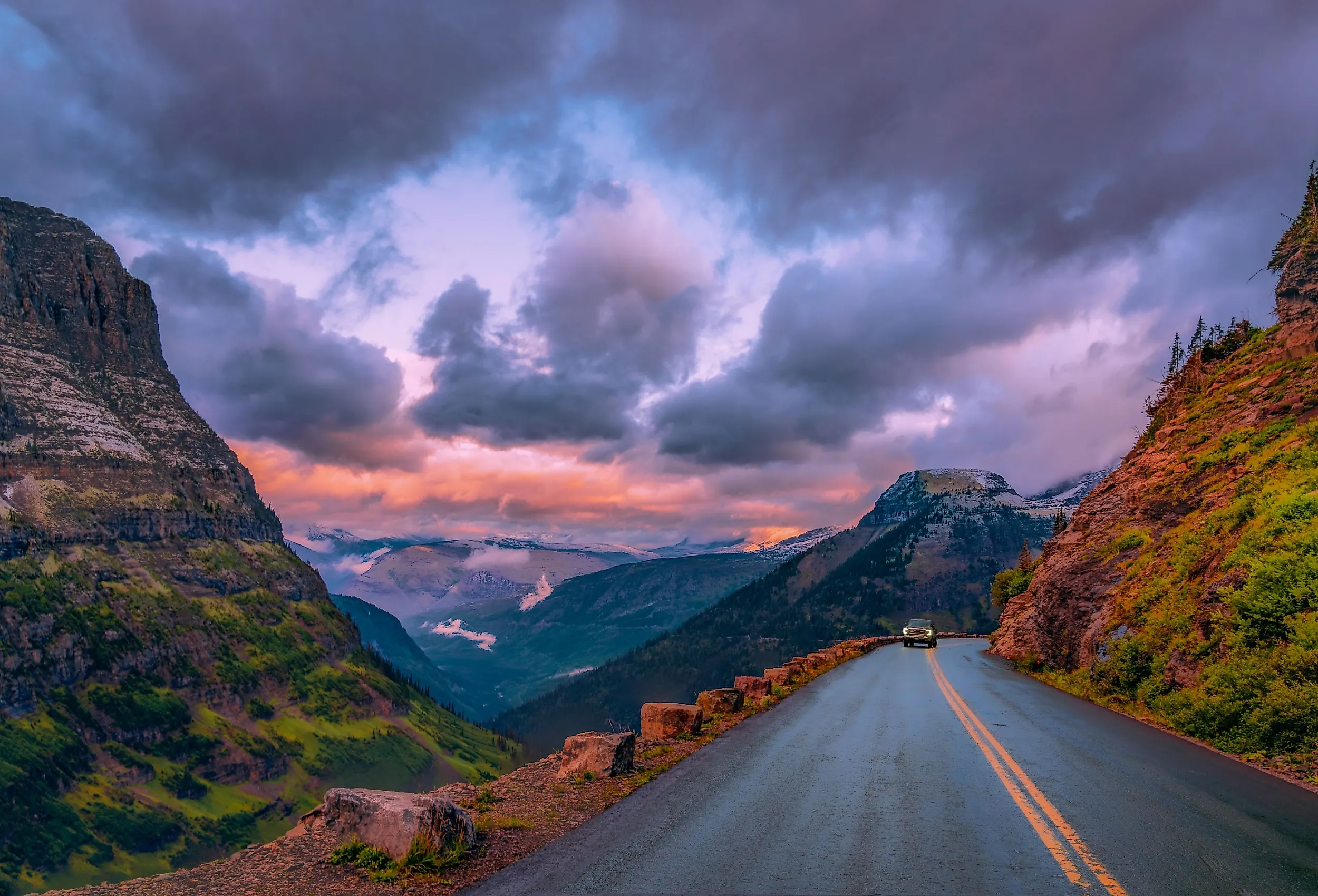
Going-To-The-Sun Road

Spanning Glacier National Park from east to west, Going-To-The-Sun Road is two lanes of high-altitude beauty crossing land shaped by glacial activity and rolling hill country. It opened in 1933, was added to the National Register of Historic Places in 1983, and was designated a National Historic Civil Engineering Landmark in 1985.
Along the way, there are chances to see mountainous peaks, bighorn sheep, waterfalls, and the occasional bear. The road crosses the Continental Divide at Logan Pass, which measures 6,646 feet. Logan Pass also holds the visitor center, a starting point for hikes and overlooks with wide-ranging views. The lower-elevation section of the road is open year-round but prone to closure during bad weather. The higher alpine sections generally open in early July and close in mid-October, depending on snow, so check conditions before heading out.
Big Sky Backcountry Byway

The Big Sky Backcountry Byway runs more than 60 miles through eastern Montana, passing through the state's desolate badlands, scoria buttes, and rolling prairieland. Terry anchors the route, and informational kiosks in town share regional happenings and local history.
Hunters and fishers should especially note that the Terry Badlands Wilderness Study Area offers solid land for game, with the nearby Yellowstone River open for fishing. Farther along, the area near the Missouri River offers similar outdoor activities, along with hiking and bird watching.
Looking Glass Hill Road

Only 10 miles long, Looking Glass Hill Road makes up for its length with wide vistas along the way. Overlapping Highway 49 in Montana, the route runs from Kiowa to East Glacier Park, passing valleys of aspen trees and free-ranging cattle grazing in the hills.
If you want to stretch your legs, pull into Two Medicine Lake, where hiking trails such as Twin Falls and the Upper Two Medicine Lake Trail await. You can also rent a boat or take a tour on Two Medicine Lake itself.
Lake Koocanusa Scenic Byway

Tucked in the northwestern corner of the state, Lake Koocanusa Byway runs 67 miles from Libby to Eureka. Established in 1992, the byway follows its namesake lake and the Kootenai River along State Highway 37. On the lake's west side, Forest Development Road 228 (closed in winter months) offers a more laid-back side loop. The cliffside road delivers views of both the lake and the river.
The byway also cuts through the Kootenai National Forest, where camping, hiking, rock climbing, and picnicking are all on the table. Lake Koocanusa has four paved boat ramps and is known as one of the better northwestern lakes for salmon fishing, while the river itself is a fishing playground with trophy-sized rainbow trout.
Skalkaho Pass Scenic Drive

For a drive on the wild side, head to Highway 38 at the west end of the state and hop on Skalkaho Pass Scenic Drive. The route winds 29 miles of twisty curves between Hamilton and Philipsburg, and trailers are not allowed because of the switchbacks. Bird watchers should look out for jays, juncos, flycatchers, sparrows, and woodpeckers. Larger species such as deer, black bears, mountain goats, badgers, moose, and coyotes are also plentiful, though no hunting is allowed.
Skalkaho Falls sits along the pass and makes a good picnic stop. Only 10 miles of the road is cleared by snow plows, so winter travel is challenging, but it makes a good excuse to bring out the snowmobile.
St. Regis-Paradise Scenic Byway

Nicknamed the "shortcut to Glacier National Park," the St. Regis-Paradise Byway takes its time across 30 miles of Highway 135 between the towns it is named for. The route's proximity to Lolo National Forest keeps Donlan Flats, tall canyons, lush mountains, and the Clark Fork River all within eyeline. Numerous trails up and down the route welcome hikers, horseback riders, and mountain bikers. If angling is more your speed, find a spot by the Clark Fork River and try for the northern pike, smallmouth bass, whitefish, or trout that swim its waters.
Chief Mountain Highway

Running between Waterton National Park and Glacier National Park, the Chief Mountain Highway covers 29 miles of valleys, peaks, prairies, and wetlands. From US-89, turn onto Highway 17 and follow it all the way to the Canadian border at the route's northern end.
Drivable in an afternoon, the highway has a rest stop at Belly River Campground along the way. Whether you stop to camp or not, Chief Mountain and Sentinel Mountain are two of the route's most striking sights, and the Blakiston and Waterton valleys make for memorable photos. Bring binoculars, because birds of prey, moose, deer, antelope, and bears often roam throughout the area.
Kings Hill Scenic Byway

Set amid Lewis and Clark National Forest, Kings Hill Scenic Byway offers 71 miles on Highway 89. Tall mountains, clear lakes, and gentle streams all come into view along the way, with the route running from the junction of Highway 89 and 12 up to Highway 87. Winter conditions can change quickly, so check before you go. Along the byway, Showdown Ski Area offers 34 runs with about 1,400 feet of vertical. If you would rather warm up than cool down, soak in a mineral spring at the town of White Sulphur Springs at the route's southern end.
Montana's Scenic Drives
Whether driving under stars or under full sun, these Montana routes reward anyone with a tank of gas and time to spare. Stop at a waterfall, soak in a hot spring, or just take in the landscape from behind the wheel. Each route has its own character, and wildlife sightings come with the package.