8 Most Scenic Drives in Colorado
Colorado Rocky Mountain highways are the stuff of legends. Singers, writers, and nature enthusiasts have tried for decades to put the beauty of these mountains into words. Many have come close, but the only way to fully experience these landscapes is to get behind the wheel and see them for yourself.
Colorado has some of the most dramatic scenery in the American West. We’ve compiled eight drives that take you straight into the heart of it. From winding alpine roads that crest the Continental Divide to quiet byways tracing ancient canyons, these routes highlight Colorado’s varied terrain. Each one can be completed in about 2 to 4 hours of driving, but plan for an afternoon. There are plenty of viewpoints, hikes, and pull-offs worth slowing down for.
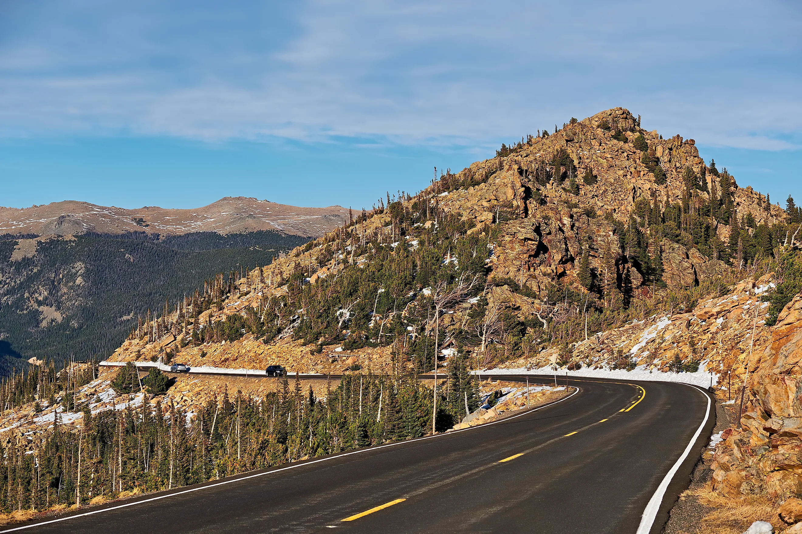
The Million-Dollar Highway

The Million Dollar Highway is a striking section of the San Juan Skyway, a 236-mile loop that twists and turns from Cortez to Ridgway, Colorado. The entire byway cuts deep into the San Juan Forest, but the road is at its best across the stretch known as the Million Dollar Highway between Ouray and Silverton.
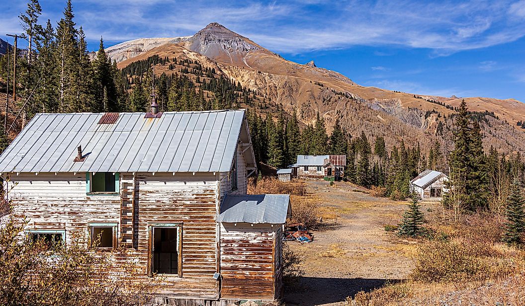
This 25-mile sector takes about 2 to 2.5 hours and passes several major landmarks in a short span. You’ll drive over Red Mountain Pass between Ouray and Silverton, where red rocks rise beside the road. Budget time for a stop at the Ironton Townsite, a ghost town converted to a mining-era monument just off the highway. With narrow lanes, steep drop-offs, and few guardrails, the Million Dollar Highway is as beautiful as it is hazardous. Drive slowly and enjoy the scenery as a series of tight switchbacks brings you close to the multihued San Juan Mountains.
Peak to Peak Scenic Byway

The Peak to Peak Scenic Byway is an out-and-back route that connects Estes Park to Black Hawk and Central City over 55 miles. The drive takes about 2 to 3 hours, a bit longer if you want extra time to enjoy the towns and places to stretch your legs along the way. The byway passes through Nederland, a small alpine town known as “the Ned.” It has good lunch spots, including fresh-cooked Nepalese food at Kathmandu and pizza and brews at Crosscut Pizza. The Ned is also home to the Carousel of Happiness, a useful stop before continuing your drive.
The road continues through sections of Golden Gate Canyon State Park and parts of the Arapaho and Roosevelt National Forests. It also connects you to Rocky Mountain National Park’s Wild Basin Entrance.
Trail Ridge Road

Located inside Rocky Mountain National Park, the 48-mile Trail Ridge Road climbs from Estes Park to Grand Lake in about two to three hours, crossing the park’s alpine core and the Continental Divide. This road is the highest continuous paved road in the United States, reaching an elevation of 12,183 feet and offering steady views of the Rocky Mountain wilderness.

Six miles from the Beaver Meadows entrance, the views begin at the Many Parks Curve Overlook, which introduces the surrounding peaks and valleys before you reach the higher sections. Near the road’s highest point, you’ll find the Alpine Visitor Center, the highest elevation visitor center in the National Park System. It is also the start of the Alpine Ridge Trail, a short and steep round-trip hike to a vista of the Never Summer Mountains. From there, the road descends, but the scenery continues. Drive slowly. Moose and elk often graze in the valleys below.
Mount Blue Sky Scenic Byway

The Mount Blue Sky Scenic Byway (formerly Mount Evans) starts in Idaho Springs, a historic mining town once defined by the search for gold. This 49-mile road leaves the former mining center and climbs over 7,000 feet in 28 miles, passing picnic areas and fishing spots in Echo Lake Park before reaching a peak altitude of 14,130 feet, the highest paved road in North America. The full drive takes about 2 hours without stops.
At these elevations, you may see mountain goats, bighorn sheep, marmots, and alpine wildflowers. Trees and brush thin out near the summit, where not even a bristlecone pine can survive. A small parking area sits beside the mountaintop and the defunct Meyer-Womble Observatory. From the lot, you can take a short hiking trail to the summit of Mount Blue Sky and reach a Colorado 14er. If you plan to continue to the Mount Blue Sky Recreation Area, you’ll need to purchase a ticket in advance.
Kebler Pass

Kebler Pass is a 30-mile road that runs between Crested Butte and Paonia. This byway is one of the rougher stretches on the list, with large portions of unpaved gravel. The route is still passable for most cars, and the 2-hour drive is worth it. It takes you through the largest aspen grove in Colorado. You’ll pass miles of aspen trees, many of which are genetically identical stems connected by shared root systems. This makes Kebler Pass especially striking in fall and spring, when the trees change color in unison.
Beyond the grove, Kebler Pass leads to Lost Lake and Horse Ranch Park, both of which offer hiking trails and good access to the aspen stands and surrounding alpine scenery. The pass reaches about 10,000 feet, with broad views of the Raggeds Wilderness.
Pikes Peak Highway

Since 1916, speed racers and motorcyclists have flocked to Colorado for the Pikes Peak International Hill Climb, an annual motorsport hill climb event. Featuring 156 turns along a 12.42-mile course, this byway has captivated professional drivers for over a century. The current world record is 07:57.148, but most visitors should plan 2 to 4 hours to enjoy the round-trip drive. You don’t need a Ferrari to make it up Pikes Peak. The road is scalable for all cars and climbs 6,000 feet through four ecological zones. You’ll cruise through forest, subalpine, alpine, and tundra backdrops on your way up.
A few miles into the road, you’ll see a Bigfoot warning sign, placed as a local curiosity. Once you reach the mountaintop, the Summit Visitor Center serves fresh hot donuts.
Top of the Rockies Scenic Byway

They don’t call it the Top of the Rockies byway for nothing. The full byway covers more than 115 miles and takes about 4 to 5 hours, but many travelers drive the shorter 80-mile segment, which can be done in roughly 3 hours while staying at or above 9,000 feet. This stretch crosses the Continental Divide and traces the Arkansas River toward its source near Fremont Pass.

Along the way, you’ll pass several small mountain towns. The byway has entrances near Vail, Frisco, and Granite, and it connects to State Highway 82, Independence Pass, and Aspen. It also brings you into Leadville, the highest incorporated city in the United States. On the way, stop at the Camp Hale National Monument, an alpine area once used as a winter training ground for World War II soldiers. The 53,804-acre site has hiking trails, markers, and campgrounds for those who want to extend their trip.
Unaweep Tabeguache Scenic Byway

Most of Colorado’s scenic drives take you through high alpine environments, but the Unaweep Tabeguache covers different terrain. Stretching from Whitewater down to Placerville, this route runs through 133 miles of red canyon country, and takes about 3 hours of driving. The road winds along river and forest ecosystems, red rock plateaus, and broad areas of public land.
Stop at Unaweep Canyon, where paleontologists have found partial skeletons of Diplodocus and Camarasaurus. The drive also brings you to Native American structures, petroglyphs, and other artifacts. The public lands along the byway offer mountain biking, hiking, watersports, and more. Consider spending the night near Norwood, a byway-side town designated as a Dark Sky Community.
In Colorado, it pays to take the scenic route
Next time you find yourself in the state, take the extra time to drive one of these byways and see what those colors are all about. From alpine tundra to sandstone canyons, these road trips show the range of Colorado’s natural beauty. On these routes, the journey matters as much as the destination.