7 Great Road Trips to Take in Rhode Island
Rhode Island works unusually well for road trips for several reasons. Distances are short, roads change character quickly, and scenery shifts without long stretches of monotony. In a single afternoon, you can move from dense mill towns along river corridors to open farmland, from sheltered coastal lanes to exposed ocean-facing roads along the state’s southern shore. Most drives here are manageable at a relaxed pace, with frequent pull-offs, clear sightlines, and enough variation to stay engaging without demanding constant attention. Traffic can slow things near towns and beaches, but the state’s scale makes detours easy and drive times predictable. These routes are worth driving not because of what they connect, but because of how they feel from the driver’s seat: curves that follow the land, roads that run close to coastal mansions, and scenery that changes mile by mile.
The Newport Loop (Ocean Drive)

Ocean Drive is a compact, low-speed coastal loop where the road stays close to the shoreline for much of its length. The pavement is smooth and clearly marked, with gentle curves rather than sharp turns, and a steady rhythm shaped by the coast. The speed limit sits around 25 mph, and traffic typically moves slowly, especially in summer when cyclists and runners share the shoulder. This is a drive where you settle into second or third gear and let the road dictate the pace.
The ocean remains in view for long stretches, occasionally dropping away to open grass or rocky edges before returning again. Begin at the intersection of Ocean Avenue and Coggeshall Avenue near the Newport mansions. A short drive will bring you to Gooseberry Beach, which is sheltered by boulders and grassy dunes, then to Green Bridge for views across the water. There’s King's Beach Fishing Area, which is commonly used for kayaking in calm conditions, and Brenton Point State Park, which offers open views of Narragansett Bay at its juncture with the Atlantic. The full loop is roughly 10 miles and takes about 30 minutes without stops, longer if traffic is heavy. It works best early in the morning or outside peak summer weekends.
Blackstone River Valley National Heritage Corridor (Rhode Island Section)

The Rhode Island section of the Blackstone River Valley National Heritage Corridor snakes through a region reputed to be the “Birthplace of the American Industrial Revolution.” This drive is not linear, although it is most often driven by following Route 146 and nearby local roads that parallel the river. The drive typically begins in Pawtucket near the Blackstone Valley Visitor Center, where urban streets feed into the corridor. Moving north, the road alternates between tight town segments and short open stretches near the river. After passing Central Falls and Valley Falls, the drive opens briefly near Blackstone River State Park, where the road briefly feels removed from the surrounding towns. The Rhode Island portion concludes around Woonsocket, where streets narrow again, and traffic density increases. Expect mostly straight alignment, modest elevation change, and steady traffic flow. The Rhode Island stretch spans about 12 miles and usually takes 20-30 minutes, with park entrances and visitor areas providing clear stopping points.
Route 102: North Smithfield to Wickford

Route 102 is a long inland drive that unfolds gradually from north to south. Beginning in North Smithfield, the road starts in a semi-developed setting before quickly transitioning into quieter stretches. As Route 102 enters Burrillville, roadside development briefly increases, including small businesses like Village Barn Country Store, before the road returns to wooded stretches. Continuing south, the route moves through Glocester and into Scituate, with increasing tree cover and longer gaps between intersections. This central section feels the most remote, especially where forests narrow the sightlines, and the road gently bends. Beyond this point, the road trends west toward Foster as the landscape becomes more wooded and rural. Farther south, Route 102 passes through Coventry and West Greenwich before turning east to Exeter, where the pace remains steady. Near Exeter, the road passes close to Fisherville Brook Wildlife Refuge, where pull-offs allow access to short trails and small waterfalls. The drive ends in Wickford, where traffic slows as the village comes into view. The full 44-mile drive typically takes 75-90 minutes end to end.
Route 114: Eastern Rhode Island to Newport

Route 114 provides a steady southbound drive along the eastern side of Narragansett Bay. Starting near Providence via I-195, drivers merge onto Route 114 and quickly leave highway speeds behind. The road moves through Barrington first, with consistent traffic lights and suburban pacing. From Barrington, the drive heads southeast through Warren and features gentle curves and a peaceful waterfront. After entering Bristol, the road passes the Audubon Society of Rhode Island Nature Center and Aquarium, bringing brief glimpses of the bay, especially near Colt State Park, where the road straightens and offers open views across the water. Beyond Bristol, the route becomes intermittently quieter before reconnecting with heavier traffic as it approaches Newport. The drive is mostly flat with clear lane markings. The full 34-mile route usually takes about an hour, with several well-marked park entrances and roadside parking areas for breaks.
Shannock Road

Shannock Road is a short connector road best experienced from Route 112 toward Route 2. The drive begins with narrow lanes and immediate tree cover, creating a shaded, enclosed feel. Start at the intersection of Route 112 and Old Shannock Road near Patricia Sprague Forest Preserve. From here, the road curves gently as it descends toward the Pawcatuck River. Midway through, mill-era structures line the road as it passes through the Shannock Historic District. Soon after, the river comes into view near Horseshoe Falls, where a small pull-off allows for a brief stop. The road then proceeds in a southern direction before meeting Route 2 near ReStore RI, a non-profit business and donation center that sells new and gently used furniture and other home accessories to the public at discounted prices. The drive lasts only a few minutes, but its tight alignment, low speeds, and changing textures make it feel distinct.
Route 1A: Wickford to Narragansett

The drive starts quietly as village streets in Wickford feed into Boston Neck Road, passing residential lots and small fields. Southbound, the route skirts the John H. Chafee Nature Preserve at Rome Point, where vegetation thins and coastal air becomes more noticeable. A short detour leads to Rome Point Seal Beach, but the main road continues with gentle curves and changing sightlines. Farther along, the Jamestown Bridge and Casey Farm mark the transition into more open coastal scenery. Approaching Narragansett, traffic increases and the road straightens slightly before reaching the town beach area. The drive takes about 30-40 minutes and is smoothest outside peak summer beach hours. At the tail end, Narragansett Town Beach offers soft sand and good waves in a classic New England setting.
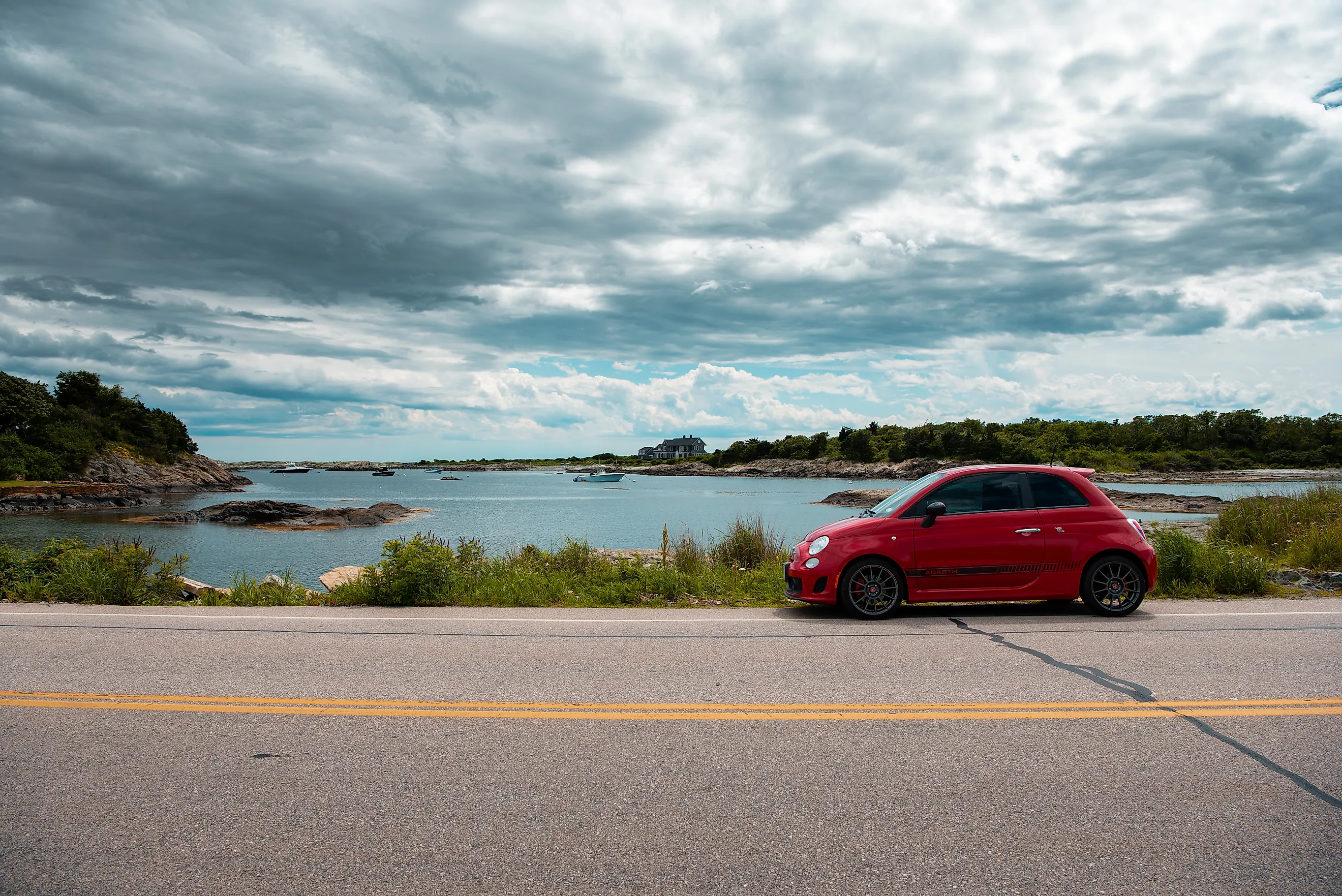
Route 77: Tiverton to Sakonnet Point

Route 77 runs between Tiverton and Sakonnet Point, following a relaxed coastal-rural alignment. The drive begins at Tiverton and passes several outdoor attractions, including Pocasset Ridge Conservation Area and the Audubon Emilie Ruecker Wildlife Refuge, where long sightlines and minimal intersections define the experience. After Tiverton Four Corners, the road gradually opens into fields and low stone walls, with intermittent views of the Sakonnet River as it approaches the coast, with intermittent views of the Sakonnet River as it approaches the coast. The final stretch approaches Sakonnet Point and Lloyd’s Beach, where the drive slows down slightly, and water views become more prominent. Wind exposure increases near the coast. The full drive takes about 35-45 minutes and maintains a steady, unhurried pace throughout.
A State Built for Short, Varied Drives
Rhode Island works well for road trips because coastal roads, inland connectors, and town streets change character quickly over short distances. Roads are long enough to establish a rhythm but short enough to avoid fatigue. Coastal exposure, forested corridors, and small towns appear in quick succession, keeping drives visually and mechanically interesting. Seasonal shifts noticeably change how the same roads feel, offering repeat value rather than one-off novelty. Whether you have an hour or a full day, these routes work best when approached at an unhurried pace, allowing drivers to notice how lanes narrow, curves follow the land, and scenery shifts over short distances.