6 Best Natural Wonders To Visit In Montana This Year
Montana’s natural wonders run from alpine peaks to prairie badlands, with room to take your time getting between them. Glacier National Park alone covers a million acres of alpine peaks and turquoise lakes along the Canadian border. Flathead Lake is the largest natural freshwater lake west of the Mississippi, more than 300 feet deep in places. Makoshika State Park protects 11,538 acres of eastern badlands where T. rex and Triceratops bones still turn up. Pompeys Pillar still has William Clark’s 1806 signature carved in sandstone, the only physical trace left of the Lewis and Clark Expedition. Custer Gallatin National Forest stretches three million acres of mountains and river valleys right up against Yellowstone.
Glacier National Park

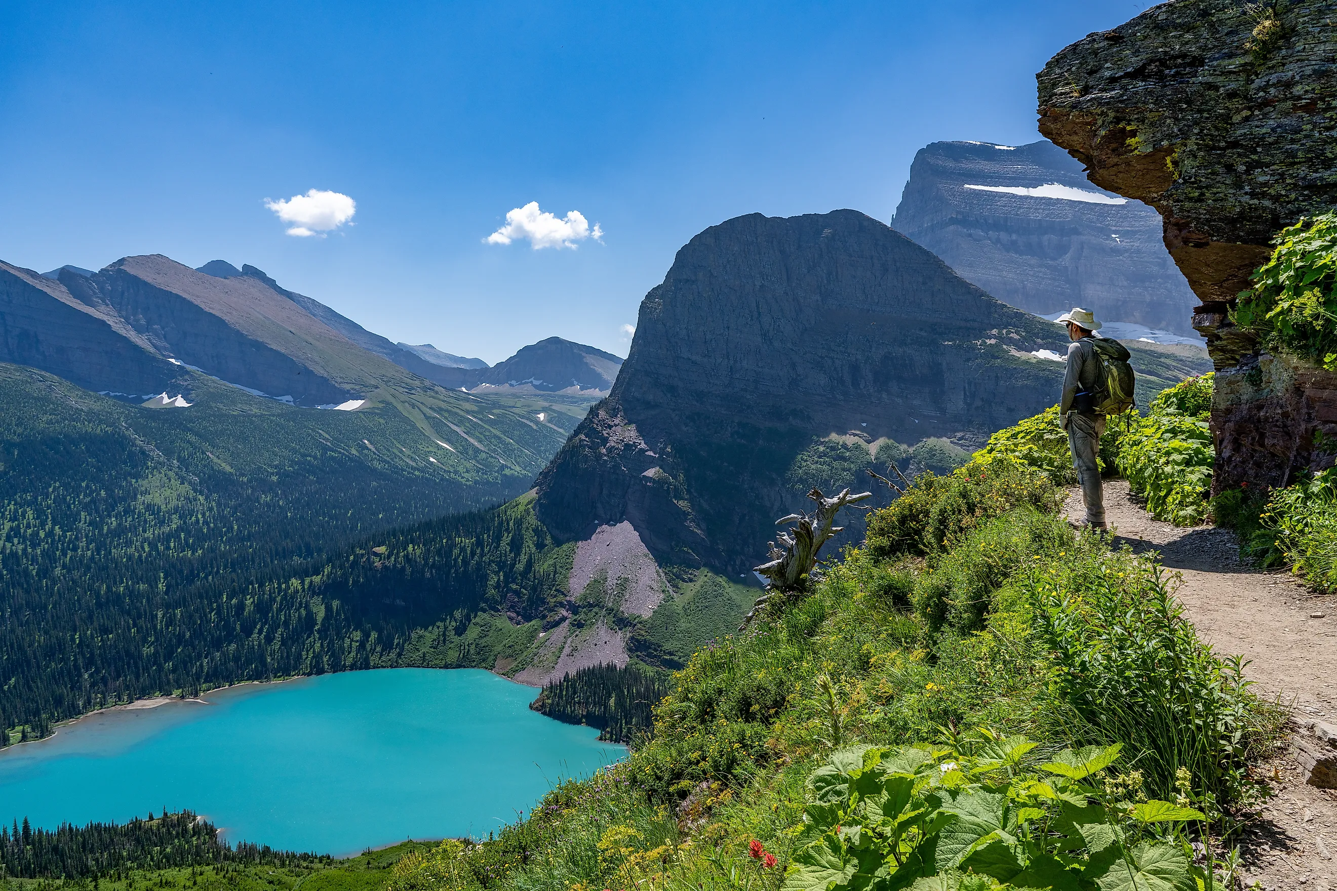
Glacier National Park holds Montana’s most impressive collection of natural landmarks, spanning more than one million acres of alpine peaks, glacial valleys, and clear lakes along the Canadian border. Known as the “Crown of the Continent,” it contains over 700 miles of hiking trails leading to some of the most striking mountain scenery in the United States, let alone the Rockies.
For the easiest, and perhaps best, way to tour the area, the Going-to-the-Sun Road cuts through the heart of the park, climbing along cliffsides and crossing locales like Logan Pass, where sweeping views of snowcapped summits and glacier-carved terrain open up in all directions. Beyond the drive, the park’s turquoise lakes such as Lake McDonald and St. Mary Lake are worth a stop, and mountain goats and bighorn sheep show up at various points. Many travelers also spend the night at the historic Many Glacier Hotel.

Although the park’s glaciers are shrinking year over year, the scenery holds up regardless of when you visit. Note that much of the park, including the Going-to-the-Sun Road, closes during winter due to snow.
Flathead Lake

Flathead Lake is the largest natural freshwater lake west of the Mississippi River, stretching across a broad valley framed by the Mission and Salish Mountains in northwestern Montana. Like many outdoor attractions in the state, this one was formed by glacial activity, and the lake is best known for its clear water and depth, reaching more than 300 feet in places.
Its 185-mile shoreline includes a mix of public access points, small communities, protected green spaces, and orchard-lined slopes, particularly around Polson and Bigfork. Wild Horse Island is the largest island on the lake and supports a small population of wild horses, plus bighorn sheep and mule deer. The island is managed by Wild Horse Island State Park, is for day-use only, and is generally only reachable via privately owned boats.

A central feature of Montana’s northwestern corner, the lake is one of the state’s few recreational water bodies of this size and an excellent place to stop if you are headed from the east into the mountains.
Makoshika State Park

Makoshika State Park protects the largest expanse of badlands in Montana, making it the biggest state park in Montana at 11,538 acres. Located on the outskirts of Glendive, the landscape is a showcase of wind and water working over eons, exposing layered rock that preserves a rich fossil record from the late Cretaceous period.
Deeply eroded clay formations, sharp ridgelines, and isolated buttes carved over millions of years are everywhere here, but the park is best known for dinosaur remains belonging to Tyrannosaurus rex and Triceratops. A network of interpretive trails highlights both the geology and the paleontological importance Makoshika has become known for.
The terrain in and around the park is dry and exposed, with sparse vegetation and wide-open, desert-like vistas that contrast heavily with Montana’s Rocky Mountains to the west. The park is also generally far less crowded than the likes of Glacier National Park and other alpine parklands, making for a quieter visit much of the time.
Pompeys Pillar National Monument

A historic landmark as well as a natural one, Pompeys Pillar National Monument is a nearly 200-foot sandstone butte standing in the otherwise open grasslands northeast of Billings. This roadside stop off I-94 is composed of soft rock layers eroded into a steep, isolated formation, with wide views over the surrounding area from its summit and a wooden staircase that allows direct access to the top.
What sets this site apart is the preserved signature of William Clark, carved into the rock during the Lewis and Clark Expedition in 1806, the only remaining physical evidence of their journey. The rock was also named by Clark, likely after Sacagawea’s son, whom he nicknamed “Pomp.” The surface also contains numerous petroglyphs attributed to Indigenous peoples, most of which are open to view.
Medicine Rocks State Park

Medicine Rocks State Park features a dense concentration of sandstone formations shaped into narrow spires, arches, and perforated walls. The rock here is remarkably soft and heavily eroded, creating openings large enough to walk through and surfaces marked by patterns of pits and grooves of varying sizes.
A short drive north of Ekalaka, the formations jut directly from a sea of farmland and grassy prairies. Like Pompeys Pillar, many of the rocks display historic inscriptions, including names carved by early settlers from the late 1800s and petroglyphs created by native inhabitants from much earlier.
The name comes from Indigenous use of the area for ceremonial purposes, reflecting its long-standing cultural significance alongside its distinct geological appeal.
Custer Gallatin National Forest

The Custer Gallatin National Forest covers more than 3 million acres of southern Montana, forming a connected system of mountain ranges, river valleys, and high plateaus adjacent to Yellowstone National Park. It stretches from the Absaroka-Beartooth range near the Wyoming border to the Madison and Gallatin ranges west of Bozeman.
Elevation often changes sharply across this forest, from sagebrush foothills to alpine topography above 10,000 feet. The forest is also navigable, with the Beartooth Highway cutting through its eastern section, crossing high tundra-like terrain dotted with small lakes and exposed granite patches. Watch for wildlife including grizzly bears, elk, moose, and mountain goats, each concentrated in different elevation bands depending on season.
Local river systems including the Gallatin and Yellowstone also carve through the forest and are commonly used for fishing and rafting.
Note that snowpack persists well into summer in many spots across Custer Gallatin. From July through September, a web of lower-elevation trails takes you through wildflower meadows, dense woodlands, backcountry campsites, and viewpoints worth the trip.
Explore Some Of Montana’s Greatest Natural Features In 2026
From arid badlands and prairiescapes to alpine ranges and sizable inland lakes, each destination above shows off a side of Montana worth exploring this year. Whether you’re after erosion-carved sandstone, glacial valleys, or lively forests, together they form a set of must-see stops for any road trip inside this northern state.