11 Best Road Trips To Take In Washington
Washington State's scenic byways pack more variety into a single day of driving than most states manage in a week. The Cascade Loop runs 440 miles past alpine lakes and Bavarian-themed Leavenworth. The Olympic Peninsula Loop circles a national park that swings from temperate rainforest to coastal sea stacks. The North Cascades Highway cuts straight through the heart of the so-called American Alps, with Diablo Lake's turquoise water as the standout view. The eleven routes below cover the rest, from saltwater islands to wheat-field horizons.
Cascade Loop Scenic Byway

The Cascade Loop Scenic Byway spans 440 miles and showcases some of Washington’s most diverse landscapes. This route, which passes by towns like Leavenworth and Winthrop, offers views of the North Cascades, farmlands, and river valleys. Established to promote tourism and preserve the natural beauty of the region, the byway follows historic trade routes and paths used by Native American tribes, pioneers, and fur trappers.
Visitors can explore the Alpine Lakes Wilderness near Stevens Pass, where numerous trails lead to mountain lakes and forests. In Leavenworth, guests can visit the Leavenworth National Fish Hatchery, which focuses on salmon conservation and has educational tours. The North Cascades National Park Complex has numerous hiking opportunities and vistas of peaks and meadows, accessible from various points along the loop.
Olympic Peninsula Loop

The Olympic Peninsula Loop is a 329-mile journey around the Olympic Peninsula, providing access to diverse ecosystems, including temperate rainforests, coastlines, and alpine environments. This route circles the Olympic National Park, which was established in 1938 to protect its landscapes and wildlife. The peninsula's history is rich in Native American culture, with several tribes, such as the Quinault and Makah, still residing in the area.
Visitors can explore the Hoh Rain Forest, one of the few remaining temperate rainforests worldwide, through the Hall of Mosses Trail and the Spruce Nature Trail, enjoying its lush greenery and moss-covered trees. Hurricane Ridge offers panoramic views of the Olympic Mountains and features various hiking trails across subalpine terrain, where visitors might see wildlife such as black-tailed deer and marmots. Rialto Beach, part of the park's coastal area, provides opportunities to see tide pools, sea stacks, and the dynamic waves of the Pacific Ocean, perfect for beachcombing and photography.
Mount Baker Highway

Mount Baker Highway, also known as State Route 542, stretches for 58 miles from Bellingham to Artist Point near the summit of Mount Baker. This highway, completed in 1931, provides access to the Mount Baker-Snoqualmie National Forest and offers spectacular views of Mount Baker, one of the most glaciated volcanic peaks in the contiguous United States. The route ascends through dense forests, past alpine meadows, and along river valleys, culminating in high-altitude vistas of snow-covered mountains and rugged terrain.
Visitors can visit Nooksack Falls, a 100-foot waterfall on the North Fork of the Nooksack River, accessible via a short trail from the highway. The Heather Meadows Visitor Center, situated near the end of the highway, features interpretive displays and is a starting point for many alpine hikes. Artist Point, at the highway's end, offers wide views of Mount Baker and Mount Shuksan and acts as a gateway to high-elevation hiking trails.
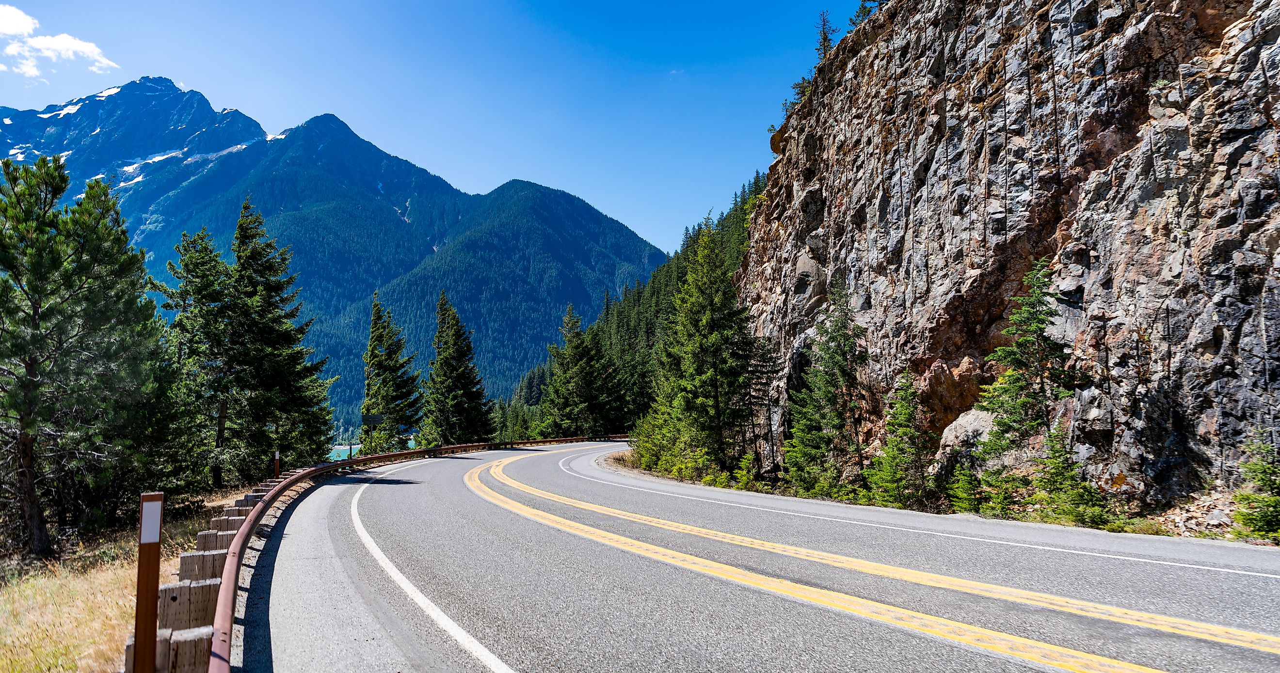
North Cascades Highway

North Cascades Highway, part of State Route 20, spans 120 miles from the Skagit Valley to the Methow Valley. This route, completed in 1972, cuts through the Ross Lake National Recreation Area at the heart of the North Cascades National Park complex, showcasing some of the most rugged and remote landscapes in Washington. The highway traverses forests, through steep mountainsides, and along glacial rivers.
Visitors can hike to Diablo Lake Overlook, which has views of the turquoise waters of Diablo Lake, created by a hydroelectric dam on the Skagit River. Washington Pass Overlook has a panoramic vista of Liberty Bell Mountain and the surrounding peaks, with a short, accessible trail leading to the viewpoint. Ross Lake National Recreation Area, adjacent to the highway, has opportunities for boating, fishing, and exploring the lake and surrounding wilderness.
San Juan Islands Scenic Byway

The San Juan Islands Scenic Byway features a network of roads and ferry routes linking the islands in the Salish Sea. It covers the main islands of San Juan, Orcas, and Lopez, each with unique landscapes and historical landmarks. These islands, steeped in maritime history, have been influenced by indigenous peoples, European explorers, and American settlers.
Visitors can explore Lime Kiln Point State Park on San Juan Island, known for its whale-watching opportunities from the shore. Moran State Park on Orcas Island has hiking trails to Mount Constitution, the highest point in the San Juan Islands, with views extending to Canada. On Lopez Island, guests can visit Spencer Spit State Park, which has tidal lagoons, sandy beaches, and camping facilities.
Chuckanut Drive

Chuckanut Drive, also known as State Route 11, stretches 21 miles between Bellingham and Bow, hugging the edge of the Chuckanut Mountains and offering views of Samish Bay. Opened to automobile traffic in 1916 and now one of Washington's most beloved scenic byways, it provides access to a coastal environment that includes rocky shorelines, forests, and vistas. The route winds through a region historically used by Native American tribes for fishing and hunting.
Guests can visit Larrabee State Park, the first state park in Washington, which has trails through coastal forests, access to tide pools, and views of the San Juan Islands. Samish Overlook provides a viewpoint for hang gliding and paragliding, as well as hiking trails that connect to the Pacific Northwest Trail. Oyster Dome, a popular hiking destination, is a challenging ascent with views of Samish Bay and the surrounding islands.
Mount Rainier Loop

The Mount Rainier Loop encompasses a network of roads encircling Mount Rainier, the highest peak in the Cascade Range at 14,411 feet. This loop provides access to Mount Rainier National Park, established in 1899, to protect its diverse ecosystems and landscapes. The route includes dense old-growth forests, subalpine meadows, and active glaciers.
Visitors can explore Paradise on the south slope of Mount Rainier, famous for its wildflower meadows and the Paradise Jackson Visitor Center. Sunrise, the highest point reachable by car, offers views of Mount Rainier and features extensive hiking trails through subalpine terrain. The Grove of the Patriarchs Trail guides visitors through an old-growth forest with tall Douglas firs and Western red cedars, accessible via a suspension bridge over the Ohanapecosh River.
Palouse Scenic Byway

The Palouse Scenic Byway meanders through the gentle hills and rich farmland of southeastern Washington, recognized for its distinctive loess hills created by wind-blown silt. This region of significant agriculture produces crops such as wheat, barley, lentils, and more. Traveling along the byway, travelers encounter small towns and enjoy views of the area's unique landscape and farming tradition.
Guests can see Steptoe Butte State Park, where a narrow road leads to the summit, offering views of the Palouse hills and patchwork fields. Palouse Falls State Park features a dramatic 198-foot waterfall, the last remaining year-round waterfall along the path of the Ice Age floods. Kamiak Butte County Park has hiking trails through forests and meadows, with a summit providing views of the Palouse landscape.
Stevens Pass Greenway

The Stevens Pass Greenway runs along U.S. Route 2 through the Skykomish Valley and crosses Stevens Pass in the Cascade Range. Historically, this route was used by Native American tribes, later by railroad workers and loggers, providing access to rivers, forests, and mountain environments. Named after John Stevens, the surveyor who mapped it for the Great Northern Railway in the late 1800s, the greenway highlights the region's engineering achievements.
Visitors can check out Wallace Falls State Park, home to a series of nine waterfalls along the Wallace River, with hiking trails through lush forests. Deception Falls, a short stop along the highway, has a scenic loop trail with views of cascading waterfalls and interpretive signs about the area's natural history. Lake Wenatchee State Park, located near the eastern end of the greenway, has opportunities for swimming, boating, and hiking.
Whidbey Scenic Isle Way

The Whidbey Scenic Isle Way traverses the length of Whidbey Island, the largest island in Washington State. Known for its diverse landscapes, including rolling farmlands, coastal bluffs, and dense forests, the island's history includes Native American heritage, European exploration, and early American military presence.
Guests can visit Deception Pass State Park, which spans the northern tip of Whidbey Island and features cliffs, tidal currents, and bridges connecting to Fidalgo Island. Ebey's Landing National Historical Reserve preserves the island's agricultural landscape and historic structures, with trails that have views of Puget Sound and the Olympic Mountains. South Whidbey State Park, located on the island's southwestern shore, has old-growth forests, hiking trails, and beach access.
Yakima River Canyon Scenic Byway

The Yakima River Canyon Scenic Byway, also known as State Route 821, follows the Yakima River through a dramatic canyon landscape between Ellensburg and Selah. This route provides access to a unique ecosystem of basalt cliffs, hills, and a meandering river that supports diverse wildlife, including eagles, deer, and bighorn sheep. The byway has been a vital travel corridor for thousands of years.
Visitors can stop at Umtanum Creek Recreation Area, where a suspension bridge over the Yakima River leads to hiking trails through the canyon and opportunities for wildlife viewing. Red's Fly Shop, located along the byway, offers guided fly-fishing trips and equipment rentals, catering to anglers seeking trout in the Yakima River. Roza Recreation Site has river access for boating and fishing, as well as picnic areas with views of the canyon's rugged terrain.
In Summary
Washington's scenic byways offer more than just beautiful drives; they provide immersive experiences into the state's diverse ecosystems and rich history. Each road trip reveals a different facet of Washington's natural and cultural landscape, from the dramatic vistas of the North Cascades Highway to the lush rainforests along the Olympic Peninsula Loop. Whether you're exploring ancient forests, volcanic peaks, or coastal bluffs, these routes offer countless opportunities for adventure and discovery.