Pocono Mountains
Commonly known as the Poconos, the Pocono Mountains is a highland region spread across the Wayne, Monroe, Pike, and Carbon Counties in the northeastern portion of the US State of Pennsylvania. The name ‘Pocono’ has been derived from the native Musnee term ‘Pokawachne,’ which means “Creek Between Two Hills.” The Pocono Mountains are bounded by the Lehigh Valley in the south; Coal Region and Wyoming Valley in the west; the Delaware River and Delaware Water Gap in the east; and Lake Wallenpaupack in the north. A famous outdoor recreational destination for residents and tourists alike, the Poconos offers several recreational activities such as camping, racing, skiing, horseback riding, mountain hiking, casino gaming, and whitewater rafting.
Geography Of Pocono Mountains

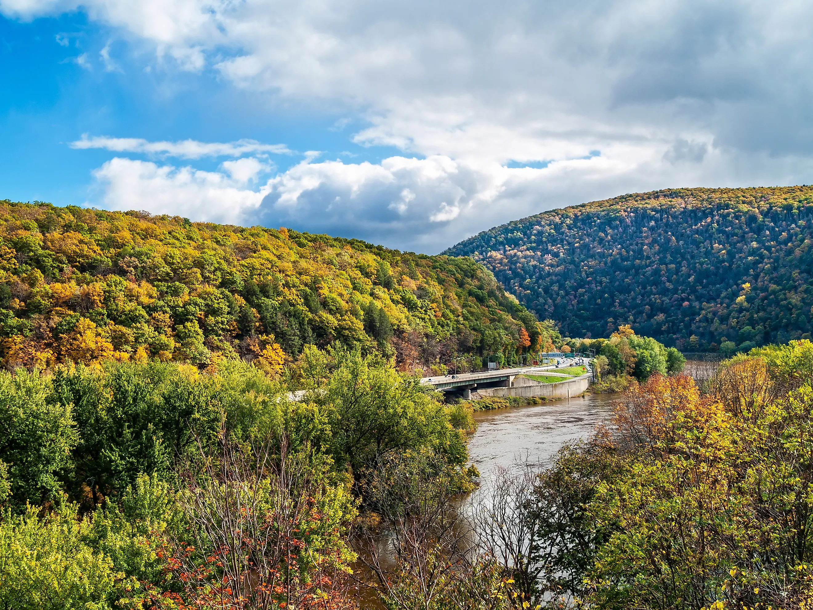
Encompassing more than 2,500 square miles, Pocono Mountains geologically form a part of the greater Allegheny Plateau. A significant portion of this wooded hill and valley region is placed within the broader “New York-Newark, NY-NJ-CT-PA Combined Statistical Area.” Located in Monroe County, Kistler Ledge, with an elevation of more than 2,215 ft, is the highest summit of the Poconos. The lowest part of the Poconos is located in Pike County, which reaches an elevation of only 350 ft. The 282-mile-long Delaware River, flowing through the mountains, gives the region its indigenous name, ‘Pokawachne,’ which means “stream between two mountains.” The 109-mile-long Lehigh River and 31.3-mile-long Lackawaxen River also flow through the mountainous region.
Northeastern Pennsylvania’s Pocono Mountains region is further divided into six regions: the Mountain Region, the Delaware River Region, Wyoming Valley, the Lehigh River Gorge Region, the Lake Region, and the Upper Delaware River Region. The Mountain Region includes the counties of Monroe, Luzerne, the northern part of Carbon, and the southern part of Lackawanna counties. The Lake Region and the Upper Delaware River Region include the Pike and Wayne Counties. The Delaware River Region includes Monroe and Pike Counties, while the Wyoming Valley includes Luzerne County.

Many state highways, like Pennsylvania Route 903, Pennsylvania Route 611, Pennsylvania Route 115, Pennsylvania Route 33, Pennsylvania Route 715, and Pennsylvania Route 940, serve the Pocono Mountains region. The 134 miles long north-south Pennsylvania Route 309 passes through the region’s western end and links Northeastern Pennsylvania with the Delaware Valley region. The 211.74-mile-long U.S. Route 209 and the transcontinental highway U.S. Route 6 also serve the Pocono Mountains region. Designated a ‘scenic route’ in the state, the U.S. Route 6 highway begins near the Californian city of Bishop and runs for more than 40.505 miles to the route’s eastern terminus at the New England town of Provincetown. Interstate 80 is the major east-west interstate highway that serves the Poconos Mountain Region. The 28.45-mile-long Interstate 380, which branches off from Interstate 80, links Poconos to the city of Scranton.
Climate Of Pocono Mountains

The Glaciated Low Plateau region in the northern and eastern parts of the Poconos experiences a temperate continental climate as per the Trewartha Climate Classification. The region has warm summers, cool winters, and ample yearly precipitation. July is the year’s warmest month and the peak month for thunderstorm activities. January is the year’s coldest as well as the snowiest month. From December to March every year during the nor’easters’ time, ice storms and significant snowstorms occur, depositing more than 12 inches of snow. Both the Glaciated Pocono Mountain Region in the central and western parts of the Poconos and the Ridge and Valley Region in the southern part of the Poconos experience the same temperate continental climate.
Brief History Of Pocono Mountains
Several Native American tribes, like Iroquois, Minisink, Paupack, Lenape, and Shawnee, initially inhabited the Poconos Mountain area. Archaeological excavations close to Stroudsburg revealed one of the Northeastern United States’ oldest Native American sites, with habitation dating back to more than 10,000 years. The Dutch established settlements close to the Delaware Water Gap in 1659 but were forced by the English to abandon the site in 1664. The English and German settlers started arriving by 1742 in the Pocono Mountains region, and the first permanent settlement was founded at Shawnee by Nicholas Depui in 1725.

In 1829, the first boarding house hotel was established at the Delaware Water Gap. In due course, hordes of visitors from the burgeoning cities of New York and Philadelphia started arriving here in the mountains to escape from the summer heat. The coal industry also simultaneously prospered beside the resort industry. In 1926, the Pennsylvania Power and Light Company started constructing Lake Wallenpaupack, one of the state’s largest artificial reservoirs having 52 miles of unbroken shoreline. This big lake currently serves as a popular water sport and recreation destination. With the development of full-service resorts, the Poconos Mountains area soon became a popular vacation destination.
Ecology Of Pocono Mountains

The Glaciated Low Plateau region in the northern and eastern parts of the Poconos is dominated by Northern Hardwood Forests, especially in Lake Wallenpaupack’s north and west portions. The Appalachian Oak of the Eastern Hardwood Forest dominates Lake Wallenpaupack's southern and eastern parts. Peak fall colors appear in the forest during early October, while the spring bloom takes place in early May. Northern Hardwood Forests also dominate the Glaciated Pocono Plateau region in the central and western parts of the Poconos. The Ridge and Valley region in the southern Poconos is covered by Appalachian Oak of Eastern Hardwood Forest. Here, the peak fall colors appear in mid-October, while the peak spring bloom occurs during late April.
Attractions In The Pocono Mountains
Bushkill Falls

Nicknamed “The Niagara Falls of Pennsylvania,” Bushkill Falls is a collection of eight privately owned waterfalls located in the Pocono Mountains in Pennsylvania’s Lehman Township. The waters of the Pond Run Creek and Big Bushkill Creek descend the Pocono Mountains and flow toward the Delaware River, forming this series of eight waterfalls. One of the most popular natural landmarks of the Poconos, the area contains several trails and bridges, and is a perfect spot for hiking and birdwatching. The main Bushkill Falls and the canyon area can be reached through boardwalk and stairs.
Pocono Raceway

Also referred to as “The Tricky Triangle,” the Pocono Raceway is a significant automobile race track situated in the Pocono Mountains in the unincorporated community of Long Pond. The raceway hosts three NASCAR national series races and an ARCA Menards Series event during July. Formerly the Pocono Raceway hosted several races, including the Pocono Organics CBD 325, the ABC Supply 500, and an IndyCar race. The two NASCAR weekends held at this raceway are vital for boosting the local economy. The Pocono Raceway is also the nearest major professional race track that is located close to Philadelphia and the principal areas of New York and New Jersey.
Big Pocono State Park

This 1,305.6-acre state park is situated in Northeastern Pennsylvania’s Jackson and Pocono townships. Due to the park’s placement on Camelback Mountain, one can get to witness expansive portions of Eastern Pennsylvania, and parts of New York and New Jersey. The Delaware Water Gap can also be seen from here, and a 1.4-mile-long paved drive around the summit offers visitors scenic views in all directions. The park features a hiking trail system that contains 7 miles of interconnecting trails of varying terrain and grade. In addition, there is also a 3-mile-long horseback riding trail, three picnic areas with a total of 50 tables, and skiing and snowboarding areas at the Camelback Mountain Resort. Except for the resort, the park closes during the winter season and reopens when the conditions are suitable during spring.
The Poconos is indeed a famous outdoor recreation destination for residents and visitors. Many tourists come to this amazing region of mountains, clear streams, and dense forests to enjoy the scenery and escape from the mundaneness of the neighboring metropolises. Boasting several trails, waterfalls, lakes, resorts, and recreational facilities, the Poconos Mountains are a perfect place to spend some memorable moments with your loved ones.


