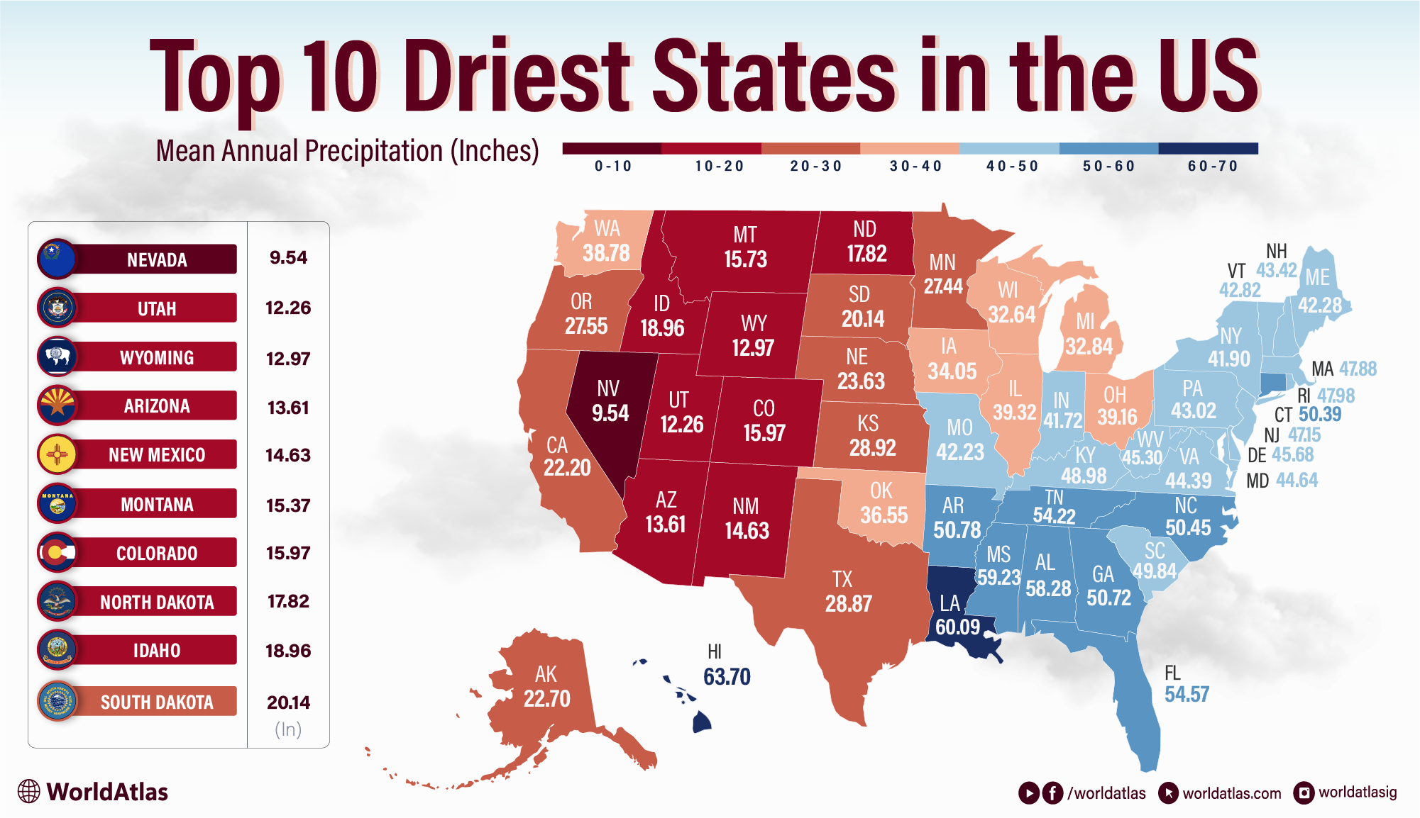
The 10 Driest US States
It’s no surprise that some U.S. states are a little more well-endowed in the precipitation department than others. Follow a few news cycles, and you’ll quickly hear about floods in Florida one day and a moratorium on lawn-watering in California the next. But which states, setting aside the stereotypes, actually see the least annual precipitation? They might not be the ones you expect.
For the purposes of this article, we define the driest states as those that receive the least average annual precipitation.
The 10 Driest US States
| Rank | State | Mean Annual Precipitation (in) |
|---|---|---|
| 1 | Nevada | 9.54 |
| 2 | Utah | 12.2 |
| 3 | Wyoming | 12.9 |
| 4 | Arizona | 13.6 |
| 5 | New Mexico | 14.6 |
| 6 | Montana | 15.3 |
| 7 | Colorado | 15.9 |
| 8 | North Dakota | 17.8 |
| 9 | Idaho | 18.9 |
| 10 | South Dakota | 20.1 |
1. Nevada

No matter what the glittering fountains of the Las Vegas Strip might imply, the state of Nevada does not have abundant water resources. Averaging 9.54 inches of rain annually, it’s the driest U.S. state on record. That’s primarily thanks to the Sierra Nevada Mountains that flank the state on its western border with California, which create a barrier for moist air trying to move over the mountains into Nevada.
As the jet stream travels eastward from the Pacific Ocean, the mountains tend to wring out most of its moisture before it reaches Nevada to the east. This “rain shadow” effect is a common feature of the most arid U.S. states and prevents Nevada from seeing more rainfall. So the next time you see a photo of the glittering fountains and swimming pools of the Las Vegas Strip, remember that it’s a geographic anomaly - Nevada’s water supply is among the smallest in the nation.
2. Utah

It’s the same old story: the large, landlocked states of the Mountain West (of which we’re about to see several consecutively) are prone to aridity by the region’s quirks of geography. As in Wyoming, the rain shadow effect from mountain ranges to the west of Utah keeps its annual precipitation averages very low — 12.2 inches fall annually, to be exact.
This semi-arid climate is very common to states in this region, where any moist air crossing the continent from the Pacific must pass over mountain ranges like the Sierra Nevadas and Cascade Ranges that sap its moisture before it reaches the Mountain West. Although it’s famous as a skiing destination, large parts of Utah are semi-arid or desert, and remembering that goes a long way towards illustrating just how little rain Utah actually receives.
3. Wyoming

Compared to the desert states we’ve seen so far, Wyoming might be a surprising third-place finisher, but it’s much more arid than its reputation for snowy winters might seem to imply. In terms of precipitation, it’s one of the lowest nationwide: with only 12.9 inches of annual precipitation on average, Wyoming just barely edges out New Mexico.
That’s mainly because mountains running up the state’s western edge force moist air from the Pacific Ocean to rise, shedding moisture in the form of precipitation along the way. Thus, by the time it reaches most of Wyoming, that air is very dry and carries little precipitation. It’s worth noting that Wyoming has drier and wetter regions: in the west, on the slopes of its mountain ranges, you’ll see far greater precipitation than you will in its rain shadow to the east. So, though the state’s mountains can be very snowy as a result, Wyoming ranks very low in terms of average annual precipitation.
4. Arizona

Another state known for its aridity, Arizona is not a surprising inclusion on a list of the driest U.S. states. And it’s the fourth-driest in the country: according to NOAA data, only 13.6 inches of annual average precipitation. Rain shadows influence some areas, but Arizona’s low average also reflects its inland location and regional circulation patterns.
Instead, air masses arriving in Arizona often lose moisture crossing California and the Great Basin; Arizona also gets limited moisture from the Pacific and Gulf sources. Of the ten states on this list, not one of them has a seacoast (or is anywhere near one), and that’s not an accident - far-inland states get the dried-out leftovers of the moisture-laden winds blowing in off the ocean, already wrung out by the time they reach Arizona and its fellow landlocked states. Though there is an annual monsoon season that brings occasional summer storms to the region, it’s not enough to bump up Arizona’s standing among the driest U.S. states.
5. New Mexico

All four states in the arid southwestern “Four Corners” region share something besides a border: extremely low average annual precipitation. New Mexico rounds out the top five least-rainy states with an annual precipitation total of roughly 14.6 inches, for many of the same reasons that Arizona and Nevada do: its inland location and the rain shadow effect of the West Coast’s mountain ranges, which tend to dry out westerly winds before they reach New Mexico.
It’s impossible to overstate how key the inland location of New Mexico is in determining how much precipitation it does or doesn’t get. As a general rule, the further moist air has to travel from the coast to reach a destination, the drier it will be by the time it arrives, as it releases moisture along the way, and the less precipitation that region will experience.
6. Montana

Snowy Montana doesn’t seem like a likely contender for the sixth-driest U.S. state, but as we’ve mentioned, almost every state in this region, bounded by the West Coast ranges on one side and the Rocky Mountains on the other, is prone to extremely low rainfall. Those big obstacles, in addition to smaller local mountain ranges, keep the region dry, and Montana is no exception. Because much of Montana lies in rain shadows between mountain ranges, its statewide average precipitation is relatively low.
The northernmost of these states receives an average of 15.3 inches of precipitation per year. You’ll find much higher totals in its mountain ranges, which are known for their heavy snowfall, but as most of the state sits in a rain shadow, the statewide average remains low. Cold, thin, high-altitude air also holds little moisture, making it unusual for Montana to experience rain during its long cold stretches.
7. Colorado

You wouldn’t know it in the storm-battered Rocky Mountains, but much of Colorado receives relatively little precipitation outside the mountains. Try 15.9 inches of average annual precipitation on for size. The major difference here is that Colorado creates its own rain shadow: the Rocky Mountains in the western part of the state tend to suck the moisture out of any incoming air from the coasts, and with much of the state sitting at high altitudes in high altitudes, it remains fairly arid. Naturally, all those famous ski slopes are located in the Rockies - because you’re not going to be seeing that kind of precipitation anywhere else.
8. North Dakota

It’s hard to imagine a state more centrally located than North Dakota, which is so landlocked that it’s almost impossible to get further from the coast at any point in the Lower 48. That winds up being its downfall: any moist air from the coasts has to travel so far and cross so many geographic barriers to wind up in North Dakota that it’s been wrung out like a dishrag by the time it arrives.
The rain shadow of the Rocky Mountains doesn’t help matters, either. North Dakota is a place where almost every rain-stifling geographic effect occurs, from a cold climate and a far-inland location to a rain shadow effect, and it shows in the very low average annual precipitation North Dakota records. In that sense, it’s a fascinating case study in why these ten states receive so little rain; with an average annual precipitation of 17.8 inches, it is the eighth-driest U.S. state.
9. Idaho

Sharing borders with three other states on this list (Nevada, Utah, and Montana), Idaho is well and truly prone to low precipitation. It is subject to the same rain shadow-induced aridity as its neighbors due to its inland location and the mountain ranges to the west, and it averages approximately 18.9 inches of precipitation per year. That said, Idaho’s precipitation varies considerably by region: the mountainous north and the Sawtooth range receive substantially more moisture and heavy winter snowpacks, while large swaths of the southern and central plains are much drier. Those mountain snowpacks are critical, since spring melt and reservoirs supply irrigation water that keeps the state’s agriculture productive and supports towns and recreation economies. Outdoor recreation and tourism around mountain lakes and ski areas, therefore, coexist with the agricultural reliance on managed water supplies.
10. South Dakota

Located just beneath the last entry on this list, South Dakota shares most of the same geographic quirks as its northern neighbor. It’s just as landlocked, northerly, and far from significant sources of moisture. It records a modestly higher average annual precipitation than North Dakota at about 20.1 inches, largely because its more southern latitude allows occasional incursions of Gulf moisture. Within the state, a clear east-west contrast is evident: the wetter eastern plains are productive cropland, where corn, soy, and hay are common, while the western portion, especially the Black Hills, receives higher precipitation and supports forests, springs, and year-round tourism. Rivers such as the Missouri help shape local microclimates and provide essential water resources for towns, farms, and wildlife, even as much of the state remains comparatively dry.
The Driest States In The United States
Are you surprised by the U.S. states that receive the least annual precipitation? While some desert states probably won’t come as a surprise, it’s interesting to note how many of these states don’t seem arid at all. Many are even known for heavy snowfall, prime ski destinations you’d never classify as deserts. Most, if not all, are dry for two major reasons: mountainous terrain and an inland location. (Notice the lack of coastal states?)
Geography is tricky like that: it’s not only the desert that rarely sees precipitation. It’s often the most landlocked and mountainous regions that are most likely to go months without a storm. And local variation means that some of the driest states aren’t popularly perceived that way at all. This all goes to demonstrate that, when you average out the precipitation totals across entire states, you’ll find surprising patterns.
US States Ranked By Mean Annual Precipitation
| Rank | State | Mean annual precipitation (inches) |
|---|---|---|
| 1 | Nevada | 9.54 |
| 2 | Utah | 12.26 |
| 3 | Wyoming | 12.97 |
| 4 | Arizona | 13.61 |
| 5 | New Mexico | 14.63 |
| 6 | Montana | 15.37 |
| 7 | Colorado | 15.97 |
| 8 | North Dakota | 17.82 |
| 9 | Idaho | 18.96 |
| 10 | South Dakota | 20.14 |
| 11 | California | 22.20 |
| 12 | Alaska | 22.70 |
| 13 | Nebraska | 23.63 |
| 14 | Minnesota | 27.44 |
| 15 | Oregon | 27.55 |
| 16 | Texas | 28.87 |
| 17 | Kansas | 28.92 |
| 18 | Wisconsin | 32.64 |
| 19 | Michigan | 32.84 |
| 20 | Iowa | 34.05 |
| 21 | Oklahoma | 36.55 |
| 22 | Washington | 38.78 |
| 23 | Ohio | 39.16 |
| 24 | Illinois | 39.32 |
| 25 | Indiana | 41.72 |
| 26 | New York | 41.90 |
| 27 | Missouri | 42.23 |
| 28 | Maine | 42.28 |
| 29 | Vermont | 42.82 |
| 30 | Pennsylvania | 43.02 |
| 31 | New Hampshire | 43.42 |
| 32 | Virginia | 44.39 |
| 33 | Maryland | 44.64 |
| 34 | West Virginia | 45.30 |
| 35 | Delaware | 45.68 |
| 36 | New Jersey | 47.15 |
| 37 | Massachusetts | 47.88 |
| 38 | Rhode Island | 47.98 |
| 39 | Kentucky | 48.98 |
| 40 | South Carolina | 49.84 |
| 41 | Connecticut | 50.39 |
| 42 | North Carolina | 50.45 |
| 43 | Georgia | 50.72 |
| 44 | Arkansas | 50.78 |
| 45 | Tennessee | 54.22 |
| 46 | Florida | 54.57 |
| 47 | Alabama | 58.28 |
| 48 | Mississippi | 59.23 |
| 49 | Louisiana | 60.09 |
| 50 | Hawaii | 63.70 |