Which Countries Have Coastlines On The Timor Sea?
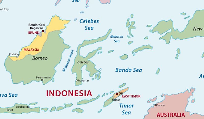
The Timor Sea is a sea within the Indian Ocean that encompasses an area of approximately 240,000 sq mi and has a maximum with of about 300 mi. The sea is bounded by the island of Timor to the north, Australia to the south, the Arafura Sea to the east, which is part of the Pacific Ocean, and the Indian Ocean to the west. The Timor Sea is influenced by the monsoon belt and southeast trade winds, and often generates typhoons. The sea also contains significant oil reserves, which have caused territorial disputes between Australia and Timor-Leste (East Timor).
Oil and Gas Reserves in the Timor Sea
The Timor Sea holds vast reserves of oil and gas. The first oil well was drilled in 1974, and the sea now contains several offshore projects, as well as significant exploration activity. A gas pipeline now crosses the Timor Sea, from the Joint Petroleum Development Area (JPDA) to Wickham Point, which is located near Darwin, Australia. A large oil spill occurred in the Timor Sea in 2009, lasting for a period of 75 days (21 August 2009 until 3 November 2009), during which the Montara oil field spilled more than 400 barrels of oil each day for the duration of the incident. The Australian Government's Montara Commission of Inquiry was created to investigate the incident, and ultimately blamed PTT Exploration and Production (PTTEP), a company based in Thailand that owned the oil wells. The Bayu-Undan project is currently the largest oil project in the Timor Sea, which is located 310 mi northwest of Darwin. Production in the Bayu-Undan project began in 2004 and is expected to operate until 2023.
Territorial Disputes Over the Timor Sea
Several disputes over the Timor Sea have occurred since oil was discovered in the 1970s. Such disputes are generally related to rights regarding the exploitation and ownership of oil resources in the Timor Gap, which is a part of the Timor Sea. The region lies outside the territorial borders of countries north and south of the Timor Sea. Early disputes involved Indonesia and Australia, which were eventually resolved through the Timor Gap Treaty, signed in 1989. However, East Timor gained independence from Indonesia in 1999, and the terms of the treaty were abandoned. New negotiations between Australia and East Timor commenced, leading to the signing of the Timor Sea Treaty in 2002.
Between 1965 and 2018, the territorial claim of Australia extended to the Timor Trough, which is the deepest part of the sea, and overlapped East Timor's claim that was based on the United Nations Convention on the Law of the Sea (UNCLOS) stating that the boundary should be halfway between the two countries. On March 6th, 2019, Australia and East Timor signed an agreement, the Australia-Timor Leste Treaty Establishing Their Maritime Boundaries in the Timor Sea, defining the boundary as the halfway point between them, and detailing how resources in the Timor Sea would be shared.
Australia-East Timor (Timor-Leste) Relations
Australia and East Timor have close trade and political ties. East Timor is the youngest nation and one of the poorest in Asia and Australia, and its neighbor is a developed country that has played a significant role in the history of East Timor. During the first decade of East Timor's independence, Australia has supported the country is the largest bilateral donor of development aid. Australia has also offered assistance in the form of leadership, to ensure stability and security in East Timor.


