Which Countries Border Laos?
Officially known as the Lao People's Democratic Republic, Laos is a socialist nation located in Southeast Asia at the center of the Indochinese peninsula. Within the region of Southeast Asia, it is the only landlocked country. The independent republic is bordered by 5 neighboring nations. Thailand borders Laos to the southwest and west while Cambodia also lies to the southwest. China and Myanmar (Burma) form the northwest boundary while Vietnam is to the east. The nation has an approximate area of about 91,875 square miles, which makes it the 82nd largest country in the world. The unique location at the heart of Southeast Asia makes it a kind of buffer between the surrounding powerful states. The uniqueness is increased by the fact that the country was closed off to tourism until the later stages of the 1990s.
Borders of Laos
Laos–Thailand Border
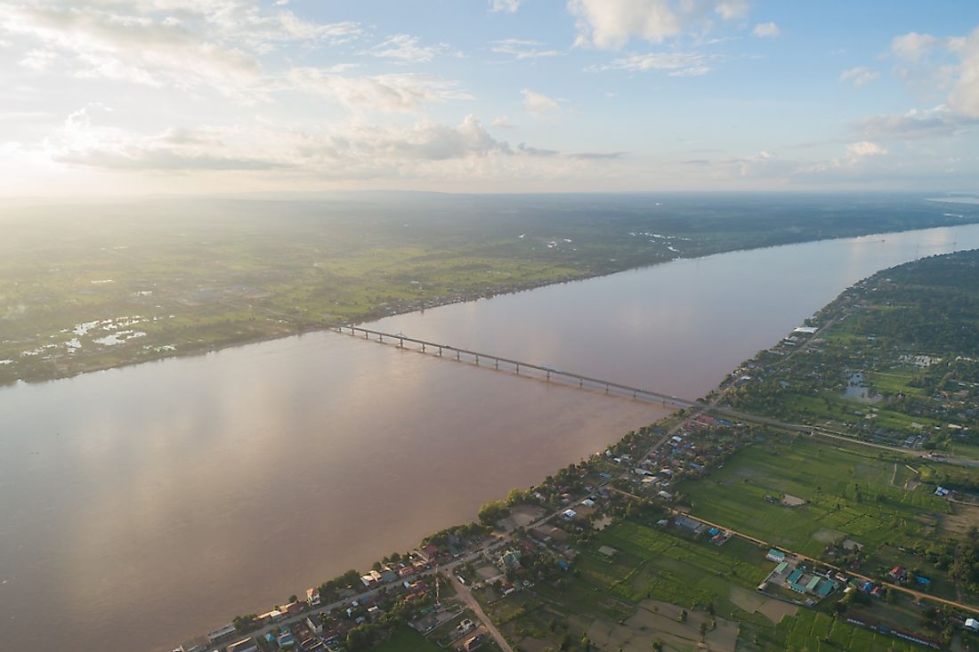
On the Laos side, some of the border crossings include places such as Ban Houayxay, the Chiang Khong District, Mukdahan, Nakhon Phanom, and Nong Khai. One of the popular border crossings, at the Chiang Khong District, has a river known as the Mekong River that forms part of the border. Anyone wishing to cross the border will have to cross the river. As part of aid from the Australian government to Laos, a bridge was built back in the 1990s and was opened on April 4, 1994. The bridge, which is known as the First Thai–Lao Friendship Bridge, connects Thailand’s Nong Khai Province to the Laos city of Vientiane. The two regions are about 12 miles apart but the bridge itself has a length of about 0.73 miles, a dual lane for vehicles, and a railway line. In total, there are five Thai-Lao friendship bridges.
In the past, the two countries have had some minor conflicts including the Thai–Laotian Border War, which took place between December 1987 and February 1988. The short-lived dispute arose due to a survey by the French in 1907 who marked the borders between French Indochina and Siam on the southern region of the Luang Prabang Range. These surveyors did not clarify the issue of ownership of three small border villages in Uttaradit Province and the village of Ban Romklao in Phitsanulok Province. Prior to this small issue, there were a couple of minor conflicts between the two countries in 1984 over the villages. However, in 1987, Thailand sent troops to Ban Romklao to occupy the village and erect the Thai flag. Naturally, the government of Laos came out strongly against the act while claiming that the village was part of Laos while Thailand insisted that the village belonged to Thailand. Eventually, the two countries went to war in the same year in a conflict that claimed the lives of about 1,000 people with heavier losses on the Thai side. After the in 1988, the two countries established the Thai-Lao Joint Boundary Commission in 1996 to sort out the issue. As of 2007, the issue had not yet been fully resolved with border markings still in progress.
Laos-Cambodia Border
This border is formed by two rivers namely the Kong and the Mekong River. The Kong River begins its course at the province of Thừa Thiên-Hu in Vietnam before linking up with the Mekong River near Cambodia’s Stung Treng. Despite having a good relationship, the two countries have always had tensions over the 139-mile long border. The border dispute is for a region located in the province of Stung Treng. Efforts to mark the border began in 2000 after two decades of unrest. Recently, in April 2018, Lao authorities closed the border after claiming that Cambodian soldiers had built an outpost in the disputed area. The latest development is that the two countries have agreed to cooperate to come up with a solution.
Laos-China Border
This border is about 262 miles separating the Laotian provinces of Oudomxai, Luang Namtha, and Phongsali from the province of Yunnan of China. In some parts, it acts as a triple border with Vietnam and Myanmar. In the past, when France granted Laos partial independence in 1949, China adopted Maoism (a form of Stalinist principles) after the establishment of the People's Republic of China by Mao Zedong. The adoption of Maoism affected Laos in a way that led them to demand total independence, which was attained in 1953. The two countries also participated in the 1964 Vietnam War.
Laos-Vietnam Border
This border can be crossed at several points such as Dong Ap Bia, Phu Xai Lai Leng, Rào Cỏ Mountain, Sepon River, and Shiceng Dashan. Historically, the border relations between the two countries have been rocky going all the way back to Laotian and Vietnamese kingdoms. In modern times, the relations between the two were set up in such a way that Laos’s relations with Thailand and China would not be friendly. The Lao People's Revolutionary Party (LPRP), which had considerate influence in Laos, took a lot of advice from Vietnam without the knowledge of the public. Eventually, during the Vietnam War, the Vietnamese turned on Laos and ended up attacking Laotian villages. After that period, the relations between the two countries have improved as evidenced by several things such as commerce, which equated to about $725 million in 2012.
Laos-Myanmar Border
This border is primarily formed by the Mekong River, which flows in at least three countries namely China, Laos, and Myanmar. The river first meets the tripoint of the aforementioned countries and then flows southwest for a stretch of about 62 miles, which forms the border between Myanmar and Laos. In addition to the border between Lao and Myanmar, the river also forms part of the border between Laos and Thailand.
The relations between the two countries have been improving in recent times as shown by things like opening a friendship bridge linking the two countries. The bridge, which acts as a link between Tachileik in Myanmar and the Luang Namtha Province of Laos, was opened by the presidents from the two countries to mark 60 years of diplomatic relations. The bridge also acts as a symbol of the desire for the two countries to increase cooperation in things like tourism, investment, and trade.


