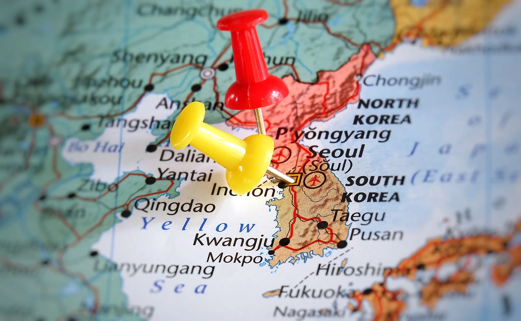
Korean Peninsula
Asia, the world’s largest continent by area and population, comprises several peninsulas extending into the surrounding water bodies. Both world’s largest peninsula (Arabian Peninsula) and the only peninsula recognized as a sub-continent (Indian Sub-continent) form part of Asia. Most Asian peninsulas have played essential roles in defining the continent’s history and cultural influence.
One of Asia’s main peninsulas is the Korean Peninsula, located in East Asia. It is a large landform that extends about 1,100 kilometers into the Pacific Ocean from the mainland continent. The Korean Peninsula is famous for many things, including its role in the surrender of Imperial Japan, which led to World War II’s formal end.
Content:
- Location Of The Korean Peninsula
- Korean Peninsula Countries
- Origin Of Name
- Important Geographical Features
- Climate
- Plants And Animals
- History Of Human Settlement In The Korean Peninsula
- Important Population Centers
- Economy
Where Is The Korean Peninsula?
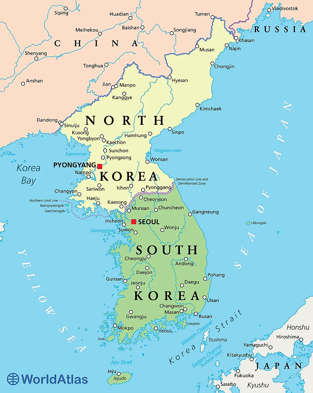
The Korean Peninsula is located in East Asia and covers an estimated 223,155 km2. The peninsula and the nearby islands, including Jeju Island, Dokdo, and Ulleung, are collectively referred to as Korea. The Korean Peninsula (excluding the surrounding islands) covers an estimated 220,847 km2. From mainland Asia, the peninsula extends for about 1,100 km into the Pacific Ocean.
The Korean Peninsula is surrounded to the west by the Yellow Sea and to the east by the Sea of Japan. The two seas are connected by the Korean Strait. The peninsula is separated from China by the Amnok River, and from Russia and China by the Duman River. The Sea of Japan and the Korean Strait also separate the peninsula from Japan.
Korean Peninsula Countries
The Korean Peninsula is shared by two sovereign states; South Korea and North Korea. The two countries were created in 1945, following the surrender of Imperial Japan. The surrender led to the partitioning of the peninsula into two, with the Soviet Union occupying the north and the US taking up the south. The two superpowers differed on ideologies. The Soviet Union supported communism in the north, while the south was pro-western. The Ideological differences led to the division of Korea into South Korea and North Korea counties in 1948.

North Korea covers the northern part of the Korean Peninsula. It is the larger of the two countries on the peninsula, covering approximately 120,540 square kilometers. As a northern state, it is nearest to mainland Asia. It is bordered by Russia and China to the north, along the Amnok River.

South Korea occupies the peninsula’s southern portion and is separated from North Korea by the Korean Demilitarized Zone. The Korean Strait separates South Korea from Japan.
Origin Of Name
The name “Korea” was coined from the name “Goryeo,” used by the ancient Goguryeo kingdom. In the first millennium, the Korean Peninsula was dominated by three states; Silla, Baekje, and Goguryeo, collectively referred to as the Three Kingdoms of Korea. Silla would later conquer the other two states and form a “Unified Silla.” Towards the end of the millennium, Goguryeo revived as Goryeo, unified the peninsula as a single state. The Persian merchants who visited the peninsula referred to it as “Korea.” The name “Goryeo” is a combination of two words; “go” which means “high” or “lofty,” and the name of a local tribe known as Yemaek (originally known as “Guru,” meaning walled city).
Important Geographical Features
The Korean Peninsula is located in East Asia between Japan and China. It is characterized by varied topography and geographical features, including plains, mountain systems, and rivers. The southern and western portions comprise well-developed plains, while the northern and eastern portions are mainly mountainous.

Mountains cover approximately 70% of the Korean Peninsula. Although most of the mountains are located in South Korea, the majority of the tallest mountains are in North Korea. At 9,003 feet, Mount Paektu is Korea’s tallest mountain. It is located in North Korea’s Ryanggang Province and forms part of the Korea-China border. Other significantly tall mountains on the peninsula are Mount Jiri, Mount Seorak, Mount Taebaek, and Mount Kumgang.
Since most mountainous regions are on the eastern side of the peninsula, most rivers tend to flow towards the west. The Amnok River (795 km long) and Tumen River (521 km) forms the boundary between the Korean Peninsula and China. Both rivers rise from the Paektu Mountain. Nakdong River is South Korea’s longest river and the peninsula’s third-longest river after Amnok. It rises from Taebaek Mountain and flows for about 510 kilometers into the Sea of Japan. Other rivers include the Han River, Taedong, Chongchon, Yeongsan, and Geum Rivers.

The peninsula has coastlines on the Yellow Sea, East China Sea, and the Sea of Japan. Most Korean coastlines are well-developed, forming a ria coastline. The complex coastline causes the sea to become mild sea, making navigation safer.
Climate
The Peninsula’s climate varies from north to south, with the southern region experiencing warmer and wetter climates like Japan, while the northern regions experience a colder climate. The warm and wet climate in the north results from warm ocean waters. However, the whole peninsula is characterized by similar climatic patterns, such as the East Asian monsoon.
Korea receives most rainfall during the summer seasons due to the mixing of hot and humid air from the Pacific and wet air originating from the Sea of Okhotsk. In winter, Siberia, dominates the weather, causing temperatures to drop. However, precipitation in winter is minimal.
Plants And Animals

There are more than 3,000 floral species on the Korean Peninsula, including 500 endemic species. The floral species are grouped into three zones; temperate, cold-temperate, and warm-temperate zones. The temperate zone is the largest floristic province, covering most of the peninsula. The Korean pines and other deciduous trees dominate the temperate zone. Other common plant species found on the peninsula include birch, maple, poplar, ash, and oak. Alpines are common on highlands, while coastal areas feature citrus plants.

Korea’s endemic fauna species include Korean water deer, Korean hare, Korean brown frog, and Korean Spruce. The Demilitarized Zone is a biodiversity hotspot, with over 70 mammals and 300 avian species. It contains the Amur leopard, among other endangered species. The aquatic species include over 200 freshwater species, such as marbled eel, Manchurian trout, and spotted barbell. Marine species include Korean rockfish and Korean skate.
History Of Human Settlement In The Korean Peninsula

The earliest known human settlement on the Korean Peninsula dates back to the Neolithic period. It was first inhabited around 10,000 BCE by people whose livelihoods depended on fishing, hunting, and gathering. The first settlement may have been established around 6,000 BCE, with villages located on the foot of mountains and hillside.
Around 2333 BCE, Dangun, Heaven’s descendant, established the Gojoseon. Gojoseon prospered on the peninsula until it was conquered by China’s Han Dynasty in 108 BCE. The Hans took control of the northern part and installed their commanderies. Later, the northern Korean Peninsula became Goguryeo, while the southern part was split into Byeonhan, Jinhan, and Mahan. These three confederacies existed during the Proto-Three Kingdom Period. The confederacies eventually developed into Gaya, Silla, and Baekje. Silla, Baekje, and Goguryeo became the dominant states during the Three Kingdom Period.
However, Silla conquered the other two states and established “Unified Silla” over the peninsula. Goryeo Dynasty replaced Silla by as Korea’s ruling dynasty in 918. Joseon Dynasty overthrew Goryeo Dynasty in 1392 and established the Korean Empire in 1897. The Japanese occupied Korea from 1910 until their surrender in 1945, in the aftermath of World War II. Three years later, South and North Korea were established.
Important Population Centers

The Korean Peninsula is home to an estimated 76 million people. South Korea is the most populated of the two countries, with about 51 million people. The peninsula’s population also comprises immigrants from neighboring countries, particularly China and Japan. Seoul, South Korea’s capital, is the largest city on the peninsula, with over 25 million residents, making it the world’s 4th largest metropolitan area. Other population centers in South Korea are Daejeon (1.5 million), Daegu (over 2.5 million), Incheon (three million), and Busan (about four million).
North Korea’s population is approximately 25 million people. Pyongyang is the capital and largest city, with an estimated population of 3.3 million people. Other main population centers in North Korea are Hamhung (560,000), Namp’o (450,000), and Sunch’on (440,000).
Economy
The Peninsula’s economy can be described as the economy of South and North Korea. North Korea has a closed and centralized economy. It is a semi-industrialized country, with half of its GDP generated by the industries. However, it has a low GDP per capita of $1,800. The economy is highly nationalized and characterized by free healthcare and education. More than 60% of the workforce are employed in industries. The country’s major industries include mining, chemical, food processing, and textile.
South Korea is a highly-industrialized and developed country. Its economy is mainly driven by the skilled workforce, making it one of the top technological powerhouse. South Korea is one of the countries with the fastest-growing GDPs, which currently stands at $1.6 trillion. The country’s economy depends mainly on international trade, with its products such as Samsung and LG Electronics dominating the international market.
South Korea is one of the top nuclear power producers. Its nuclear powers account for 45% of its electricity supply. It is also a major exporter of nuclear reactors and has agreed with countries like Jordan, the UAE, and Turkey to construct and maintain atomic piles.
Tourism is a thriving economic activity on the peninsula, with over 20 million people visiting Korea annually. Tourism is promoted by several factors, including the rich Korean culture, pristine beaches, rich wildlife, and fascinating landscape.


