What Is A Peninsula?
A peninsula is a unique geographic formation that extends from a large mainland area into the nearby water source. This formation is similar to an island, however, it is only surrounded by water on 3 sides. An island, in contrast is an independent geographic formation that is completely surrounded by water. Peninsulas are often referred to as capes, although some individuals differentiate between the two by claiming that a cape is a smaller piece of land that extends from the peninsula. The water surrounding a peninsula may be a river, lake, ocean, or sea. Other terms for peninsulas include: promontories, spits, points, and headlands.
Peninsulas are located all over the world and on every continent. In fact, some researchers classify the entire European continent as a peninsula. This geographic formation may be extremely large or very small. Additionally, peninsulas often house lighthouses in order to prevent shipwrecks. This article takes a closer look at how peninsulas are formed and where they are located around the world.
How is a Peninsula Formed?
Peninsulas may be formed by one of several manners. One of the ways peninsulas come to exist is by the movement of lithospheric tectonic plates. These plates are susceptible to changes in movement at the core of the earth and may shift. Over a long period of time, this movement stresses the underlying rock, creating cracks which cause the land above them to be pushed or pulled in a variety of directions. One of the results of geographic activity can be peninsulas.
Another way that peninsulas are formed is by changing levels in water. Water rising against land and slowly receding over a number of years causes erosion, which may result in peninsula formation. Additionally, melting glaciers and increasing storms contribute to rising sea levels, which often surround land masses on just a few sides.
Where is the Largest Peninsula?
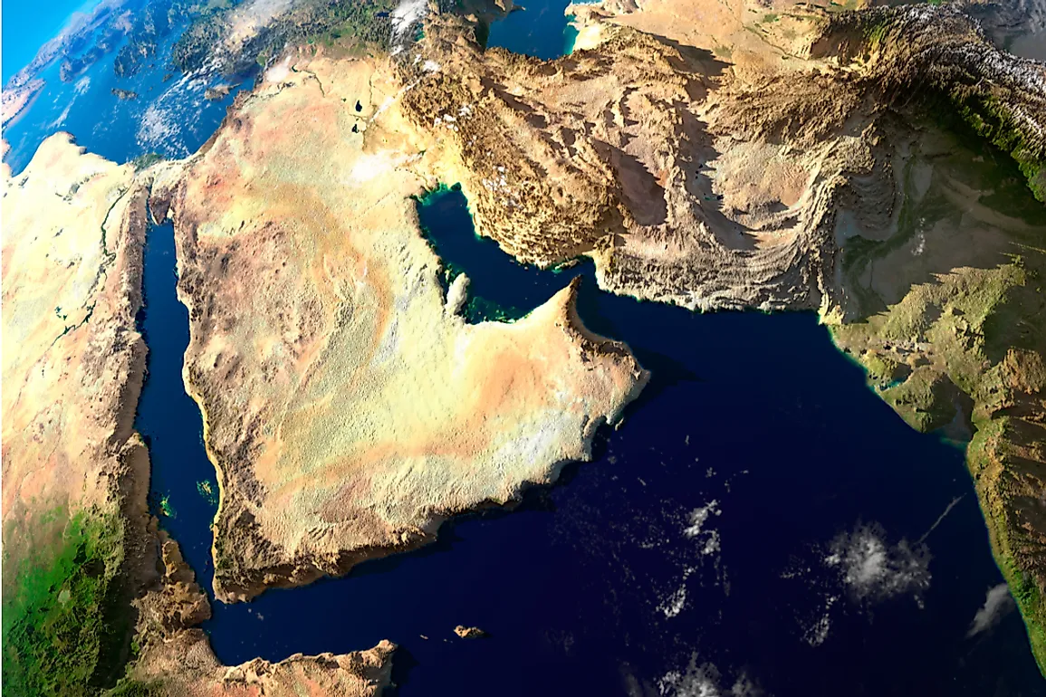
The Arabian Peninsula is the largest peninsula in the world. It covers a total area of 1,250,006 square miles. This peninsula is located to the southwest of the mainland Asian continent and is often referred to as a subcontinent of Asia because of its size. It is surrounded by several bodies of water, including the Persian Gulf, the Arabian Sea, and the Red Sea. The northern edge of the Arabian Peninsula connects to the Arabian Desert and acts like an unofficial border between Saudi Arabia and Kuwait.
The landscape within the Arabian Peninsula is quite diverse and includes several geographic features, such as: a central plateau, vast deserts, the Hejaz mountain range, and a marshy coastland. The climate here is harsh with hot temperatures and an arid atmosphere. These desert conditions make the peninsula unfit for any significant agricultural production. Residents here, however, do commonly raise livestock animals like goat, sheep, and camel, for example.
Seven distinct countries are completely located within the Arabian Peninsula: Kuwait, Saudi Arabia, Yemen, United Arab Emirates, Oman, Bahrain, Qatar. Two other countries have some land within the peninsula as well: Iraq and Jordan. The Arabian Peninsula is an important global source of oil and natural gas; this industry makes up a large part of the economic activity here. Additionally, countries within this peninsula have active construction and development sectors as well as large financial services industries.
Other Peninsulas Around The World
As previously mentioned, peninsulas can be found on every continent around the world. Below is a look at one peninsula from each of the remaining continents.
In North America
One of the most well-known peninsulas in North America is Baja California, which is located just to the south of the US state of California. It is the northernmost territory in Mexico. To the west of this peninsula is the Pacific Ocean and to the east is the Gulf of Calfornia. It covers a total area of 55,360 square miles, stretching 775 miles from north to south and anywhere from 25 to 200 miles in width. Politically, the Baja California Peninsula is divided into 2 states: Baja California and Baja California Sur. Ecologically, it is divided into 8 regions. The majority of its territory is comprised of deserts, although the peninsula is also home to pine-oak forests and xeric shrublands.
In Africa
The Horn of Africa is one of the best-known peninsulas on the African continent. It is located on the eastern coast of the continent, north of the central region. Just to the south of the Gulf of Aden, the Horn of Africa is surrounded by the Indian Ocean and the Arabian Sea. It covers a total area of 770,000 square miles. Politically, the Horn of Africa is divided into 4 countries: Somalia, Ethiopia, Djibouti, and Eritrea. Together, these countries have a combined population size of 115 million.
The vast majority of the area of the Horn of Africa consists of mountain ranges. These mountains were created millions of years ago by the same tectonic plate movement that resulted in the Great Rift Valley. The mountainous areas in Ethiopia receive a significant amount of rainfall every year, which supplies a large portion of Africa with water. Many of the areas here, however, are dry and receive very little rainfall. This is particularly true of the lowland regions, where the temperature is hot and the climate is arid. One of the biggest desert ecoregions on the Horn of Africa is the Danakil Desert, which covers a total area of 38,610 square miles. The Horn of Africa is home to a wide range of biodiversity, including 5,000 plant species, more than 285 reptile species, 220 mammal species, and 100 freshwater fish species. A large percentage of these species are endemic to the area. In fact, the Horn of Africa has the highest number of endemic reptiles found anywhere else on the continent.
In Australia
One of the most widely recognized peninsulas in Australia is the Cape York Peninsula. This geographic formation is located in the northern part of the country and is part of Far North Queensland. This peninsula is surrounded by the Coral Sea and the Gulf of Carpentaria. It covers a total area of around 111,508 square miles.
The Cape York Peninsula is covered in tropical rainforests, shrublands, sub-tropical grasslands, rivers, mangroves, and eucalyptus-filled savannahs. It is considered one of the last true wilderness areas on earth, although its ecological balance is threatened by invasive species and grazing livestock. Because of this wide range of ecosystems, Cape York Peninsula is home to over 700 vertebrate animal species, many of which are endemic. Additionally, around 200 butterfly species can be found in its rainforest.
In Europe
In Europe, one of the most recognizable peninsulas is the Apennine Peninsula, also known as the Italian Peninsula. This peninsula has one of the unique shapes of the large peninsulas and is often said to look like a boot. It covers a total area of 50,709 square miles and is bordered by 3 seas: the Adriatic, the Tyrrhenian, and the Ionian. Politically, the Italian Peninsula is divided into Italy (which lays claim to the vast majority of the area), the Vatican City and San Marino Much of the Italian Peninsula is covered by the Apennine mountain range.
In South America
The Brunswick Peninsula is one of the largest peninsulas in South America. It is located off the coast of Chile in the Patagonia region. This peninsula covers an area of approximately 2,400 square miles, stretching 71 miles in length and between 50 and 9.9 miles across. Interestingly, the Brunswick Peninsula encompasses the southernmost point in the Americas. Politically, it is known as the Punta Arenas region. The only city located here is Punta Arenas, which is the capital of the region. Geographically, several islands are also considered part of the Brunswick Peninsula. These islands include the: Clarence Island, Dawson Island, Desolación Island, and Capitán Aracena Island.
In Antarctica
The only not continuously inhabited peninsula mentioned in this article is the Antarctic Peninsula. It is also the only peninsula mentioned that is constantly covered in an ice sheet. The Antarctic Peninsula is located at the bottom of the Southern Hemisphere and juts off the northernmost part of the Antarctic mainland. It is the largest peninsula on this continent, stretching for around 810 miles in length. The Antarctic Peninsula is home to a number of scientific research stations. Currently, it is under a land dispute between the UK, Chile, and Argentina, all of which lay claim to the area.