River Thames
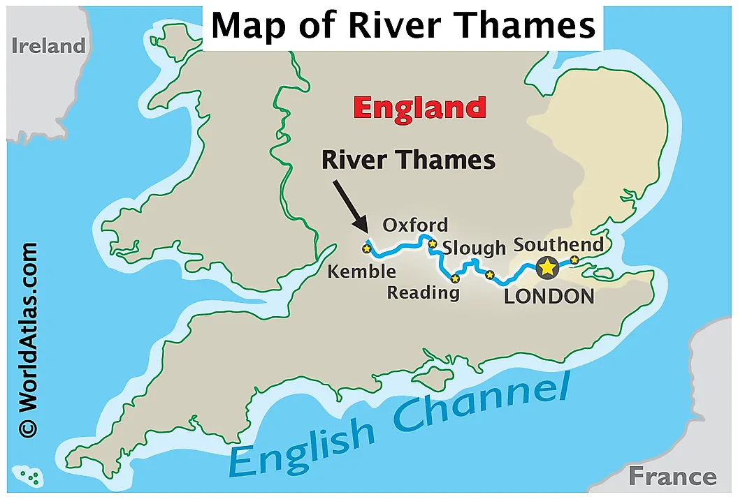
The River Thames is a 346 km river that flows through southern England, starting from Thames Head in Cotswold Hills, Gloucestershire County. It is the longest river in England and the second longest in the United Kingdom right after the River Severn. The river passes numerous popular cities, such as London, Reading, Hendley-on-Thomas, Windsor and Oxford, where it is also called the Isis River, and flows into the North Sea via the Thames Estuary.
Origin Of Name
The Thames is derived from a Middle English term, Temese, which is also derived from the Brittonic Celtic name, Tamesas, which could mean “dark”. Flowing through Oxford, the River Thames was also called the Isis. This was due to the fact that gazetteers and cartographers in Victorian times insisted that the river be named the Isis from its source until Dorchester on Thames in Oxfordshire. Ordnance Survey maps, the national mapping agency for Great Britain, still labels the Thames as the River Thames or Isis until Dorchester. However, some historians suggest that the name Isis is merely a truncation of Tamesis, the Latin name for the Thames. It was also named the “London River” by merchant seamen and Londoners often referred to it as “the river”.
The Thames River Basin

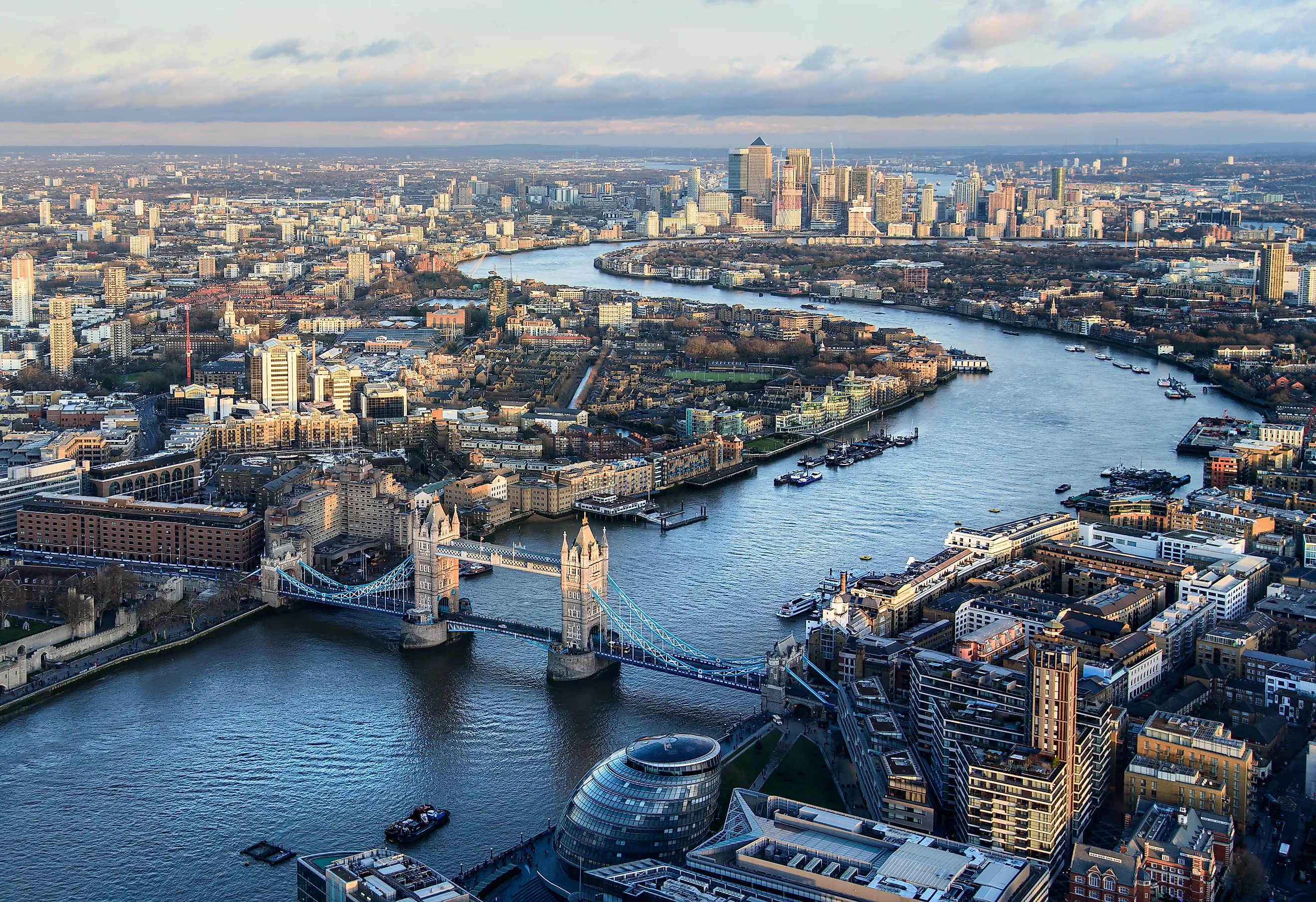
The Thames’ basin covers an area approximately16,130 km2 and includes both rural and heavily urbanized areas in the east and northern parts. However, the western parts of the catchment area are mainly rural. The conventionally known source of the River Thames, the Thames Head, is marked with a stone and is dry most of the year. However, there is some controversy about the actual source of the Thames, as it argued that the Churn River might be the origin of the river. Remarkably, the Thames provides two-thirds of London’s drinking water. There are 16 bridges that cross the River Thames in Greater London alone, most prominently the Golden Jubilee Bridges and the Millennium Bridges for pedestrians.
The Nore is the sandbank that marks the mouth of the Thames Estuary and the confluence point of the Thames and the North Sea. The river is divided into two sections: tidal and non-tidal. The Tideway is the river’s lower reaches (below Teddington Lock), which has tidal reaches up to Teddington Lock. This section of the River Thames is subject to tides from the North Sea and includes the upper Thames Estuary in addition to the Pool of London. Moreover, the tidal section includes the driest parts of mainland Britain and includes most of London. The tidal limit, which marks the end of the tidal effect, is at Teddington Lock, hence extending the non-tidal section between the Thames’ origin and Teddington Lock. Despite the tidal limit, high tides in the spring can raise the head water level in the reach above Teddington and can reverse the river flow for a limited time. This non-tidal section includes 38 tributaries that feed the Thames.
Geology
The River Thames is estimated to have started flowing 58 million years ago as a discrete drainage line in the Thanetian stage of the late Paleocene epoch. The Thames first flowed on its existing course through what is now Oxfordshire before changing its course 500,000 years ago, turning to the north-east through Hertfordshire and East Anglia, ending at the North Sea near Ipswich in Suffolk, England. This change in course was caused by the bursting of large ice lakes’ banks during the Ice Age, about 450,000 years ago. At that time, the Anglian ice advance resulted in a new route for the Thames through Berkshire and on into London, then the river rejoined its original course in southern Essex near the present River Blackwater estuary. At this point, the Thames entered a freshwater lake in the southern North Sea basin. The lake overspilled and caused the formation of the Channel River and then the Dover Strait gap between modern-day Britain and France.
Brickearth can be seen interlaid with the clay on the valley sides of the Thames and some of its tributaries. These deposits were brought by the winds during the periglacial periods, meaning that marshes were actually part of the landscape. The Thames lies within a chalk trough, and geological deposits comprise London Clay. This clay was formed 60-50 million years ago when Britain was still submerged in tropical seas.
Wildlife

The Thames is a common place for various species of birds that either feed off the river or nest on it. These include the cormorant, black-headed gul and the herring gull. A rare type of swan, called the black swan, can also be seen there. In addition to those, there are many non-native birds that can be seen there such as the Canada geese, Egyptian geese and bar-headed geese. Having both freshwater and seawater in different sections, the Thames supports many populations of fish. However, these populations are at risk due to pollutants leaking into the river. Freshwater fish include brown trout, chub, dace, roach, barbel, perch, pike, bleak and flounder. Short-snouted seahorses have also been discovered in the river. Moreover, the Thames Estuary is home to many aquatic animals such as the grey and harbour seals, which have been seen upriver in Richmond. Bottlenose dolphins and harbour porpoises are also common in the Thames.
Human Activity And Economy

The River Thames was considered an economic resource throughout history as it served to be a maritime route, a boundary, a fresh water source and a source of food. Evidence dating back to Neolithic times proves that humans were benefitting off the river along its length, including excavations from Dorney Lake near the Thames. Bronze Age sites and artifacts have been also discovered along the banks of the river including settlements at Lechlade, Cookham and Sunbury-on-Thames. The Thames became the busiest waterway by the 18th century, as London became the center of the British Empire and the hub of most economic activities. However, the advancement of transport and decline of the Empire in the 20th century reduced the economic importance of the river.


