What Is an Anticyclone?
Description
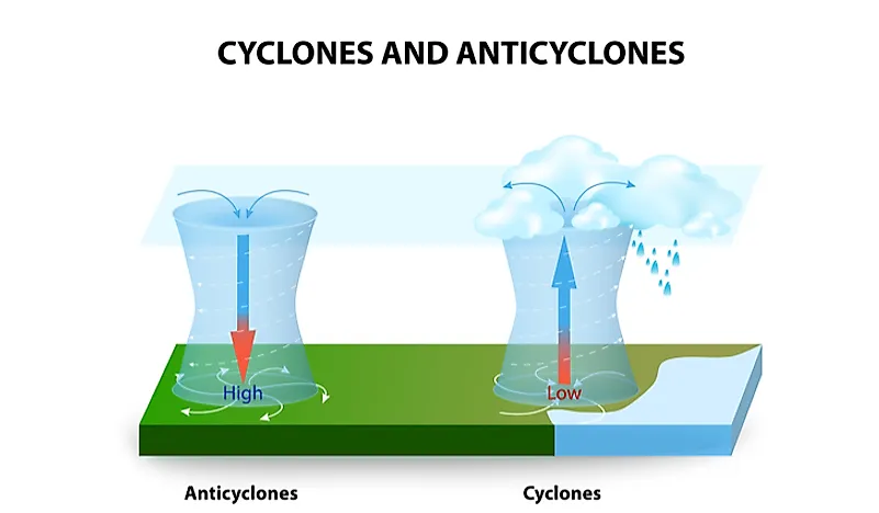
An anticyclone is a large scale circulation of winds around an a center point of high atmospheric pressure. This type of weather phenomenon is the opposite of a cyclone, which rotates around a central region of low pressure. According to the United States National Weather Service (NWS), the winds of an anticyclone rotate clockwise in the Northern Hemisphere and counterclockwise in the Southern Hemisphere. There are three types of anticyclones: surface-based systems, mid-tropospheric systems, and upper tropospheric systems. Anticyclones can also occur on other planets, such as Jupiter, where there are two types, namely the Oval BA and Great Red Spot anticyclones.
Strength and Direction
The winds of an anticyclone typically blow from regions of high pressure towards regions of low pressure. The difference in pressure between the two areas usually determines the strength of the winds. Therefore, a greater difference means that winds will travel at higher speeds, and vice versa. The Earth’s rotation generates a Coriolis force that is responsible for the clockwise and anticlockwise directions of anticyclones in the Northern and Southern Hemispheres. The outward movement of an anticyclone from its central region is caused by friction with land.
Effects of Anticyclones
Surface-Based Systems
The effects of anticyclones depend on the type of system. Surface-based systems usually result in warm air masses, surface winds, and clear skies. These warm air masses are caused by air subsidence that arise from high sections of the troposphere. Clear skies mean that there are no clouds to reduce the amount of sunshine reaching the Earth, which translates to high temperatures on the surface. At night, the cloudless skies mean that heat energy from the surface does not encounter any blockages, which translates to all seasons having cooler diurnal low temperatures. In some cases, fog can form overnight if the relative humidity gets close to 100%.
The origin of a surface-based anticyclone will also determine the type of weather it causes. High-pressure systems building from the north and moving towards the south are cooler at the base, which leads to clear weather, and the cooler base prevents the formation of clouds. On the other hand, for example, high pressure in warmer coastal areas has the potential to bring moisture to an area since the systems move over warm moist oceans.
Mid-Tropospheric Systems
The circulation of air in middle parts of the troposphere can prevent the mixing of air from the lower and the middle parts of the troposphere. Consequently, thunderstorms are immensely reduced, while pollutants such as ozone are trapped at the base of the troposphere. These trapped pollutants causes some areas to have unbearable heat during summer months. Examples of such places include Los Angeles, California and Mexico City, Mexico.
Upper Tropospheric Systems
High-pressure systems at high elevations lead to convergence on the Earth’s surface due to divergence on the upper levels. In some cases, such as when there is high humidity in lower levels of the atmosphere, showers and thunderstorms may develop. These showers and thunderstorms will eventually diminish since this process will cause ocean temperatures to drop below 79.7 °F.