Which Countries Border Afghanistan?
Afghanistan is a country located in the southern region of Central Asia. The country covers a total area of 252,000 square miles, has a population size of approximately 34.65 million, and a large number of these individuals live in the capital city of Kabul. Afghanistan is covered by several types of terrain, including deserts in the south, plains in the north, and the Hindu Kush mountains extend throughout most of the country. Afghanistan is the ninth largest landlocked country in the world and shares its borders with six countries and one disputed territory. The remainder of this article highlights the countries that share borders with Afghanistan: Turkmenistan, Uzbekistan, Tajikistan, Pakistan, China, and Iran.
Turkmenistan-Afghanistan Border
Turkmenistan is located northwest of Afghanistan, and the two countries share a border of 462 miles, which is marked by the Amu Darya River. The area between Afghanistan and Turkmenistan is characterized by a flat landscape, which continues into Turkmenistan, and these plains slowly become the Karakum Desert. Like many of the international borders surrounding Afghanistan, the border with Turkmenistan is considered dangerous due to heavy drug smuggling activity. The two governments share a friendly and functioning relationship, although Turkmenistan did express support for US-led attacks against the Taliban regime in the late 20th century.
Uzbekistan-Afghanistan Border
Afghanistan and Uzbekistan share a relatively short border that runs for approximately 89 miles. Geographically, this border consists of the Amu Darya River, which also marks part of Afghanistan's borders with both Tajikistan and Turkmenistan. The border between Uzbekistan and Afghanistan is often cited as the second most heavily guarded in the world, and is primarily watched over by guards and soldiers from Uzbekistan. In fact, the government of Uzbekistan financed the construction and installation of fortifications along this border, which is filled with underground explosives, barbed wire, and electric fencing. In 2001, these barriers were increased to prevent refugees from fleeing the US-led attacks in Afghanistan. Despite these extreme preventative measures, the two countries are connected by the Afghanistan-Uzbekistan Friendship Bridge. Construction of the bridge was completed in 1982, and consists of both a roadway and a railroad. The government of the Soviet Union financed the project in order to send military personnel into Afghanistan.
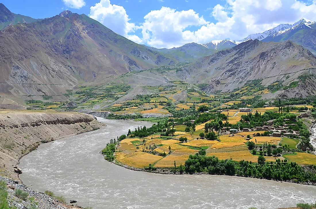
Tajikistan-Afghanistan Border
The border between Tajikistan and Afghanistan runs for approximately 810 miles, which is primarily characterized by difficult and dangerous terrain. Part of this border is made up of the Amu Darya River, which runs for a total of 1,653 miles. The Panj River is one of the tributaries to the Amu Darya and also makes up a portion of the border between Tajikistan and Afghanistan. These countries have several access points between them, the most well-known being the Tajikistan-Afghanistan Friendship Bridge, which crosses the Panj River and runs for a length of 2,205 feet. The US Army Corp of Engineers provided funding for its construction, which was finished in 2007. Both governments are concerned about their border, which has become one of the most active drug crossing areas in Central Asia.
Pakistan-Afghanistan Border
The longest border in Afghanistan, located to its southeast, is shared with Pakistan. Known as the Durand Line, this border has a length of 1,510 miles. An official agreement between the diplomat of the British Raj (which today is known as Pakistan, India, and Bangladesh) and the monarch of Afghanistan was made in November 1893. The two governments officially marked the borderline in 1894 in an effort to promote a peaceful relationship and improve the ease of trade. The Durand Line is often credited with designating Afghanistan as a type of border zone between Russian controlled areas and British controlled areas. Its position effectively separates the Pashtun tribal lands between Afghanistan and Pakistan. Today, the border is often recognized as one of the most dangerous in the world. In 2017, the government of Afghanistan reiterated its refusal to accept the Durand Line as the official border between the two countries.
China-Afghanistan Border
The shortest border in Afghanistan, located in the northeast, is shared with China. The border is located at the tip of the Wakhan Corridor, which is also known as the Afghan Panhandle, and is a piece of land that juts out from Afghanistan between Pakistan and Tajikistan, creating a 220-mile long boundary between the two countries. Its width ranges from 40 miles at its widest to 8 miles at its narrowest. The tip of the panhandle formation borders the China's Xinjiang province for a distance of 47 miles. During the 1800s, the area was treated as a buffer zone between the China's Qing dynasty, Russian forces, and British forces. China and Afghanistan do not share road access. The only mountain pass between these two countries is known as Wakhjir Pass, which was used during the Silk Trade. The government of China has decided to keep this border closed, citing civil and political instability in the Xinjiang province. Interestingly, crossing the border represents the largest time difference on land in the world, as China is 3.5 hours ahead of the time in Afghanistan.
Iran-Afghanistan Border
The border between Iran and Afghanistan is located in the western and southwestern regions of the latter country. The border is characterized by the desert and plateau environments, which seamlessly blend between the two countries. The northern section of the border is marked by the Heray River, which is also known as the Hari River. Since the region experiences an arid climate, the river often has varying levels of water. In fact, rainfall in 2010 was so scarce that the river actually experienced a dry spell. The southern section of the border, near the city of Zabol in Iran, is marked by the Helmand River, which is also known as the Helmund or Hirmand River. This river is important in Afghanistan, as it holds the distinction of being the longest in the country. Iran and Afghanistan have experienced significant political turmoil, particularly around the border region, which has led to violence in this region.


