The Nine States of Austria By Population
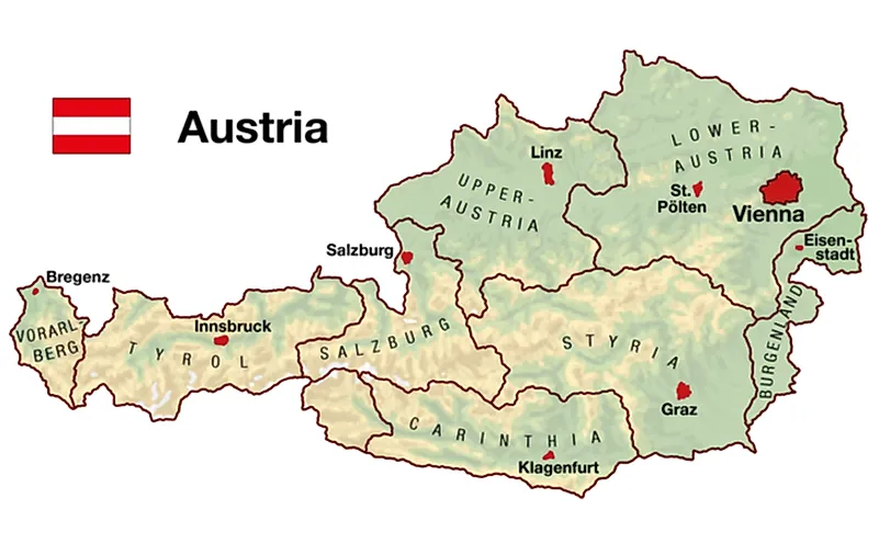
Austria is geographically and administratively divided into nine federated states locally known as “Bundeslander.” The states are further sub-divided into districts known as “Bezirke” and statutory cities. Each state has a state government and legislative authority which is distinct from the federal government. All the state governments are elected every five years except in Upper Austria which holds its election every six years. The states also have own constitution which, among other things, determines the allocation of seats among the political parties.
Austrian States By Population
1. Vienna, Both A State And Capital City
Vienna doubles as a Bundesland and the capital city of Austria. It is the largest city/state with a population of approximately 1.9 million people. The metropolitan area of Vienna has a population of about 2.6 million or one-third of the country’s population. The city-state lies in the northeastern part of Austria, in the extreme eastern part of the Alps in the Vienna Basin. It covers an area of approximately 160.1 square miles, making it Austria’s largest city both by area and population (but the smallest state). Vienna received the federal state status in 1920. It is one of the richest regions in the EU, with a GRP per capita of 47,200 euros.
2. Lower Austria, Largest Austrian State By Area
Lower Austria is the country’s largest state by area, covering 7,408 square miles. However, it is the second-largest state in Austria with a population of approximately 1.6 million people. Since 1986, St Polten has been Lower Austria’s capital city. Previously, Vienna was the state’s capital although the city has never officially been part of the state. Lower Austria is the northeasternmost state and is named after its downriver location on the Enns River. It shares its international borders with the Czech Republic and Slovakia. It also borders other Austrian states including Vienna, Upper Austria, Burgenland, and Styria.
3. Upper Austria
Upper Austria is the third most populous state in Austria with a population of approximately 1.4 million people. However, it is the fourth most extensive state with an area of about 4,626 square miles. Upper Austria shares its international borders with the Czech Republic and Germany. The state is traditionally divided into four regions and has three statutory cities with Linz as ithttps://www.worldatlas.com/articles/where-does-the-danube-river-flow.htmls capital. Upper Austria is the leading industrial region in Austria, accounting for approximately 25% of the country’s total export.
4. Styria
Styria is situated in Southeast Austria and covers an area of about 6,332 square miles, making it the second-largest state after Lower Austria. It shares its international border with Slovenia. The state has a population of approximately 1.2 million people, with some 275,000 people living in the capital Graz. Administratively, Styria is divided into 13 districts of which one (Graz) is a statutory city.
5. Tyrol
Tyrol, located in Western Austria, is the third-largest state by land area, covering approximately 4,897 square miles. The state is separated into two sections by a 4.3-mile wide strip with North Tyrol as the larger territory (the other territory is East Tyrol). With a population of about 750,000 people, the state is the 5th-largest in Austria. It forms part of the historical Princely County of Tyrol. Tyrol’s capital is Innsbruck.
Geographical Distribution Of The States
Most parts of the states of Vienna, Lower Austria, Upper Austria, and Burgenland are within the Danube Valley. The remaining five states are situated almost entirely in the Alps, making them unsuitable for agriculture and heavy industry. Thus, the population of Austria is mainly concentrated in the former four states. Although Lower Austria is the largest state by area, the majority of its land is under agriculture.
The States of Austria
| Rank | State | Population |
|---|---|---|
| 1 | Vienna (Wien) | 1,794,770 |
| 2 | Lower Austria (Niederösterreich) | 1,636,287 |
| 3 | Upper Austria (Oberösterreich) | 1,436,791 |
| 4 | Styria (Steiermark) | 1,221,014 |
| 5 | Tyrol (Tirol) | 728,537 |
| 6 | Carinthia (Kärnten) | 557,371 |
| 7 | Salzburg | 538,258 |
| 8 | Vorarlberg | 378,490 |
| 9 | Burgenland | 288,229 |


