The Most Extreme Points of Turkey
Turkey is a state that lies on two continents, Asia and Europe. A huge chunk of the nation (95%) is geographically located in Anatolia while the rest is in the Balkans. Within the country, there are several extreme points. For example, extremity according to the four cardinal points. The northernmost point is located in the border town of Kofçaz while the southernmost point is at Kale Stream’s spring at Yayladağı. The easternmost point is at Aralık, the westernmost spot is at Cape Avlaka (Gökçeada), and the center of the state is situated at a place close to the villages of Yukarıhasinli and Karakimse in Kocasinan. The highest point of Turkey is at Mount Ararat while the lowest spot is a place without a name but it is close to the Akyatan Lagoon.
7. Northernmost Point in Turkey
The northernmost point of Turkey is situated in the town and district known as Kofçaz which is in Turkey’s Marmara region in the province of Kırklareli. To be exact, the northernmost point in Turkey lies on the spot denoted by the coordinates 42°06′21″ N 27°14′27″ E which is close to the border between Turkey and Bulgaria. Aside from having the northernmost point, the region also has Turkey’s northernmost settlement in the form of the nearby settlement of Ahlatlı, some 18 miles away. The area is pretty remote as evidenced by the absence of any type of industry with the main economic activity being farming. The area has snowy winters during the cold season while the summer is denoted by high temperatures that bring about dry conditions.
6. Southernmost Point in Turkey
The southernmost point in Turkey is located within the remote district town that is known as Yayladağı which is the Hatay Province. Located in the southern region of Turkey, this remote place, which lies on the border between Syria and Turkey, is about 32 miles from the city of Antakya. Lying at the coordinates marked by 35°48′46″ N 36°09′08″ E, the spring feeding Kale Stream, which flows in the region, mark the southernmost point. Being so close to the border, the region receives plenty of refugees from the neighboring Syria. The district is mountainous and experiences a Mediterranean climate characterized by hot and dry summers with the winters being cold and a bit warm. Agriculture is the main economic activity with plants such as tobacco, olives, vegetables, and others being cultivated.
5. Westernmost Point in Turkey
This point is situated in a place known as Cape Avlaka which is located in the bigger İmbros Island, also known as Gökçeada. The westernmost point lies at the point marked by the coordinates 40°07′30″ N 25°39′56″ E. Cape Avlaka is also known as İncirburnu, İnceburun, and Avlaka Burnu. Cape Avlaka is at the doorway to the Gulf of Saros of the north Aegean Sea. The bigger region, İmbros Island, is located in the province of Çanakkale and is Turkey’s largest island. Unlike the first two extreme points, this region is advanced with a number of industries such as tourism as well as a higher population. The climate is Mediterranean characterized by warm, dry summers and wet, cool winters. Lying close to the North Anatolian Fault, the island has been a recipient of some deadly earthquakes in the past.
4. Easternmost Point in Turkey
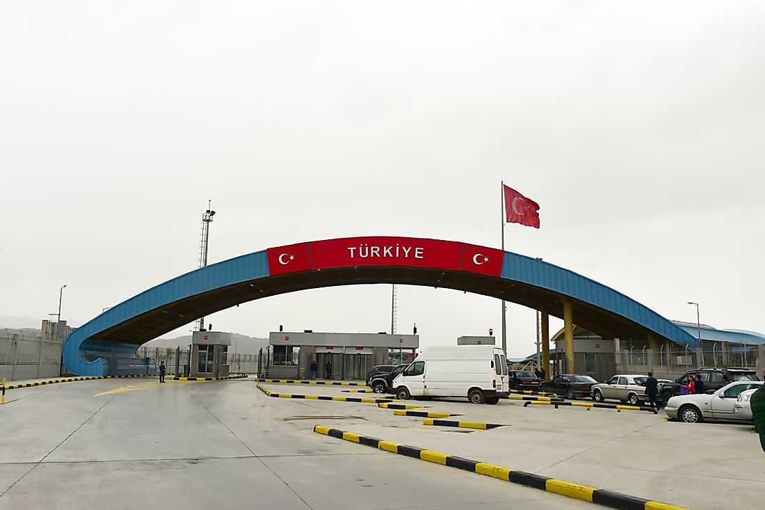
The easternmost spot in Turkey is located in the region of Aralık which is a district and town in the province of Iğdır. The region is in the Eastern Anatolia area of Turkey and has a corridor known as the Aras corridor which serves as a link between Turkey and Azerbaijan. Around the Dilucu Bordergate, in a spot marked by the coordinates 39°39′03″ N 44°49′04″ E, is the easternmost point. The Dilucu Bordergate serves as the connection between Turkey and the Nakhchivan Autonomous Republic which then provides access to Azerbaijan. The town also has two other borders that are currently closed; between Turkey and Iran and between Turkey and Armenia. Despite being in Turkey, a larger percentage of the population is actually from Azerbaijan.
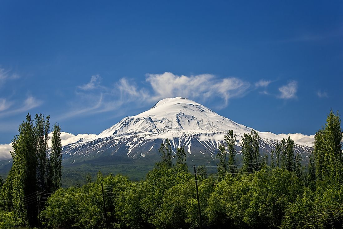
3. Highest Point in Turkey
The highest point in Turkey is situated at Mount Ararat which lies on the area denoted by the coordinates 39°42.113′ N 44°17.899′ E. The mountain is a dormant compound volcano with snow on the cap. There are two volcanic cones on the mountain namely the Greater Ararat and Little Ararat. The Greater Ararat is the highest peak with a height of 16,854 feet while Little Ararat has about 12,782 feet. An interesting thing about this mountain is that a huge number of Christians accept that Noah’s Ark is resting in the mountain. For Armenians, the mountain is the national symbol and is considered to be sacred. In fact, Armenians have the mountain and Noah’s Ark on the nation’s coat of arms. The first time the mountain was recorded as climbed was back in 1829.
2. Lowest Point in Turkey
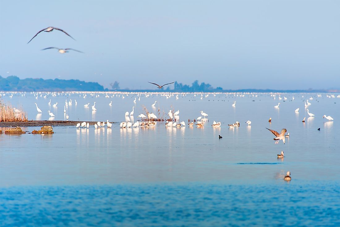
This point is currently unnamed but it is close to the Akyatan Lagoon which is the Mediterranean Sea close to the larger region of Adana. The coordinates for the unnamed place are somewhere close to 36°37′00″ N 35°16′00″ E. The height of the place is −9.2 feet. The larger area of the lagoon, which is designated as a wetland, is situated in the region of Çukurova while the lagoon itself can be entered from Küçük Karataş Village or Tuzla. The lagoon is known for its massive green turtle rookery which hosts about 43% of the Mediterranean nesting populace. In addition, the lagoon is a popular stop-over for migratory birds and has been classified as an important area for birds. Human activities in and around the wetland include agriculture and livestock, recreation and tourism, and fishing and hunting.
1. Geographic Center of Turkey
Determining the geographical center of a nation is not an easy task. However, based on the rectangular shapes formed by the meridians passing through the other extreme points in Turkey, the estimated center of Turkey is at a spot close to the villages of Yukarıhasinli and Karakimse. The point denoted by the coordinates 38°57′32″ N 35°11′12″ E. This point is close to the metropolitan district of Kocasinan in the Central Anatolia area of Turkey. Interestingly, Google recently marked another spot in Turkey as the geographical center of the globe.


