Largest Islands In Saint Vincent And The Grenadines
Almost 90% of the archipelagic nation's entire land area is comprised by the island of Saint Vincent. A chain of small islands stretches to the north to meet the Grenadine, which in turn extends southwards to Grenada. St Vincent lies 20 miles southwest of Saint Lucia and 100 miles west of Barbados. The island is 18 miles long and 11 miles wide with a population density of 300 inhabitants per square kilometer. The islands of Bequia, Mayreau, Prune, Canouan, Union and Petit Saint Vincent are Grenadines associated with Saint Vincent. Kingstown on the mainland of St Vincent Island is the major and capital city of the country.
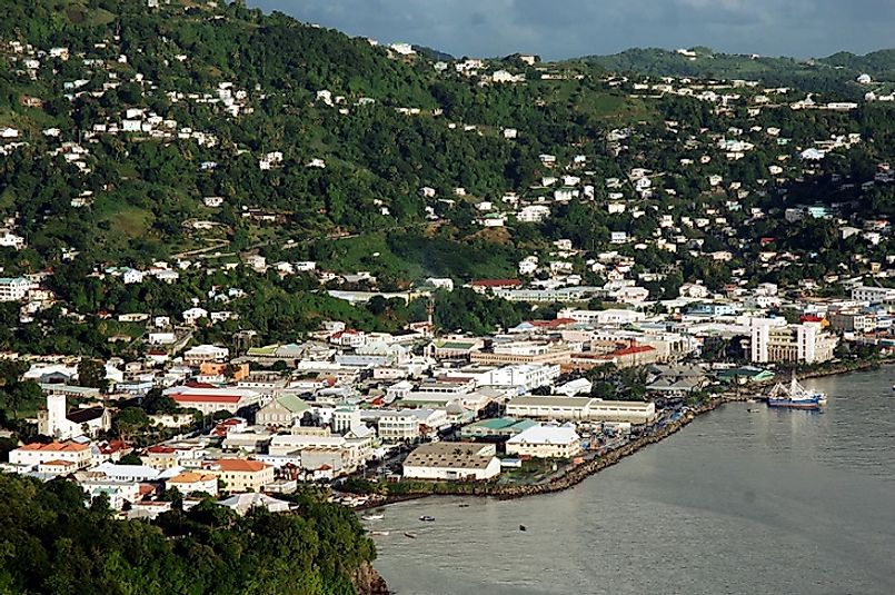
Saint Vincent
It is the main island covering 133 square miles. Saint Vincent is a volcanic island with its topography being mountainous. The windward side receives rain and is rocky and steep while the leeward side has many sandy beaches and bays. Kingstown, the capital and Major economic center of the Island is located in mainland Saint Vincent. The island experiences tropical maritime climate, and the northeast trade winds pass through it. Also, tropical cyclones occasionally pass near or across the island. In the 18 and 19th Centuries, the island suffered severe hurricanes. The small hurricanes of 1955 and 1980 were not severe.
Bequia
Bequia Island is the second largest island of Saint Vincent with 7 square miles of land area. It is a green and hilly outpost of the Grenadines lying 9 miles south of St Vincent. The name Bequia comes from the ancient Arawak meaning island of the clouds. It has a population of approximately 4,300. The native population is a mixture of Africans, Caribs, and Scottish descent. The capital, Port Elizabeth, and Mount Pleasant are the most populated areas of the island. Prominent areas include spring a former coconut plantation and ranch, and Park Bay where the Old Hegg Turtle Sanctuary is located. Easter Regatta is the busiest time of the year. The island is famous for its cruising yachts and expats. Scuba diving is a major sport, and the island provides wrecks and shallow caves for experienced divers. The Hawksbill turtles, moral eels, and lobsters are common species in Bequia.
Union Island
The island has an area of around 3 square miles, and lies 200 kilometers southwest of Barbados. The mainland of Grenada lies to the south of the Union Island. The islands of Palm, Tobago Cays, and Mayreau surround it. The island experience as semi-arid climate and stored water is the only source of water in the dry months of January-June. Union Island has a population of around 3,000 residents with Clifton and Ashton being the major towns. Similar to the rest of Saint Vincent, English is the official language, but merchants in the region speak French and German. The Arawak and Caribs are the original settlers, but the French and English slave traders colonized the island. Africans from Nigeria, Ghana, Angola, and Cameroon provided labor in the plantations especially the Sea Island Cotton. The opossum, bananaquit Caribbean birds, and the ubiquitous black bird are the dominant fauna species. Yachts on their way to Tobago Cays are the primary form of tourism on the island. The Turtle Watch is major tourist attraction taking place in March through July. The local bars and restaurants offer tradition delicacies and flavors also attract tourist. Since most of the people are Protestants Easter is a big event on the island.
Canouan
The island lies approximately 25 miles south of St. Vincent with an area of 3 square miles. It has a small population of around 1,700 people. Mount Royal is the highest point on the island, and a barrier relief lies on the Atlantic side. The Arawaks settled on the island before 2000 B.C. and brought animals, plants, and farming and fishing skills. The Caribs invaded the island and took over, but 200 years later Columbus established settlements in the island after defeating the Caribs. The French colonized the island and brought slaves to work in the plantations. Colonial wars followed with Britain and France fighting over the island until the British defeated the French in 1814. As a result, the population is a fusion of African, French, British, and Carib cultures. The primary tourist destination is the prestigious Golf Course designed by Jim Fazio which offers Private villas and restaurants.
Socioeconomic Landscape
Agriculture, and more specifically banana production, is the most important economic activity in the country. Tourism is the second biggest service center of the St Vincent and the Grenadines. The country depends on a single crop, and tropical storms are the most major threats. English is the formal language used in education, religion, government and other structured setups. The country has a population of around 103,220 with 66% having African descent, 19% mixed, 6% East Indian, and 4% European.
| Rank | Major Islands of Saint Vincent and the Grenadines | Land Area |
|---|---|---|
| 1 | Saint Vincent | 133 square miles |
| 2 | Bequia | 7 square miles |
| 3 | Union | 3 square miles |
| 4 | Canouan | 3 square miles |
| 5 | Mustique | 2.2 square miles |
| 6 | Mayreau | 1.5 square miles |
| 7 | Palm | 0.2 square miles |
| 8 | Petit Saint Vincent | 0.2 square miles |


