How Far is Russia From Alaska?
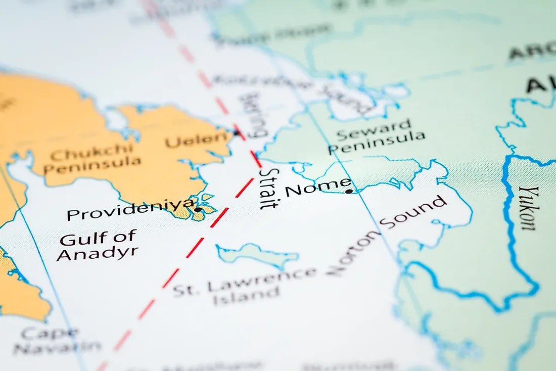
Russia and Alaska are separated by the Bering Strait. At the narrowest point, the Bering Strait measures approximately 55 miles. Nevertheless, in the middle of the Strait, there are two Islands. The Islands are the Big Diomede in the Russian Territory and the Little Diomede Island administered by the United States. The distance between the two Islands is just 3 miles (4.8 kilometers). The Islands shorten the distance between Russia and Alaska.
Russia
Russia, the largest country in the world, is located in Eastern Europe and North Asia. The Eurasian continent extends towards the Pacific Ocean. Covering almost 6.6 million square miles, Russia extends towards Alaska on the eastern side in the Kamchatka Krai region. The Kamchatka Peninsula borders the Ocean and is the nearest point to Alaska. The zone is characterized by mountains, tundra, cliffs, and forests. Numerous volcanic ranges manifest in the region. The Commander Islands and Karaginsky are found on this edge of Russia.
Alaska
Alaska is a State in the United States of America in the North America Continent. Although it is the largest state by land size, Alaska is among the least populated states. Located in the extreme northwest of the continent, the State has a maritime border with Russia towards the western side. The Pacific Ocean spreads in the south and southwest side. The Aleutian Islands ensures that Alaska has the largest share of the easterly longitude among the US’ states because the Islands extend to the Eastern Hemisphere. Territorial waters of Alaska touch those of Russia in the Bering Strait. Alaska covers an area of 663,268 square miles. It has the longest coastline compared to other State with many Volcano Islands that stretches over 1,200 miles into the Pacific Ocean towards Russia.
The Bering Strait Crossing
Hypothetically speaking, there is a bridge that one can use to move from Russia to Alaska. The hypothetical bridge across Bering Strait crossing and a tunnel across the Diomede Islands would give an opportune link between Russia and Alaska. The connecting points from Russia are the Chukotka Peninsula which would link to the Seward Peninsula in Alaska. That way, there would be a single bridge measuring about 40 kilometers (25 miles) from Alaska to Diomede Islands. From the Islands, a tunnel will be constructed connecting the Diomede Islands to Russia. The two Islands can be connected using the earth removed from the tunnels.
Traveling between Russia and Alaska
By air, the distance between the nearest airports of Russia and Alaska is almost 2,949 miles. This translates to 5.27 hours journey if the airplane is traveling at a speed of 560 miles per hour. One traveling from Vladivostok to Provideniya can charter a plane to Nome in Alaska.
Is It Possible to Swim From Russia to Alaska?
Daring swimmers have made it across the ocean. Philippe Croizon, a quadruple amputee and a French athlete, managed to swim from Alaska to Russia in approximately 80 minutes.
If governments from both sides agree to build infrastructures and provide necessary resources, the movement between Russia and Alaska would be made fast. The bridge or tunnel will make the movement of goods and people easier and faster. However, as it is now, movement between the two countries is not seamless.


