
How Many Countries Are There In The World?
While it may seem straightforward, defining the number of countries in the world can be a complex issue depending on varying levels of international recognition. Here at Worldatlas.com, we state that there are 195 countries based on the 193 that belong to the United Nations (UN) plus the Holy See (Vatican) and the State of Palestine, which are non-member observer states. However, only 145 of the 193 United Nations member states recognize the State of Palestine. Currently, there are 23 countries in North America, 12 in South America, 44 in Europe, 54 in Africa, 48 in Asia, and 14 in Australia/Oceania.
Differing Opinions
The United States officially recognizes 195 countries as well; but instead of recognizing the State of Palestine, it recognizes Kosovo. Only 97 out of the 193 United Nations member states recognize Kosovo. In particular, Spain is one of the biggest opponents due to its opposition to the Basque and Catalan independence movements within its own country.
Sources do not always agree on the total number of countries in the world. Other sources claim there are 197 countries. They count the Holy See and Palestine as UN observers but also consider Taiwan and Kosovo to be self-governed territories that both have substantial economic resources of their own.
The latter fact is because Taiwan is considered part of the Chinese territory; the same is true for Kosovo being part of Serbia. With all the socio-economic, geographical, and political difficulties, this can all be subject to change over time.
Generally, the UN seems to be a reliable source for the total number of countries. For a country to be a part of this organization, the country must apply for membership, be assessed, and then be voted in. The country has to be approved by the five permanent member countries: China, France, Russia, the United Kingdom, and the United States).
- Official Country List
- Is Kosovo a Country?
- Is Taiwan a Country?
- United Kingdom's Constituent Countries
- Disputed Countries and Territories
- Semi-Autonomous Regions
- Dependent Territories
- The Future
Is Kosovo a Country?

Recognizing Kosovo as an independent country has been a contentious issue in international politics for many years. While the United States has recognized Kosovo as a sovereign state since it declared independence from Serbia in 2008, other countries and international bodies do not.
One reason why the US recognizes Kosovo is its close relationship with the Kosovar Albanians, who make up most of the population in Kosovo. During the 1990s, Serbia - then part of Yugoslavia - waged a brutal campaign against ethnic Albanians in Kosovo, leading to NATO military intervention in 1999. The US played a crucial role in this intervention and subsequently supported efforts to establish an independent Kosovo.
However, other countries, such as Russia and China, have opposed Kosovo's independence due to concerns about separatist movements within their borders. In addition, some argue that recognizing Kosovo sets a dangerous precedent for other regions seeking freedom from their parent countries.
International bodies such as the United Nations have also struggled with the issue of recognizing Kosovo. While some member states recognize it as an independent country, others do not - including Russia and China, which hold veto power on the UN Security Council.
Is Taiwan a Country?

The issue of Taiwan's status as a sovereign state is a complex and controversial topic that has persisted for decades. While some countries, such as the United States, recognize Taiwan as independent, others do not. One of the main reasons for this discrepancy is China's position on the matter.
China considers Taiwan a part of its territory and rejects any notion of Taiwanese independence. As one of the world's largest and most influential countries, China wields significant political and economic power, which can influence other nations' decisions regarding Taiwan's status. Many countries have chosen to adhere to China's "One China" policy, which recognizes Taiwan as a part of China rather than an independent country.
On the other hand, some countries believe that Taiwan's unique culture, government, and economy distinguish it from mainland China. These countries argue that Taiwan is worthy of recognition as a fully independent nation with equal rights in international affairs.
In addition to political considerations, there are also economic factors at play. For example, many countries maintain close trade relationships with China and Taiwan. Recognizing one over the other could harm economic ties with either nation - and given the importance of Taiwan's production of microchips, it is a precarious situation.
United Kingdom and the constituent countries of England, Scotland Wales and Northern Ireland.
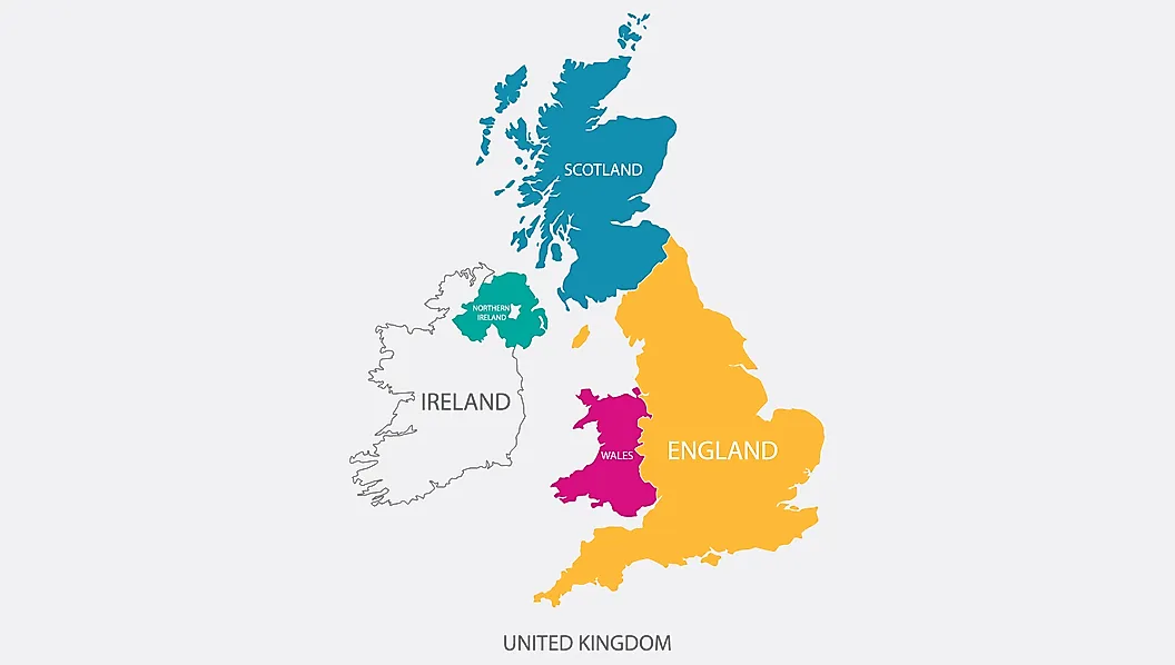
Countries within the United Kingdom, such as England, Scotland, Wales, and Northern Ireland, are often referred to as constituent countries. However, legally, they are considered administrative levels rather than sovereign states. This means they do not have complete autonomy or separate international recognition. A similar situation can be found in other parts of the world. For instance, the Netherlands has constituent countries like Aruba, Curaçao, and Sint Maarten; Russia has administrative territories like Adygea; and Denmark has constituent countries like Greenland and the Faroe Islands. These territories hold varying levels of autonomy, but none are fully sovereign.
Therefore, England, Scotland, Wales, and Northern Ireland, are not independent because they are part of the United Kingdom. In Scotland while some Scots want to maintain the status quo, others favor splitting from the UK and becoming independent. Governing administrations held a referendum in 2014 to decide whether Scotland should become independent or remain part of the UK. However, despite an impassioned campaign by independence supporters, the vote did not pass, and Scotland remained within the UK.
More recently, the Brexit vote has further complicated matters for Scotland. In the 2016 referendum on whether Britain should leave the European Union (EU), Scottish voters overwhelmingly chose to remain - with 62 percent voting against Brexit. Despite these divisions, Scotland remains part of the United Kingdom for now. Whether it will someday become an independent country or continue as part of a larger union remains to be seen. Given the unique history and shared culture that the Scottish have diligently fought to maintain, it is likely that this issue will be debated for years.
Why the Hesitation?
There are various reasons why some countries refuse to acknowledge other countries as territories, which affects the total count. In the case of Spain, for example, it does not recognize Kosovo as an independent state because doing so could legitimize independence movements within Spain itself. This reluctance, also shared by Russia and China, highlights how political and strategic self-interests can play a significant role in determining whether or not a country recognizes another's territorial claims. Interestingly, the United States recognizes Kosovo but not Taiwan, despite the similarity of their situations.
Another factor that affects recognition is the United Nations (UN) approval. The UN requires that new members be approved unanimously by its five permanent member countries: China, Russia, France, the United Kingdom, and the United States. As China does not favor Taiwan's independence, the UN does not officially recognize Taiwan as a sovereign state.
Disputed Countries and Territories
Various territorial conflicts around the world demand attention. These disputes often complicate the question of how many countries exist globally.
In the Israel/Palestine region, two groups lay claim to the same land. Israelis, primarily Jews, and Palestinians, mostly Muslim Arabs, have engaged in a long-lasting conflict over territory, resources, and political control. Both parties assert their right to statehood, resulting in an ongoing dispute.
Jammu & Kashmir present another contentious area, with India, Pakistan, and China all vying for control. Historically a princely state, Jammu & Kashmir acceded to India in 1947, but Pakistan and China also claim parts of the territory. The region has witnessed armed conflict, political upheaval, and human rights violations, fueling animosity between the countries involved.
Western Sahara, a sparsely populated region in northwest Africa, has been the focus of a dispute between Morocco and the Sahrawi Arab Democratic Republic (SADR). The conflict originated when Spain, Western Sahara's former colonial ruler, withdrew in 1975. Morocco, Mauritania, and the indigenous Sahrawi people all sought control of the territory. Mauritania later relinquished its claim, but Morocco and the SADR, backed by the Polisario Front, continue to struggle for dominance.
Antarctica, the Earth's southernmost continent, has multiple countries asserting territorial claims. However, the Antarctic Treaty System, signed in 1959, prevents new claims and discourages military activity, enabling scientific cooperation and environmental protection. Nevertheless, territorial disputes occasionally resurface, adding uncertainty to the region's future.
The Kuril Islands, an archipelago in the North Pacific, lie at the center of a dispute between Russia and Japan. Russia administers the islands, but Japan claims sovereignty over four southernmost islands. The disagreement has prevented the two countries from signing a peace treaty to formally end World War II hostilities.
Crimea, a Eastern European peninsula, has witnessed a territorial dispute between Ukraine and Russia since 2014. Russia forcibly annexed Crimea, triggering a crisis that led to ongoing military conflict and political tensions. The international community widely condemns the annexation, but Russia maintains control of the territory.
The Korean Peninsula comprises two countries, North Korea and South Korea, which remain technically at war since the Korean War armistice in 1953. The heavily fortified border, the Korean Demilitarized Zone, separates the nations. Despite sporadic attempts at diplomacy, reunification remains a distant prospect.
Semi-Autonomous Regions
These territories, also known as de facto states or unrecognized countries, declare independence and exercise some degree of self-governance, but lack widespread international recognition. This article will examine six such breakaway states: Transnistria, Artsakh, South Ossetia, Abkhazia, Sahrawi Arab Democratic Republic, and Somaliland.
Transnistria, officially known as the Pridnestrovian Moldavian Republic, emerged in 1990 after declaring independence from Moldova. This narrow strip of land, situated between the Dniester River and the Ukrainian border, maintains its own government, military, and police force. Although Transnistria remains unrecognized by the international community, Russia provides it with significant financial and military support.
Artsakh, formerly known as Nagorno-Karabakh, declared its independence from Azerbaijan in 1991. A predominantly ethnic Armenian region, Artsakh experienced a bloody war with Azerbaijan from 1988 to 1994, and sporadic fighting continued in the following decades. Despite the region's self-proclaimed independence, it remains internationally recognized as part of Azerbaijan. While Armenia supports Artsakh politically and militarily, it has not formally recognized the region's independence.
South Ossetia and Abkhazia are both breakaway regions located in the South Caucasus. South Ossetia declared its independence from Georgia in 1990 (more specifically, South Ossetia stated its interest in joining with Russia, but only achieved independence in 2008), while Abkhazia followed suit in 1992. Both regions experienced violent conflicts with Georgia in the 1990s and during the 2008 Russo-Georgian War. In the aftermath of the 2008 war, Russia recognized the independence of South Ossetia and Abkhazia, and they remain heavily dependent on Russian financial and military support. The international community, however, largely recognizes these territories as part of Georgia.
The Sahrawi Arab Democratic Republic (SADR) proclaimed its independence in 1976, after Spain withdrew from Western Sahara. SADR claims sovereignty over the entire territory of Western Sahara, although Morocco controls roughly 80% of the region. The SADR's government operates from refugee camps in Tindouf, Algeria, while the Polisario Front, its military wing, engages in a protracted conflict with Morocco. Although some countries recognize the SADR, the United Nations still considers Western Sahara a non-self-governing territory.
Lastly, Somaliland declared its independence from Somalia in 1991, following a brutal civil war and the collapse of the Somali central government. This self-proclaimed state in the Horn of Africa maintains a functioning government, holds regular elections, and provides social services to its citizens. Despite its relative stability compared to the rest of Somalia, Somaliland remains unrecognized by the international community, which continues to consider it an autonomous region within Somalia.
Dependent Territories
Approximately 58 dependent territories can be found across the globe. While not independent, these territories preserve their unique cultural and political identities. Four notable territories have been selected as illustrative examples, embodying the common traits, historical contexts, and dependence on larger nations shared by the other 54.
American Samoa, an unincorporated territory of the United States, lies in the South Pacific. The US acquired American Samoa through the 1899 Tripartite Convention, which divided the Samoan archipelago between the US and Germany. As a dependent territory, the US handles its defense and foreign affairs. American Samoa possesses a unique culture, with strong ties to traditional Samoan customs and its distinct language, Samoan. Despite their US affiliation, American Samoans are considered US nationals, not US citizens, granting them fewer rights than citizens living in the 50 states.
Bermuda, a British Overseas Territory in the North Atlantic Ocean, boasts a rich history dating back to its accidental discovery in 1505. The English claimed the island in 1609 after the shipwreck of the Sea Venture, which led to the establishment of a colony. Bermuda functions as a self-governing territory with its parliament and constitution, but the UK remains responsible for defense and foreign affairs. Bermuda's economy relies heavily on tourism and offshore financial services, while its subtropical climate and pink-sand beaches make it a popular vacation destination.
Gibraltar, a British Overseas Territory located at the southern tip of the Iberian Peninsula, has a long and contested history. Captured by an Anglo-Dutch force in 1704 during the War of the Spanish Succession, Gibraltar was ceded to Britain under the 1713 Treaty of Utrecht. Spain continues to claim sovereignty over the territory. Gibraltar enjoys a high degree of autonomy, with its parliament handling domestic affairs, but the UK manages defense and foreign relations. The iconic Rock of Gibraltar and its strategic location have granted it significant military and commercial importance.
French Polynesia, an overseas collectivity of France, comprises 118 islands in the South Pacific. The French established a protectorate over the region in the 19th century, and it became an overseas territory in 1946. In 2004, French Polynesia gained more autonomy, adopting its current status as an overseas collectivity. France retains control over defense, foreign affairs, and law enforcement. Known for its picturesque landscapes and vibrant marine life, French Polynesia has developed a thriving tourism industry.
List Of Dependent Territories Around The World
| Dependency/Territory | Capital | Claimed By |
|---|---|---|
|
American Samoa |
Pago Pago |
USA |
|
Anguilla |
The Valley |
UK |
|
Aruba |
Oranjestad |
Netherlands |
|
Ashmore & Cartier Islands |
NA |
Australia |
|
Baker & Howland Islands |
NA |
USA |
|
Bermuda |
Hamilton |
UK |
|
Bouvet Island |
NA |
Norway |
|
British Indian Ocean Territory |
Diego Garcia |
UK |
|
British Virgin Islands |
Road Town |
UK |
|
Cayman Islands |
George Town |
UK |
|
Christmas Island |
Flying Fish Cove |
Australia |
|
Cocos Islands |
West Island |
Australia |
|
Cook Islands |
Avarua |
New Zealand |
|
Coral Sea Islands |
NA |
Australia |
|
Faeroe Islands |
Torshavn |
Denmark |
|
Falkland Islands |
Stanley |
UK |
|
French Guiana |
Cayenne |
France |
|
French Polynesia |
Papeete |
France |
|
Gibraltar |
Gibraltar |
UK |
|
Greenland |
Nuuk |
Denmark |
|
Guadeloupe |
Basse-Terre |
France |
|
Guam |
Agana |
USA |
|
Guernsey |
St. Peter Port |
UK |
|
Heard & Mc Donald Islands |
NA |
Australia |
|
Hong Kong |
NA |
Controlled by China |
|
Isle of Man |
Douglas |
UK |
|
Jan Mayen |
NA |
Norway |
|
Jarvis Island |
NA |
USA |
|
Jersey |
St. Helier |
UK |
|
Johnston Atoll |
NA |
USA |
|
Kingman Reef |
NA |
USA |
|
Macao |
Macao |
Controlled by China |
|
Martinique |
Fort-de-France |
France |
|
Mayotte |
Mamoudzou |
France |
|
Midway Islands |
NA |
USA |
|
Monteserrat |
Plymouth |
UK |
|
Navassa Island |
NA |
USA |
|
Netherlands Antilles |
Willemstad |
Netherlands |
|
New Caledonia |
Noumea |
France |
|
Niue |
Alofi |
New Zealand |
|
Norfolk Island |
Kingston |
Australia |
|
Northern Mariana Islands |
Saipan |
USA |
|
Palmyra Atoll |
NA |
USA |
|
Paracel Islands |
Woody Island |
disputed by China, Taiwan and Vietnam |
|
Puerto Rico |
San Juan |
USA |
|
Peter Island |
NA |
Norway |
|
Pitcairn Islands |
Adamstown |
UK |
|
Reunion |
Saint-Denis |
France |
|
St. Helena & Dependencies |
Jamestown |
UK |
|
St. Pierre & Miquelon |
St. Pierre |
France |
|
South Georgia & South Sandwich Islands |
Grytviken |
UK |
|
Spratly Islands |
NA |
disputed by China, Vietnam, Malaysia and more |
|
Svlabard |
Longyearbyen |
Norway |
|
Tokelau |
NA |
New Zealand |
|
Turks & Caicos Islands |
Cockburn Town |
UK |
|
Virgin Islands |
Charlotte Amalie |
USA |
|
Wake Island |
NA |
USA |
|
Wallis & Futuna |
Mata Uta |
France |
Complicating Things
The constant flux of politics and globalization are continually redefining countries, so agreeing on a final count can be difficult. In addition to the reasons already described, here are some additional facts.
- Switzerland did not join the UN until 2002 and was a sovereign state before they came on board.
- The United Kingdom plays a substantial part on the global economic front and is a permanent UN Security Council member. Even so, the United Kingdom includes England, Northern Ireland, Scotland, and Wales. All four have complicated political histories - including territorial disputes. These are ongoing to this very day.
- Greenland, on its own, is not a UN member country and operates much of its domestic affairs. However, it is controlled by Denmark, which is thousands of miles away in Europe. Denmark is also a lot smaller than Greenland!
- Niue and The Cook Islands are not UN member states. They are both in free association with New Zealand. New Zealand is "members of "several UN specialized agencies." They are recognized as "full treaty-making capacity."
- Bhutan does not recognize China as a country, more specifically, the PRC and the ROC.
The Future
Some researchers believe that there could be even more countries in the future. One of these is East & West Libya. This is because Libya has often been in turmoil, because of extremists there fighting for control and different governments trying to take over since Gaddafi was overthrown. Based in Barcelona, Spain, Catalonia is the country's financial center. Catalans have wanted a separate state for many years, although many are opposed to separation.
Somaliland (part of Somalia) considers itself independent and has its own government, army, and currency. It had self-proclaimed independence and has informal ties with other countries. Formal recognition from the rest of the world is yet to come, though.
Official Country List
| Countries | Population 2024 | Land Area Km² | Density (P/Km²) |
|---|---|---|---|
| Afghanistan | 35,581,000 | 652,230.2 | 54.6 |
| Albania | 2,715,000 | 28,748.0 | 94.4 |
| Algeria | 46,839,000 | 2,381,740.8 | 19.7 |
| Andorra | 86,600 | 468.0 | 185.0 |
| Angola | 35,159,000 | 1,246,700.4 | 28.2 |
| Antigua and Barbuda | 103,600 | 443.0 | 233.9 |
| Argentina | 47,225,000 | 2,780,400.9 | 17.0 |
| Armenia | 3,009,000 | 29,743.0 | 101.2 |
| Australia | 27,307,000 | 7,741,222.5 | 3.5 |
| Austria | 9,295,000 | 83,871.0 | 110.8 |
| Azerbaijan | 10,210,000 | 86,600.0 | 117.9 |
| Bahamas | 409,000 | 13,880.0 | 29.5 |
| Bahrain | 1,603,000 | 760.0 | 2109.2 |
| Bangladesh | 168,120,000 | 148,460.0 | 1132.4 |
| Barbados | 263,700 | 430.0 | 613.3 |
| Belarus | 9,119,000 | 207,600.1 | 43.9 |
| Belgium | 11,870,000 | 30,528.0 | 388.8 |
| Belize | 465,000 | 22,966.0 | 20.2 |
| Benin | 13,844,000 | 112,622.0 | 122.9 |
| Bhutan | 777,200 | 38,394.0 | 20.2 |
| Bolivia | 12,341,000 | 1,098,581.4 | 11.2 |
| Bosnia and Herzegovina | 3,393,000 | 51,197.0 | 66.3 |
| Botswana | 2,413,000 | 581,730.2 | 4.1 |
| Brazil | 205,223,000 | 8,515,772.7 | 24.1 |
| Brunei | 455,400 | 5,765.0 | 79.0 |
| Bulgaria | 6,366,000 | 110,879.0 | 57.4 |
| Burkina Faso | 23,409,000 | 274,200.1 | 85.4 |
| Burundi | 13,439,000 | 27,830.0 | 482.9 |
| Cote d'Ivoire | 32,065,000 | 322,463.1 | 99.4 |
| Cabo Verde | 491,100 | 4,033.0 | 121.8 |
| Cambodia | 16,719,000 | 181,035.1 | 92.4 |
| Cameroon | 27,334,000 | 475,440.2 | 57.5 |
| Canada | 42,069,000 | 9,984,673.2 | 4.2 |
| Central African Republic | 5,651,000 | 622,984.2 | 9.1 |
| Chad | 19,094,000 | 1,284,000.4 | 14.9 |
| Chile | 20,095,000 | 756,102.2 | 26.6 |
| China | 1,410,474,000 | 9,596,963.1 | 147.0 |
| Colombia | 52,848,000 | 1,138,910.4 | 46.4 |
| Comoros | 860,600 | 2,235.0 | 385.1 |
| Congo (Congo-Brazzaville) | 6,373,000 | 342,000.1 | 18.6 |
| Costa Rica | 5,191,000 | 51,100.0 | 101.6 |
| Croatia | 3,696,000 | 56,594.0 | 65.3 |
| Cuba | 11,054,000 | 110,860.0 | 99.7 |
| Cyprus | 1,336,000 | 9,251.0 | 144.4 |
| Czechia (Czech Republic) | 11,235,000 | 78,867.0 | 142.5 |
| Democratic Republic of the Congo | 115,403,000 | 2,344,858.7 | 49.2 |
| Denmark | 5,989,000 | 43,094.0 | 139.0 |
| Djibouti | 1,052,000 | 23,200.0 | 45.3 |
| Dominica | 63,200 | 751.0 | 84.2 |
| Dominican Republic | 10,954,000 | 48,670.0 | 225.1 |
| Ecuador | 17,340,000 | 283,561.1 | 61.2 |
| Egypt | 106,647,000 | 1,001,450.3 | 106.5 |
| El Salvador | 6,351,000 | 21,041.0 | 301.8 |
| Equatorial Guinea | 1,669,000 | 28,051.0 | 59.5 |
| Eritrea | 6,344,000 | 117,600.0 | 53.9 |
| Estonia | 1,418,000 | 45,228.0 | 31.4 |
| Eswatini (fmr. "Swaziland") | 1,206,000 | 17,364.0 | 69.5 |
| Ethiopia | 109,900,000 | 1,104,300.4 | 99.5 |
| Fiji | 900,300 | 18,274.0 | 49.3 |
| Finland | 5,625,000 | 338,145.1 | 16.6 |
| France | 66,147,000 | 643,801.2 | 102.7 |
| Gabon | 2,430,000 | 267,667.1 | 9.1 |
| Gambia | 3,041,000 | 11,300.0 | 269.1 |
| Georgia | 3,809,000 | 69,700.0 | 54.6 |
| Germany | 86,303,000 | 357,022.1 | 241.7 |
| Ghana | 32,823,000 | 238,533.1 | 137.6 |
| Greece | 9,456,000 | 131,957.0 | 71.7 |
| Grenada | 116,400 | 344.0 | 338.4 |
| Guatemala | 16,564,000 | 108,889.0 | 152.1 |
| Guinea | 13,990,000 | 245,857.1 | 56.9 |
| Guinea-Bissau | 1,663,000 | 36,125.0 | 46.0 |
| Guyana | 741,300 | 214,969.1 | 3.4 |
| Haiti | 12,436,000 | 27,750.0 | 448.1 |
| Holy See | 453 | 0.4 | 1029.5 |
| Honduras | 9,895,000 | 112,090.0 | 88.3 |
| Hungary | 9,574,000 | 93,028.0 | 102.9 |
| Iceland | 403,000 | 103,000.0 | 3.9 |
| India | 1,384,380,000 | 3,287,264.0 | 421.1 |
| Indonesia | 282,154,000 | 1,904,375.6 | 148.2 |
| Iran | 87,529,000 | 1,648,195.5 | 53.1 |
| Iraq | 44,528,000 | 438,317.1 | 101.6 |
| Ireland | 5,304,000 | 70,273.0 | 75.5 |
| Israel | 9,177,000 | 21,937.0 | 418.3 |
| Italy | 58,653,000 | 301,340.1 | 194.6 |
| Jamaica | 2,753,000 | 10,991.0 | 250.5 |
| Japan | 123,953,000 | 377,915.1 | 328.0 |
| Jordan | 11,680,000 | 89,342.0 | 130.7 |
| Kazakhstan | 20,485,000 | 2,724,900.9 | 7.5 |
| Kenya | 51,563,000 | 580,387.2 | 88.8 |
| Kiribati | 126,700 | 811.0 | 156.2 |
| Kuwait | 5,184,000 | 17,818.0 | 290.9 |
| Kyrgyzstan | 7,254,000 | 199,951.1 | 36.3 |
| Laos | 7,658,000 | 236,800.1 | 32.3 |
| Latvia | 1,875,000 | 64,589.0 | 29.0 |
| Lebanon | 7,447,000 | 10,400.0 | 716.1 |
| Lesotho | 2,120,000 | 30,355.0 | 69.8 |
| Liberia | 5,498,000 | 111,369.0 | 49.4 |
| Libya | 7,820,000 | 1,759,540.6 | 4.4 |
| Liechtenstein | 39,900 | 160.0 | 249.4 |
| Lithuania | 2,882,000 | 65,300.0 | 44.1 |
| Luxembourg | 683,500 | 2,586.0 | 264.3 |
| Madagascar | 30,854,000 | 587,041.2 | 52.6 |
| Malawi | 20,271,000 | 118,484.0 | 171.1 |
| Malaysia | 33,173,000 | 329,847.1 | 100.6 |
| Maldives | 544,700 | 298.0 | 1827.9 |
| Mali | 23,948,000 | 1,240,192.4 | 19.3 |
| Malta | 550,100 | 316.0 | 1740.8 |
| Marshall Islands | 39,700 | 181.0 | 219.3 |
| Mauritania | 4,582,000 | 1,030,700.3 | 4.4 |
| Mauritius | 1,235,000 | 2,040.0 | 605.4 |
| Mexico | 132,529,000 | 1,964,375.6 | 67.5 |
| Micronesia | 105,400 | 702.0 | 150.1 |
| Moldova | 2,487,000 | 33,851.0 | 73.5 |
| Monaco | 39,600 | 2.0 | 19800.0 |
| Mongolia | 3,530,000 | 1,564,116.5 | 2.3 |
| Montenegro | 615,200 | 13,812.0 | 44.5 |
| Morocco | 36,769,000 | 716,550.2 | 51.3 |
| Mozambique | 36,769,000 | 799,380.3 | 46.0 |
| Myanmar (formerly Burma) | 57,333,000 | 676,578.2 | 84.7 |
| Namibia | 2,688,000 | 824,292.3 | 3.3 |
| Nauru | 12,100 | 21.0 | 576.2 |
| Nepal | 29,871,000 | 147,181.0 | 203.0 |
| Netherlands | 18,031,000 | 41,543.0 | 434.0 |
| New Zealand | 5,378,000 | 268,838.1 | 20.0 |
| Nicaragua | 6,875,000 | 130,370.0 | 52.7 |
| Niger | 26,292,000 | 1,267,000.4 | 20.8 |
| Nigeria | 228,181,000 | 923,768.3 | 247.0 |
| North Korea | 26,299,000 | 120,538.0 | 218.2 |
| North Macedonia | 1,814,000 | 25,713.0 | 70.5 |
| Norway | 5,578,000 | 323,802.1 | 17.2 |
| Oman | 5,274,000 | 309,500.1 | 17.0 |
| Pakistan | 236,939,000 | 796,095.3 | 297.6 |
| Palau | 17,600 | 459.0 | 38.3 |
| Panama | 4,307,000 | 75,420.0 | 57.1 |
| Papua New Guinea | 13,620,000 | 462,840.1 | 29.4 |
| Paraguay | 6,193,839 | 406,752.1 | 15.2 |
| Peru | 34,096,000 | 1,285,216.4 | 26.5 |
| Philippines | 116,628,000 | 300,000.1 | 388.8 |
| Poland | 37,587,000 | 312,685.1 | 120.2 |
| Portugal | 10,578,000 | 92,090.0 | 114.9 |
| Qatar | 2,986,000 | 11,586.0 | 257.7 |
| Romania | 18,673,000 | 238,391.1 | 78.3 |
| Russia | 145,165,000 | 17,098,247.5 | 8.5 |
| Rwanda | 13,833,000 | 26,338.0 | 525.2 |
| Saint Kitts and Nevis | 48,400 | 261.0 | 185.4 |
| Saint Lucia | 186,500 | 616.0 | 302.8 |
| Saint Vincent and the Grenadines | 112,000 | 389.0 | 287.9 |
| Samoa | 210,800 | 2,831.0 | 74.5 |
| San Marino | 35,200 | 61.0 | 577.0 |
| Sao Tome and Principe | 228,300 | 964.0 | 236.8 |
| Saudi Arabia | 33,145,000 | 2,149,690.7 | 15.4 |
| Senegal | 18,504,000 | 196,722.1 | 94.1 |
| Serbia | 6,615,000 | 77,474.0 | 85.4 |
| Seychelles | 105,000 | 455.0 | 230.8 |
| Sierra Leone | 7,752,000 | 71,740.0 | 108.1 |
| Singapore | 5,997,000 | 719.0 | 8340.7 |
| Slovakia | 5,424,000 | 49,035.0 | 110.6 |
| Slovenia | 2,133,000 | 20,273.0 | 105.2 |
| Solomon Islands | 815,500 | 28,896.0 | 28.2 |
| Somalia | 20,300,000 | 637,657.2 | 31.8 |
| South Africa | 64,701,000 | 1,219,090.4 | 53.1 |
| South Korea | 51,228,000 | 99,720.0 | 513.7 |
| South Sudan | 15,254,000 | 644,329.2 | 23.7 |
| Spain | 48,736,000 | 505,370.2 | 96.4 |
| Sri Lanka | 22,231,000 | 65,610.0 | 338.8 |
| State of Palestine | 6,366,000 | 6,020.0 | 1057.5 |
| Sudan | 47,653,000 | 1,861,484.6 | 25.6 |
| Suriname | 645,300 | 163,820.1 | 3.9 |
| Sweden | 10,578,000 | 450,295.1 | 23.5 |
| Switzerland | 8,932,000 | 41,277.0 | 216.4 |
| Syria | 23,434,000 | 187,437.1 | 125.0 |
| Tajikistan | 10,273,000 | 144,100.0 | 71.3 |
| Tanzania | 65,444,000 | 947,300.3 | 69.1 |
| Thailand | 66,168,000 | 513,120.2 | 129.0 |
| Timor-Leste | 1,385,000 | 14,874.0 | 93.1 |
| Togo | 8,399,000 | 56,785.0 | 147.9 |
| Tonga | 99,900 | 747.0 | 133.7 |
| Trinidad and Tobago | 1,368,000 | 5,128.0 | 266.8 |
| Tunisia | 11,965,000 | 163,610.1 | 73.1 |
| Turkey | 86,187,000 | 783,562.2 | 110.0 |
| Turkmenistan | 7,241,000 | 488,100.2 | 14.8 |
| Tuvalu | 10,600 | 26.0 | 407.7 |
| Uganda | 47,066,000 | 241,038.1 | 195.3 |
| Ukraine | 42,787,000 | 603,550.2 | 70.9 |
| United Arab Emirates | 9,257,000 | 83,600.0 | 110.7 |
| United Kingdom | 68,278,000 | 243,610.1 | 280.3 |
| United States of America | 341,963,000 | 9,833,520.1 | 34.8 |
| Uruguay | 3,459,000 | 176,215.1 | 19.6 |
| Uzbekistan | 37,197,000 | 447,400.1 | 83.1 |
| Vanuatu | 332,600 | 12,189.0 | 27.3 |
| Venezuela | 34,093,000 | 912,050.3 | 37.4 |
| Vietnam | 101,403,000 | 331,210.1 | 306.2 |
| Yemen | 33,513,000 | 527,968.2 | 63.5 |
| Zambia | 20,856,000 | 752,618.2 | 27.7 |
| Zimbabwe | 15,706,000 | 390,757.1 | 40.2 |


