Maps of South Carolina
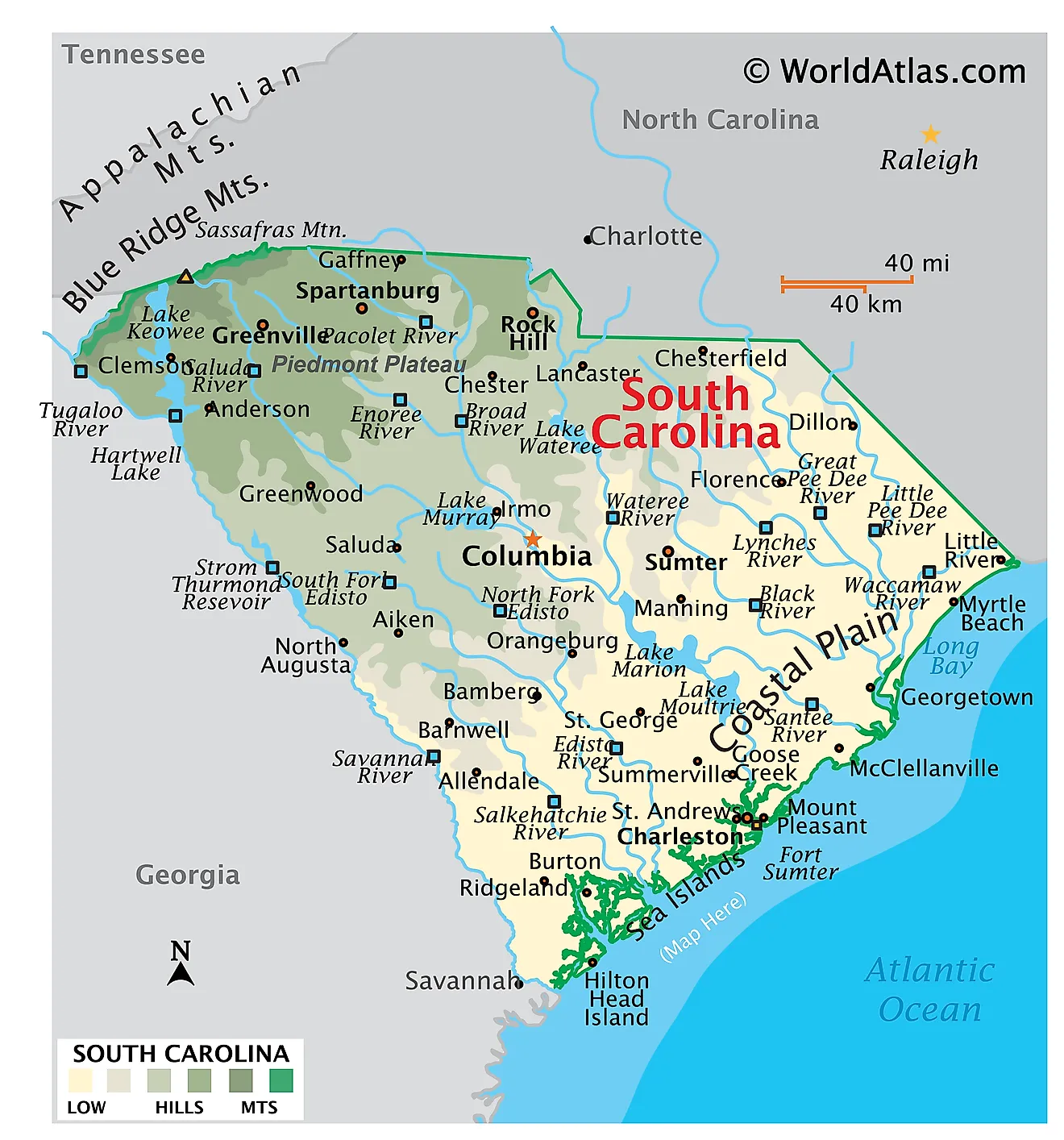
South Carolina is a state in the southeastern United States. It shares its borders with North Carolina to the north, Georgia to the west and southwest, and the Atlantic Ocean to the southeast. The total area of South Carolina encompasses approximately 32,020 square miles (82,932 square kilometers), making it the 40th largest state and the smallest in the Deep South.

South Carolina is shaped like a wedge, its two long sides converging on the coast. Everything about its geography follows a single northwest-to-southeast tilt: the land falls steadily from 3,554 feet in the Blue Ridge corner to sea level on the Atlantic, the rivers all run the same direction, and the bands of rock, soil, and vegetation lie in parallel stripes across that gradient. The state is one of the flattest in the country by average elevation, yet it packs mountain coves, rolling clay hills, ancient sand dunes, blackwater swamp, and salt marsh into barely 260 miles.
Where Is South Carolina?

The state measures roughly 260 miles from its northwestern tip to the sea and about 204 miles at its widest. Its northern boundary with North Carolina is a stepped survey line, the product of a long colonial dispute, while the entire southwestern boundary with Georgia follows the Savannah River and its headwater streams.
With roughly 5.57 million residents, South Carolina is the 23rd most populous state. It is divided into 46 counties. Columbia, at the geographic center on the Fall Line, is the capital, and Charleston, on the coast, is the historic port and the largest metropolitan area.
The Blue Ridge Mountain Region

The Blue Ridge occupies only the extreme northwestern corner of the state — about 2% of its total area, the smallest of the four regions by a wide margin. It is nonetheless the most dramatic. Part of the larger Appalachian chain, it consists of steep-sided ridges and narrow coves cut into hard Precambrian metamorphic rock.
Sassafras Mountain, on the North Carolina line in Pickens County, is the highest point in South Carolina at 3,554 feet (1,083 meters). Some state sources give a slightly higher figure of 3,560 feet.

The region's defining feature is the Blue Ridge Escarpment, a steep wall where the mountain front drops more than 2,000 feet to the Piedmont in only a few miles. Moist Atlantic air forced up this wall produces some of the heaviest rainfall in the eastern United States — over 80 inches a year in places — and the runoff has carved the Jocassee Gorges, a cluster of gorges holding one of the densest concentrations of waterfalls in the country. Raven Cliff Falls, at 420 feet, is the tallest in the state.
The Piedmont

River view with bridge in the distance, Columbia, SC.
Southeast of the escarpment lies the Piedmont, covering roughly a third of the state. This is a worn-down plateau of rolling hills and broad low ridges on ancient crystalline bedrock — granite, gneiss, and schist, the eroded roots of mountains far older than the present Appalachians. Elevations fall gradually from about 1,200 feet at the mountain foot to around 400 feet at the region's lower edge.
Deep red clay soils dominate, a product of intense chemical weathering in a warm, wet climate. Heavy cotton cultivation in the 19th and early 20th centuries stripped much of the topsoil from these hills, and the Piedmont today is largely reforested in loblolly pine. It is also the state's industrial core, with Greenville, Spartanburg, and Rock Hill strung along the Interstate 85 corridor.
The region's southeastern edge is marked by the Fall Line, the boundary where hard crystalline rock gives way to the soft sediments of the Coastal Plain. Rivers drop over shoals and rapids at this contact, and the resulting combination of water power and head of navigation is why Columbia, Camden, and Cheraw all grew up along it.
The Upper Coastal Plain and the Sandhills

The Upper Coastal Plain runs in a broad belt from Barnwell County through the Columbia area northeast toward Marlboro County. It is the transition between the hilly Piedmont and the flat outer plain — gently sloping, dissected by streams, and generally 200 to 600 feet above sea level.
Its most distinctive feature is the Carolina Sandhills, a band of deep white sand immediately below the Fall Line. These are relict dunes and beach deposits marking a shoreline from a period when sea level stood far higher than today. The sand drains so freely that the soil is effectively a desert for plants, supporting a xeric community of longleaf pine, turkey oak, and wiregrass that looks out of place in a humid subtropical state.

Where the Congaree River spills across the inner plain southeast of Columbia, seasonal flooding has built the richest bottomland in the state. Congaree National Park protects roughly 26,000 acres of it — the largest intact tract of old-growth bottomland hardwood forest left in the United States, and home to one of the tallest deciduous forest canopies anywhere in the world.
The Lower Coastal Plain

The Lower Coastal Plain is flatter still, rarely rising above 100 feet, and it grades almost imperceptibly into the sea. Poor drainage is the rule: water moves slowly across the level ground, producing extensive swamp forest, freshwater marsh, and the tannin-darkened blackwater rivers the region is known for.
Scattered across this plain are Carolina bays — thousands of shallow, elliptical depressions, all aligned northwest to southeast and often rimmed with sand on their southeastern edge. Their origin is still debated, with wind and wave action across an earlier shoreline the leading explanation.

The ACE Basin, where the Ashepoo, Combahee, and Edisto rivers converge on St. Helena Sound, is the centerpiece. At roughly 350,000 acres it is one of the largest undeveloped estuarine systems on the Atlantic coast, and much of it is permanently protected. The state's lowest point is sea level along this coast.
The Coast and Barrier Islands

South Carolina's general coastline runs about 187 miles, but its tidal shoreline — counting every creek, sound, and island — measures roughly 2,876 miles, the eleventh longest in the nation. That disparity is the whole story of this coast: it is less a beach than a labyrinth of salt marsh and tidal creek.
The shore divides into three parts. The Grand Strand in the northeast is an almost unbroken 60-mile arc of sand backed by little marsh. The Santee River delta forms a cuspate headland in the middle. Southwest of Charleston lies the Sea Islands stretch, where barrier islands sit close inshore, separated from the mainland by miles of marsh rather than open water.

South Carolina has roughly 35 barrier islands, including Hilton Head, Kiawah, Edisto, Hunting, and Fripp. Unlike the long, thin islands of the Outer Banks to the north, these are short and broad, and many carry mature maritime forest of live oak and palmetto behind their dunes. Because the tidal range here is unusually large — six to eight feet — the marshes behind them are among the most extensive and productive on the Eastern Seaboard.
Rivers

Every major river in South Carolina flows northwest to southeast, following the state's tilt. They fall into two kinds. Red-water rivers rise in the mountains or Piedmont and carry suspended clay; blackwater rivers rise within the Coastal Plain itself and run clear but stained dark by tannins leached from swamp vegetation.
Three systems dominate. The Savannah, at about 301 miles, is the longest and forms the entire Georgia border. The Santee system is the largest by drainage area, gathering the Broad, Saluda, Congaree, Catawba, and Wateree before reaching the sea north of Charleston. The Pee Dee, which begins in North Carolina as the Yadkin, drains the northeastern quarter into Winyah Bay.

The Edisto deserves particular mention: rising entirely within the Coastal Plain and running some 250 miles without a dam, it is often described as the longest free-flowing blackwater river in North America. The Ashley, Cooper, Combahee, and Ashepoo complete the coastal network.
Lakes and Reservoirs

South Carolina has no large natural lakes. Every significant body of standing water in the state is a reservoir, most of them built between the 1930s and the 1960s for hydroelectric power and flood control.
Lake Marion is the largest, covering about 110,000 acres across five counties with 315 miles of shoreline — locals call it the inland sea. Created in 1941 by damming the Santee, it is paired with Lake Moultrie in the Santee Cooper system, the first large public power project in the state. Drowned cypress and tupelo still stand throughout its shallows, giving it the look of a flooded forest rather than an open lake.

Lake Strom Thurmond, on the Savannah River, covers roughly 71,000 acres and is shared with Georgia, where it is known as Clarks Hill Lake. Lake Murray, just west of Columbia, was the largest man-made lake in the world when its dam was completed in 1930. Lake Jocassee, high in the Blue Ridge, is the deepest and clearest, fed by cold mountain rivers and reaching over 300 feet.
Climate

South Carolina has a humid subtropical climate throughout, with long hot summers, short mild winters, and no dry season. Summer averages run in the upper 80s and low 90s °F statewide; winter lows range from around 30 °F in the upstate to the upper 40s on the coast, and the growing season stretches past 290 days in the Lowcountry.
Rainfall averages about 48 inches a year across most of the state but climbs above 80 inches on the Blue Ridge Escarpment, the wettest place in the eastern United States outside the southern Appalachians. The Midlands around Columbia form a mild rain shadow and are noticeably hotter in summer, which is how Columbia earned the nickname "Famously Hot."
Hurricanes are the chief hazard. The coast has been struck repeatedly, most destructively by Hurricane Hugo in September 1989, which came ashore just north of Charleston as a Category 4 and drove a storm surge of about 20 feet into McClellanville — the highest ever recorded on the East Coast at the time. Inland, the state sees tornadoes most often in spring and during tropical landfalls.
South Carolina Geography at a Glance
| Feature | Detail |
|---|---|
| Total area | Approx. 32,020 sq mi (82,932 sq km) — 40th largest state |
| Dimensions | Approx. 260 mi long; 204 mi wide |
| Highest point | Sassafras Mountain, 3,554 ft (1,083 m), Pickens County |
| Lowest point | Atlantic Ocean, sea level |
| Bordering states | North Carolina, Georgia |
| Coastline | Approx. 187 mi general; approx. 2,876 mi tidal shoreline |
| Major regions | Four, northwest to southeast: Blue Ridge, Piedmont, Upper Coastal Plain, Lower Coastal Plain |
| Longest river | Savannah River, approx. 301 mi |
| Largest lake | Lake Marion, approx. 110,000 acres (reservoir) |
| Natural lakes | None of significant size |
| Counties | 46 |
| Capital | Columbia |
Counties Map
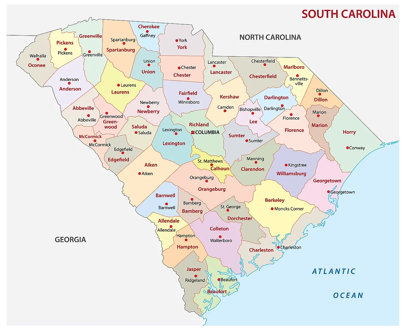
The State of South Carolina is divided into 46 counties. In alphabetical order, these counties are: Abbeville, Aiken, Allendale, Anderson, Bamberg, Barnwell, Beaufort, Berkeley, Calhoun, Charleston, Cherokee, Chester, Chesterfield, Clarendon, Colleton, Darlington, Dillon, Dorchester, Edgefield, Fairfield, Florence, Georgetown, Greenville, Greenwood, Hampton, Horry, Jasper, Kershaw, Lancaster, Laurens, Lee, Lexington, Marion, Marlboro, McCormick, Newberry, Oconee, Orangeburg, Pickens, Richland, Saluda, Spartanburg, Sumter, Union, Williamsburg, and York.
With an area of 82,932 sq. km, the State of South Carolina is the 40th largest and the 23rd most populous state in the USA. Located in the state's center at the confluence of three rivers (where the Saluda River and the Broad River merge to form the Congaree River) is Columbia – the capital and the 2nd largest city of South Carolina. It serves as the administrative, education, and commercial center of the state. It also hosts Fort Jackson – the largest US Army installation for Basic Combat Training. Situated in the southeastern part of the state on the Charleston Harbor is Charleston – the largest city in South Carolina. The city of Charleston serves as the chief port and cultural hub of the state.
Where is South Carolina?
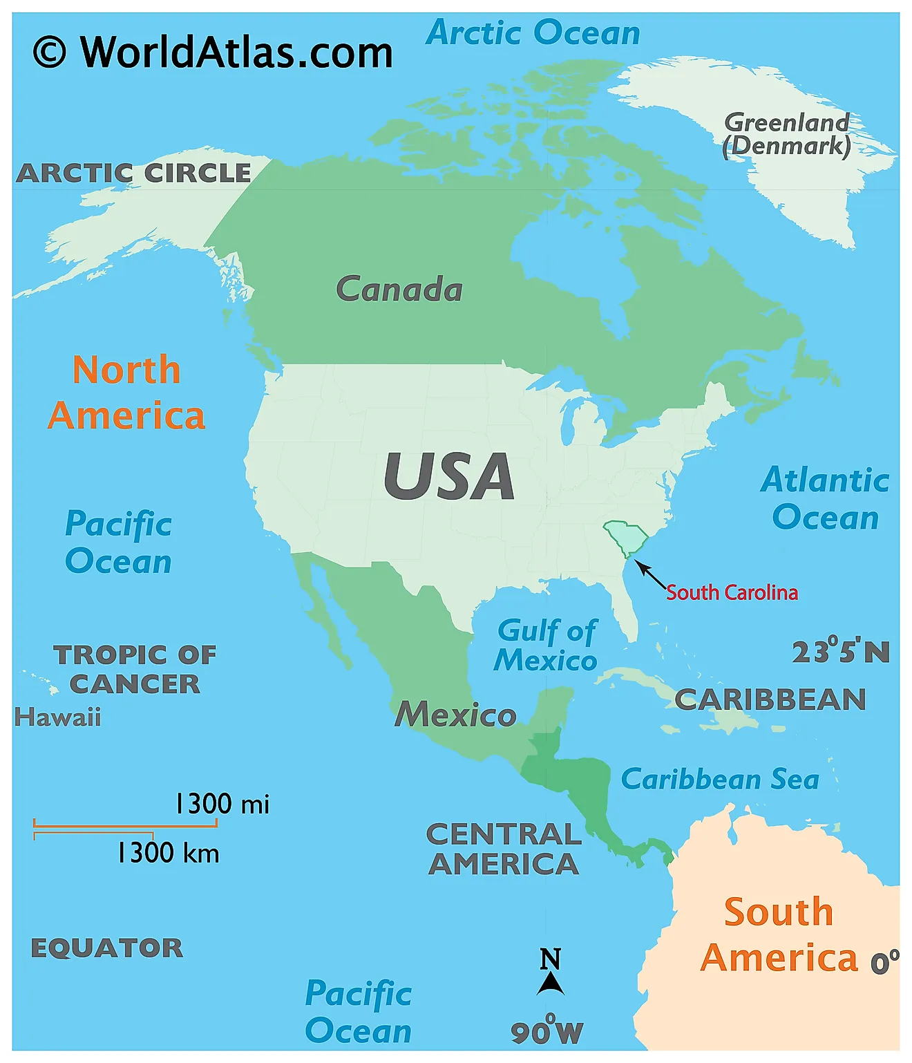
The State of South Carolina is located in the south-eastern region of the United States. South Carolina is bordered by the states of North Carolina in the north; and by Georgia in the southwest. It is bounded by the Atlantic Ocean in the southeast.
Regional Maps: Map of North America
Outline Map of South Carolina
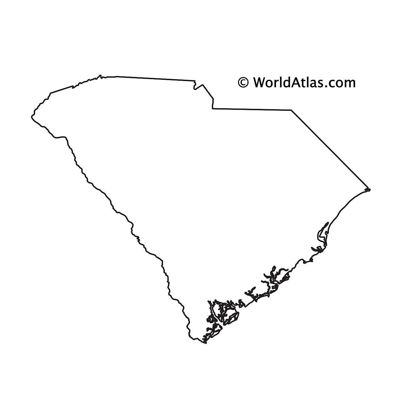
The above blank map represents the State of South Carolina, located in the south-eastern region of the United States. The above map can be downloaded, printed and used for geography education purposes like map-pointing and coloring activities.
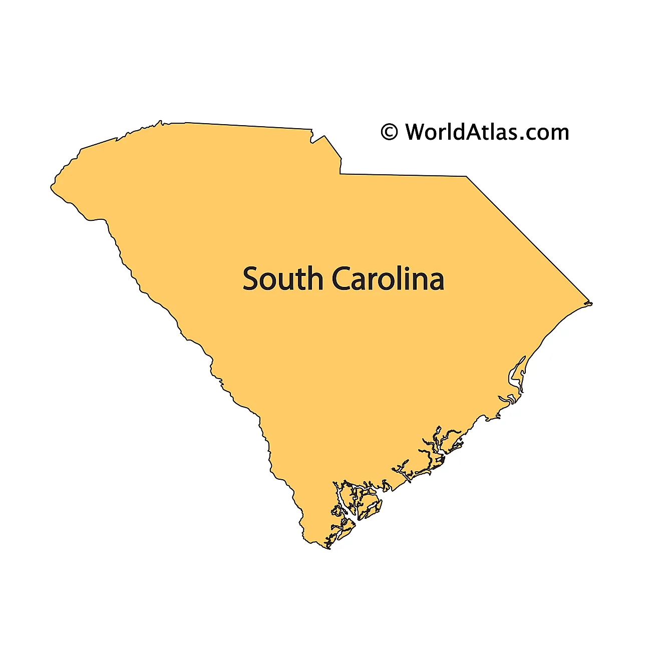
The above outline map represents the State of South Carolina, located in the south-eastern region of the United States. The state's shape resembles an inverted triangle.
Key Facts
| Legal Name | State of South Carolina |
|---|---|
| ISO 3166 Code | US-SC |
| Capital City | Columbia |
| Major Cities |
|
This page was last updated on September 17, 2026