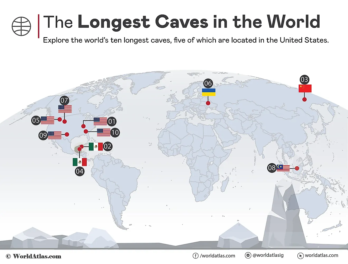
St. Barts Island
St. Barts Island or Saint Barthélemy is an Overseas French Collectivity positioned between the Caribbean Sea and the North Atlantic Ocean. Along with the island territories of Guadeloupe, Martinique, and Saint Martin, the St. Barts Island forms a part of the French Antilles and is situated in the Leeward Islands of the northeastern group of Caribbean Islands.
Where Is St. Barts Island?

The volcanic island of St. Barts is situated about 35 km southeast of Saint Martin Island and to the north of the island nation of Saint Kitts and Nevis. The island is located about 250 km to the east of Puerto Rico and the US Virgin Islands, and northeast of St. Eustatius and Saba Islands.
Geography

Covering an area of only 25 km2, Saint Barthélemy Island has a length of about 17.5 km and a maximum width of 4 km. The Island is completely surrounded by shallow reefs and features a mountainous terrain with several hills and valleys. Situated in the island’s eastern part is Morne du Vitet which rises to an elevation of 286 m and is the highest point on Saint Barthélemy Island. There are no natural rivers and streams on the island. The island experiences an arid, tropical maritime climate with average temperatures around 25 °C.
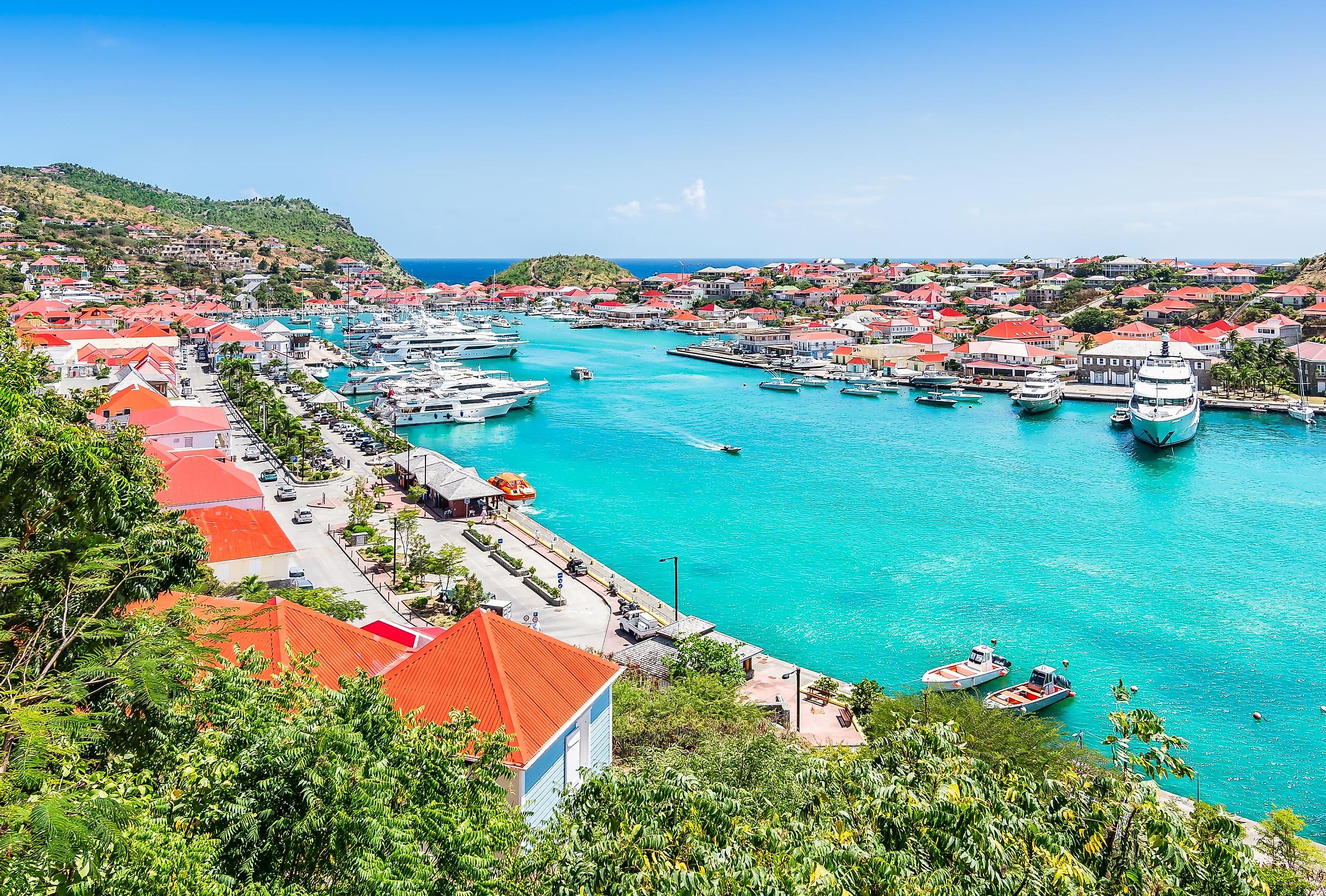
The eastern part of St. Barts is comparatively much wetter than the western part. There are about 22 public beaches on the island. Some of these notable beaches are Grand-cul-de-sac, Anse de Flamands, Le petit Anse, Anse du Colombier, Anse du Gouverneur, Anse de Grande Saline and Anse de Grand Galet (Shell Beach). Located in the island’s southwestern part is the city of Gustavia, the island’s capital city and its chief harbor. Most of the island’s population is mainly concentrated in and around the capital city.
Wildlife

The arid terrain of the island features different plants like sea grapes and palms. Mangroves and shrubs are also found in coastal swamps. Coconut palm trees have also been imported to the island from the Pacific Islands. Some of the important floral species that are found here include the fragrant frangipani, flamboyant tree, wild trumpet, sabal palm, and the Manchineel tree. Many flowering plants like bougainvillea, hibiscus, oleander, and Mexican creeper are found in the irrigated areas, while cactus and other succulents are found in the dry regions.
Notable marine species that are found around the island include anemones, sea cucumbers, urchins, conches, eels, ghost crabs and hermit crabs, and several other aqua faunas. The significant fish that are found here are blue and brown chromis, trumpet fish, and surgeonfish. The island hosts a vibrant population of seabirds like brown pelicans, snowy egrets, herons, belted kingfishers, frigate birds, bananaquits, the Antillean crested hummingbird, the green-throated Carib, broad-winged hawks, and Zenaida doves. Different marine mammals like dolphins, whales, and porpoises are also found. Turtles are common around the island, and the sea turtle species that have been observed include the green turtle, hawksbill turtle, and the leatherback sea turtle. These turtles are endangered species and are therefore currently protected. Covering an area of only 12 km2, the Reserve Naturelle is a marine nature reserve in Saint Barthélemy. This marine reserve protects the endangered sea turtles, seagrass, and the coral reefs of the island.
Brief History

The St. Barts Island was discovered by Christopher Columbus in 1493 and was named by him in the honor of his brother Bartoloméo. In 1648, this Caribbean island was first settled by French colonists. However, the island was sold by Louis XVI to Sweden in 1784, who renamed the island’s largest town in the honor of the Swedish King Gustavia III and declared the town as a free port. During the colonial wars of the 18th century, the island served as a supply and free-trade center for the Spanish, British and French ships in the Caribbean Sea. The island was repurchased by France in 1877 and placed under the administration of Guadeloupe. The island retained its status as a free port along with some other Swedish denominations. In a 2003 referendum, the island residents voted to separate from Guadeloupe, and on February 22, 2007, the island became a French Overseas Collectivity. In January 2012, St. Barts Island became a member of the European Union.
The island’s economy is based on tourism and it has been estimated that more than 200,000 tourists visit the island annually. The island serves as a favorite tourist destination for various celebrities and other wealthy people mainly during New Year’s Eve. To cater to this boost in tourism, many luxury hotels and resorts have been constructed on the island. Different agricultural products like fruits, cotton, and different vegetables are also grown on the dry and rocky terrain of St. Barts Island.