Azores Islands
Although Portugal is not an island country, it does possess numerous islands. Some popular Portuguese islands are found in the Madeira and Azores Archipelagos in the Atlantic Ocean, as well as off the coast of the Algarve. The Azores Archipelago is a group of nine islands in the North Atlantic region. The islands and islets are of volcanic origin, some of which have been inactive since they were formed. The archipelago is part of the Autonomous Region of the Azores. The Azores, alongside Madeira and continental Portugal, form the Republic of Portugal.
Contents
Where Are The Azores Islands?

The Azores Islands are located in the middle of the North Atlantic Ocean, approximately five hours in flight from South America and two hours from Europe. The archipelago, alongside Madeira, Cape Verde, and the Canary Islands, is part of Macaronesia. The island group is about 1,400 km west of mainland Portugal. The Autonomous Region’s capital, Ponta Delgada, is situated on São Miguel Island, the archipelago’s largest and most populous island. Flores Island is Europe’s westernmost inhabited point.
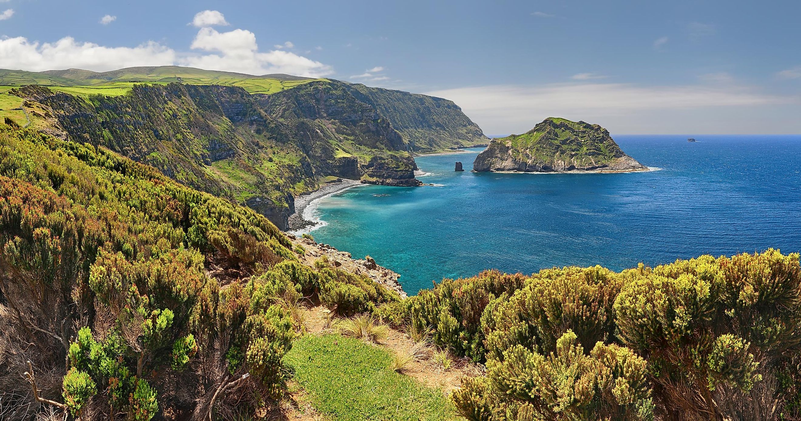
Geography

The Azores archipelago comprises nine major islands and eight minor islands. The islands lie in a northwest-southeast direction, and are divided into three groups: northwest, central and eastern. The archipelago and the surrounding water body are an Exclusive Economic Zone of approximately 1.1 million km2, with the westernmost point (Flores and Corvo islands) located on the North American tectonic plate. São Miguel is the largest island, spanning about 759 km2, while Mount Pico, located on Pico Island, is the highest point on the archipelago, rising 2,351 m above sea level.
The Azores Islands are volcanic islands that originated from the Azores Plateau. The island group lies above the Azores Triple Junction, a junction where three of the world’s main tectonic plates (Eurasian, North American, and African) meet. All the islands are within the boundary dividing the African and Eurasian plates except for Flores and Corvo located on the North American plate. The tectonic structures existing in the Azorean island region are the Terceira Rift, mid-Atlantic Ridge, Gloria Fault, and the Azores Fracture Zone. The Mid-Atlantic Ridge is the main structure between the African-Eurasian Plate and the North American Plate crossing the Azores Plateau. Terceira Rift extends between Gloria Fault and the Mid-Atlantic Ridge for about 550 km from Graciosa Island to the Formigas islets.
Islands

The island group comprises nine major islands and several islets. Six of the islands cover at least 100 km2. São Miguel is the archipelago’s largest and most populated island with over 150,000 residents, including 50,000 people in Ponta Delgada. Pico Island is the second-largest island, covering 446 km2. It has a population of about 14,000 people and hosts Mount Pico, Ponta do Pico in Portuguese, Portugal’s highest mountain. Formed around 300,000 years ago, Pico Island the Azores’ most recently formed island.
Terceira Island has a population of 56,000 people and spans 403 km2. The archipelago’s historic capital, Angra do Heroísmo, is located on the island and is now a UNESCO World Heritage Site. Although Terceira Island is composed of old and extinct volcanoes, it is still one of the Azores’ active volcanic islands. São Jorge is the fourth-largest island, covering 246 km2. It is separated from Faial and Pico Islands by the Pico-São Jorge Channel. The island is narrow, with a length of 53 km and a width of 8 km. It has a population of around 9,500 people.
Faial Island spans 173 km2 and is located to the east of Pico Island and northeast of São Jorge. It is home to some 14,500 people. Flores Islands forms part of Azores' western island group and spans 143 km2, with over 3,000 people. The other three major Azorean islands are Santa Maria (97 km2), Graciosa (62 km2), and Corvo (17 km2).
Climate
The Azores Archipelago lies roughly on the same latitude as the Lisbon area (mainland Portugal’s southern half), giving it a tepid, oceanic subtropical climate. Daily high temperatures range between 16 and 25 °C (61-77 °F). The average temperature on the archipelago is 17 °C (64 °F), with July being the driest month and November the wettest month.
The water temperature ranges from 17 °C (63 °F) in winter and 25 °C (77 °F) in summer. The annual mean relative humidity ranges between 73% and 80%, averaging 76%. The average annual precipitation increases westwards and averages 6,300 mm on Mount Pico, 1,600 mm in Flores, and 700 mm in Santa Maria. The Azores Islands experience the warmest winter in Europe.
Brief History
It has been suggested that human presence on the Azores Islands could date back 2,000 years ago. However, there has been no conclusive evidence that human occupation on the islands precedes the arrival of the Portuguese in the 15th century. The Europeans at least knew of the islands as early as the 14th century, and they did appear in maps and sea voyage accounts.
Before the Portuguese could settle on the islands, they brought in sheep that would provide food for future settlers. Gonçalo Velho Cabral was among the islands’ first settlers, arriving in 1436 to establish colonies on Santa Maria and São Miguel Islands. Settlers mainly came from the Portuguese provinces of Minho, Algarve, Ribatejo, and Alentejo.
The Portuguese Civil War in the early 19th century had a great impact on the Azores. When Liberals won against the monarchists, they made Terceira Island their new headquarters. During the 18th and 19th centuries, the archipelago experienced tremendous growth, including industry establishment and the introduction of more new crops. In 1976, the archipelago became a Portuguese Autonomous Region.
Human Settlement

The Azores Archipelago is one of two Portuguese autonomous regions. It has its own government and legislature, with governmental organs including executive and legislative assemblies. The Legislative Assembly comprises 57 elected deputies who serve a 4-year term. The presidency is composed of the president, vice president, and regional secretaries. One of the seven regional secretaries represents the rest in the Council of ministers. The executive branch is based in Pont Delgada.
The Azores Islands are divided into 19 municipalities, which are divided further into civil administrative parishes. The islands have a combined population of approximately 247,000 people, with more than half of the people living on São Miguel. Ponta Delgada is the largest city on the archipelago with about 68,000 people, while Angra do Heroísmo is the second-largest city with 35,000 people.
Wildlife

The Azores Islands have unique flora and fauna due to their location in the Palearctic realm. The islands' Laurel forests are home to numerous species, including endemic plants and animals. Of the over 6,100 terrestrial species, about 410 are endemic. About three-quarters of the endemic species are animals, mainly arthropods and mollusks. Azores vegetation has historically attracted lumbers because of the valuable wood found here. Part of the vegetation has also been cleared for agriculture and human settlement.
At least two endemic bird species still survive on the archipelago, including the Azores bullfinch restricted to laurel forests, and the Monteiro’s storm petrel. The Formigas islets, including Dollabarat Reef, are rich in marine species, such as sharks, black corals, sea turtles, and whales. The Azorean Marine Park, covering 135 466 km2, is designated to protect the marine species.


