Kanawha River
The Kanawha or Great Kanawha River is West Virginia’s largest inland waterway, flowing for 156 km. The river serves as a tributary of the Ohio River and, through it, drains into the Mississippi River drainage basin. The word Kanawha comes from the Iroquois term Kaihnawha, which roughly means waterway or way for the canoe. The river has a drainage area of 8,450 square miles and is the fourth largest tributary of the Ohio River. With its deposits of coal and natural gas, the area around the Kanawha River Valley has been critical to local settlement and development. In the 1800s, the Valley and drainage basin began to be developed for the mining industry, an activity that continues into the modern era.
Geography And Geology Of Kanawha River

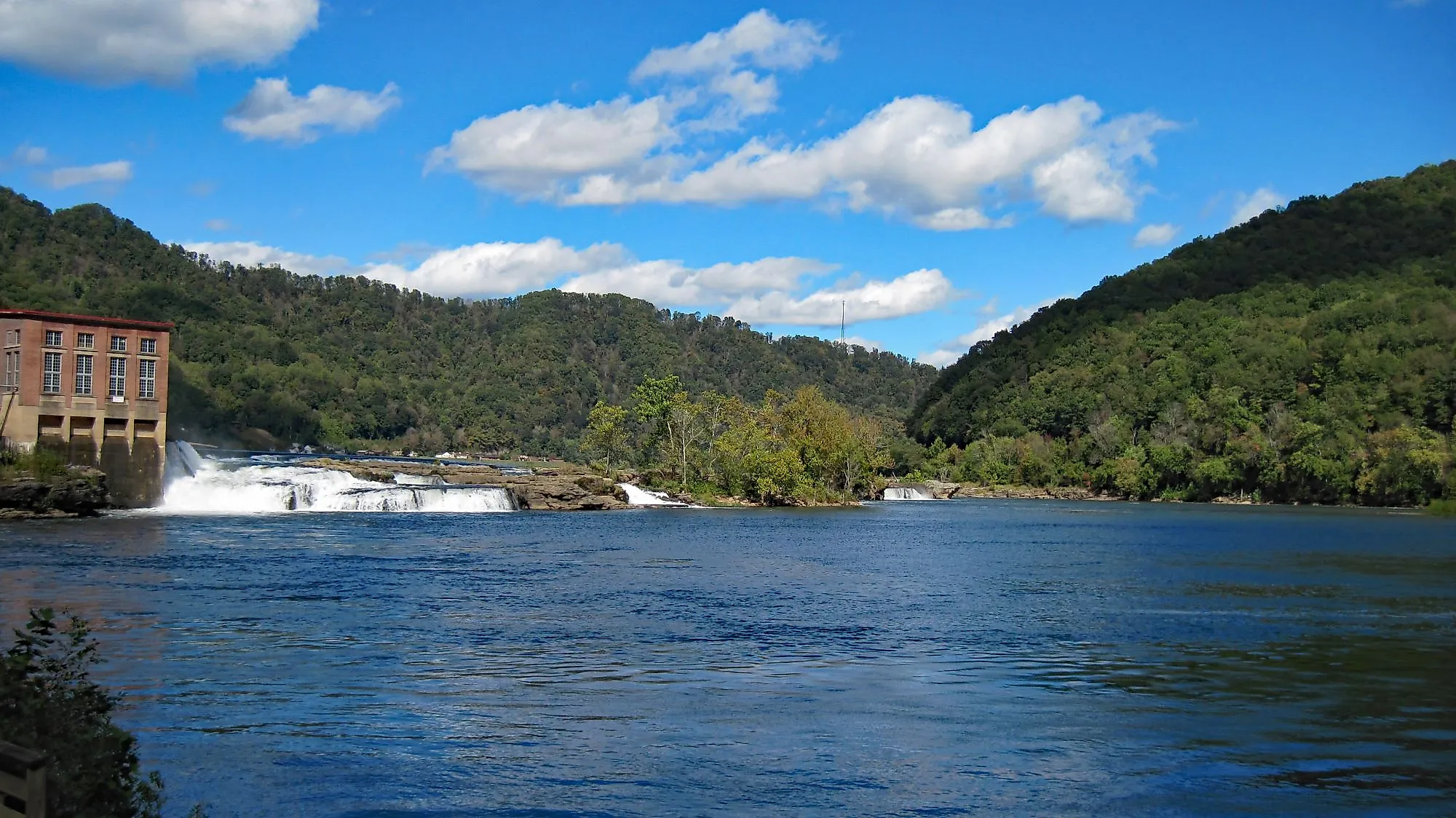
Rivers and creeks in the mountains of North Carolina create the New River, which flows downhill into Virginia and then West Virginia. To the northeast, on Gauley Mountain in West Virginia, three streams converge to form the Gauley River, which flows 105 miles west-southwest to the town of Gauley Bridge. There, it converges with the New River to form the Kanawha Falls, and the Kanawha River begins its flow to the Ohio River. The Kanawha Falls span the whole width of the flow and drop from a height of about 15 feet. A dam just above the falls diverts water into a hydroelectric power generation facility.

The river flows largely from southeast to northwest, entering the Ohio River at Point Pleasant in Mason County. The river creates a winding course through the Allegheny Plateau, a geological feature that stretches in a kind of arc from southeastern Ohio through West Virginia and into western Pennsylvania and New York State. It is characterized as a dissected plateau consisting of sandstone and shale, with seams of coal running between them. Within the Plateau, the Kanawha River Valley was created by a continental ice sheet, which dammed a prehistoric version of the river in the last Ice Age. It formed a huge lake, which deposited silt and organic material in the Valley. The Kanawha River and its tributaries started to form after the ice receded. The mountainous area ranges from elevations exceeding 4,000 feet above sea level down to roughly 560 feet at the river's mouth in Point Pleasant.

The Elk River converges with the Kanawha at Charleston. The Elk River, originating in Pocahontas County, is important to the timber industry. Logs were sent down the Elk to mills that sprang up around Charleston. The Coal River is another major tributary of the Kanawha, flowing 59 miles north from Boone County to St Albans, West Virginia. Some geologists believe that the New River is actually one of the oldest in North America and perhaps the world. They believe that it was once a much larger river, diverted into the Ohio and Kanawha Rivers by glacial ice during the Pleistocene era.
Climate Of Kanawha River

The climate of the Kanawha River Valley and region is classified as a humid subtropical climate, as per the Köppen Climate Classification. Summers are humid, with temperatures warm to hot, and winters are cold. Average daily temperatures range from 38 °F to 24 °F in January and from 87° to 62 °F in July. At higher elevations, the climate can become humid continental, with cold winters and cool summers that average daytime highs of 72 °F in July. Average precipitation in Kanawha County ranges from 3.6 inches in November to 7.4 inches in July and May, with rain days ranging from 10 in July to 5 in November. The average daily discharge of the river is 7,040 cubic feet per second, based on 81 years of record keeping. The maximum discharge was measured in 1958 at 43,900 cubic feet per second.
Ecology Of Kanawha River
The river's strong connection to local industry, including the many coal mines located in the Valley, means that there is significant industrial pollution in the river and its many tributary creeks and streams. Despite the concerns over pollution and contaminants, 118 different species of fish have been identified in the river downstream of Kanawha Fall. They include the Appalachia darter, bigmouth chub, bluestone sculpin, candy darter, Kanawha darter, Kanawha minnow, and New River shiner. Several species of bass thrive in the river, along with catfish, walleye, sunfish, carp, sturgeon, and skipjack herring. The river is home to the sheep nose mussel, listed as an endangered species.
The Kanawha State Forest, located just south of Charleston, is home to many species of birds, including thrushes, redstarts, warblers, Acadian flycatchers, several species of swallows, and red-shouldered hawks. The area around Kanawha Falls is part-time home to many seasonal waterfowl, including mallard ducks, buffleheads, mergansers, and goldeneye ducks. The woods of the Valley are home to various animals often hunted as game, including bears, boars, deer, and turkey. Beaver, fisher, and river otters were once hunted to extinction but have been reintroduced to the region. Most of the vegetation consists of old-growth forests, with hardwood oaks and poplars, along with hickory and black gum trees and eastern hemlocks. Minks and muskrats also live along the river banks and in shallow areas, together with several species of salamanders and other amphibians. In the forest, there are copperhead snakes, black rat snakes, and snapping turtles, along with lizards and skinks.
Brief History

Evidence such as hunting tools and weapons show that Paleo-Indians lived in the area from about 12,500 years ago, just after the last Ice Age, for about 2,500 years. They evolved or were replaced by the Archaic Indians, who left stone and flint tools. For about 3,000 years, they lived in the area and began to grow their own food instead of relying on hunting and gathering. The earliest Woodland Indians of the Kanawha Valley and region were the Adena People, who began to make themselves known about 2,500 years ago. They are also called the Mound Builders for the hundreds of stone and earth mounds they constructed throughout the Valley. Their civilization developed into a system of fortified villages, and they lived in the Valley until about the 18th century, when the Iroquois drove them out.
When the first European settlers arrived, the area was used as hunting territory for the Iroquois, Shawnee, and Cherokee nations. They looked at the New River and Kanawha River as being a single flow, and some early white settlers agreed. The first white settler arrived in the present-day Point Pleasant in 1764. The Treaty of Fort Stanwix of 1768 established the boundaries between Native American lands and the Thirteen Colonies. In April 1774, documents show that 2,000 acres (or 8.1 km2) of land was surveyed for Col. Washington in the area of St. Albans, West Virginia. Washington later secured additional lands that had been originally granted to French and Native war veterans. He eventually claimed four tracts totaling 23,216 acres, which he still owned at his death.

Great fluctuations through the river’s course prevented large-scale navigation for some time. From Point Pleasant to Kanawha Falls, the river was navigable from the early 19th century, although water levels still fluctuated significantly, and there were often rocks and other hazards to tackle in low water areas. There was a concerted effort to remove these, and by 1840, the river could be used to transport flatboats with cargo such as salt, timber, and coal. The first locks and dams were constructed in 1875 to stabilize the river’s water levels. As flooding became an issue in low-lying areas, more locks and dams were constructed over the ensuing decades. Locks and dams at London, Marmet, and Winfield create an even flow for 90 miles of the river from Deepwater (just north of Charleston) to Point Pleasant. In 1937, 6,705 acres of land were purchased from the mining and logging companies by the West Virginia Conservation Commission to create the Kanawha State Forest. A small lake was created with a dam over Davis Creek, and another 2,500 acres were acquired in 1942.


