6 Best Natural Wonders To Visit In Utah This Year
Utah is an unbeatable destination for those seeking adventure among some of America's most incredible geological landmarks. The state contains an unusually dense concentration of unique geological formations, all shaped by eons of erosion, receding ancient inland seas, and other powerful forces of nature. Sandstone arches, deep canyons, hoodoo fields, and countless other points of interest showcase why Utah remains a focal point for researchers and sightseers alike exploring the stark but wonderful desert landforms of the Wild West. So pull out your map and start planning your visit to the six best natural wonders of Utah.
Zion Canyon

One of Utah’s most recognizable destinations is located within the famous Zion National Park, a canyon system carved over millions of years by the Virgin River. It is defined by its massive Navajo sandstone cliffs, some of which rise more than 2,000 feet above the canyon floor, creating steep walls that seemingly glow shades of red, orange, and cream that especially pop during sunrises and sunsets.

Erosion and flash flooding continue to shape this terrain, deepening narrow slot canyons and exposing layered rock that dates back roughly 190 million years. Furthermore, Zion’s elevation range, from about 3,700 to over 8,700 feet, supports surprisingly varied and lively ecosystems, including desert scrub, hanging gardens fed by seeps, and ponderosa pine forests on higher plateaus. Wildlife is also quite diverse here, with mule deer, desert bighorn sheep, and nearly 300 bird species recorded.
To explore on foot, trails such as Angels Landing and The Narrows reveal how water and time have sculpted this deeply (pun intended) iconic landscape of the American Southwest. It is advised to come in the fall or spring, as summer temperatures here can border on dangerous, especially during strenuous outdoor activities.
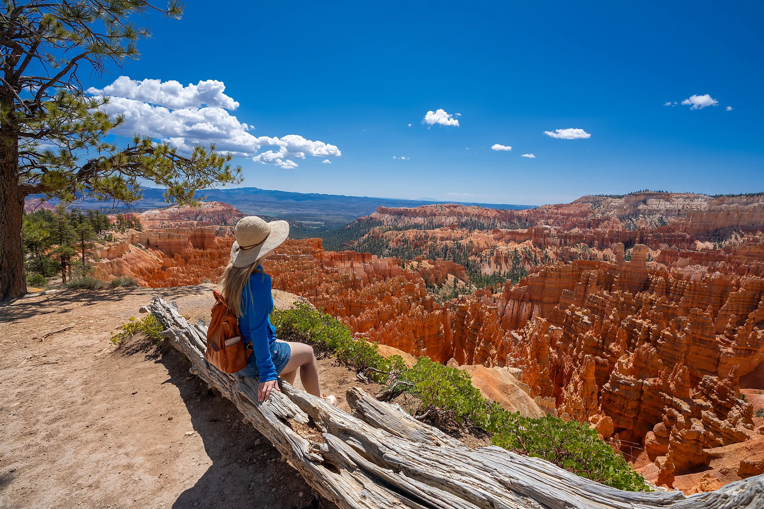
Bryce Canyon

Another remarkable natural indentation in southern Utah is in Bryce Canyon National Park, known for having the world’s largest concentration of hoodoos- tall, thin rock spires formed through a combination of erosion and freeze-thaw cycles. Despite its name, Bryce is not a true canyon but a series of natural amphitheaters carved into the edge of the Paunsaugunt Plateau. These formations developed in layers of soft limestone, mudstone, and sandstone within the Claron Formation and date back roughly 50 million years.
To this day, water continues to seep into cracks, freezing during cold nights and expanding on a regular basis, gradually widening fractures and breaking the rocks even further apart. Over time, this process has isolated pillars that can rise more than 150 feet tall!
The overall high elevations in the park range from about 8,000 to over 9,000 feet, also creating cooler temperatures than many other Utah desert landscapes and giving it a particularly wintery vibe as snow dusts the red/orange hoodoos around the holiday season. Regardless of the time of year, though, you'll want to bring your camera to this immensely beautiful spot.
The Hoodoos Of Goblin Valley

For a truly otherworldly experience, check out Goblin Valley State Park, where thousands of mushroom-shaped hoodoos cover a broad desert basin. These formations, often called “goblins,” developed within the region's Entrada Sandstone, starting roughly 170 million years ago during the Jurassic period. Over time, wind and water erosion removed softer surrounding rock while leaving behind more resistant sections that gradually took on their distinctive pedestal shapes.
Many of these hoodoos stand between 5 and 15 feet tall, with rounded caps perched on narrow bases that resemble fungi-like figures scattered across the valley floor. The formations are especially concentrated in several clusters, such as the Three Sisters and other dense “valleys” of goblins.
Unlike many protected geological features in the region, visitors here are allowed to walk directly among the hoodoos, giving you the chance for a uniquely intimate look at this natural wonder. The stark terrain sits within Utah’s San Rafael Desert, too, creating one of the most surreal but easily accessible hoodoo fields in the entire world that can be enjoyed all year-long.
Valley of the Gods

Located in southeastern Utah near the Arizona border, Valley of the Gods is another remote desert landscape, this time filled with towering sandstone buttes, mesas, and monoliths rising dramatically from a broad valley floor. It is often referred to as a less crowded, smaller, yet just as beautiful version of its neighboring Monument Valley, which was made famous by movies such as Forest Gump and The Searchers.
The formations here belong to the Cedar Mesa Sandstone Formation, deposited roughly 300 million years ago when the region was covered by coastal sand dunes and shallow seas. Over millions of years, the forces of water and wind chipped away at surrounding rock layers, leaving behind isolated towers that now dominate the skyline, many of which rise 1,000 feet or more above the valley floor.
The area is managed by the Bureau of Land Management and remains largely undeveloped, preserving its desolate desert scenery and wide open views. If you do decide to drop by, however, a 17-mile unpaved scenic road loops through the valley, passing notable formations with informal names such as Seven Sailors and Rooster Butte.
Delicate Arch

Delicate Arch is perhaps the most widely recognized emblem of the Southwest, even being featured prominently on Utah's license plates. If you haven't happened to have seen it somewhere or other, it is a freestanding sandstone arch located in Arches National Park, standing about 52 feet tall with a width of roughly 46 feet. It is the largest free-standing arch in the park and, as mentioned, has become an enduring symbol of the state's unparalleled outdoor scenery.
Interestingly, unlike many arches that are attached to cliff faces, Delicate Arch stands alone on a slick, rocky ridge, making it particularly eye-catching against the surrounding high desert. The structure also overlooks a wide basin of sandstone domes and distant mesas, with its isolated position and distinctive shape having made it one of the most photographed and accessible geological formations in the western United States, let alone in Utah.
Bonneville Salt Flats

Stretching across western Utah near the Nevada border, the Bonneville Salt Flats cover roughly 30,000 acres and represent the remnants of ancient Lake Bonneville, a massive inland sea that existed during the last Ice Age around 14,000 years ago. As the climate warmed and the lake gradually evaporated, it left behind thick mineral deposits dominated by sodium chloride.
Located more specifically now along the edge of the Great Salt Lake Desert, the flats remain a striking example of Utah’s ancient geological history. Today, the surface appears as a vast white crust of salt that can reach several feet thick in places, giving it the appearance of a frozen lake. It is anything but, however, and seasonal flooding has been known to briefly cover parts of the flats with shallow water before evaporation reforms the hard, reflective surface. Its extremely flat terrain, one of the flattest natural surfaces on Earth, has also made the area highly sought-after for land speed racing events.
See The Wonders Of Utah For Yourself
Utah is an unbeatable destination for those in search of an adventure among some of America's most incredible geological landmarks. From deep valleys to impossibly flat expanses of desert and snowcapped mountains, the Beehive State will wow you around every corner, whether you're on a quick getaway from Salt Lake City or embarking on a multi-day road trip. The above-mentioned spots represent just a handful of the natural gems you can find here.