5 Best Natural Wonders To Visit In Nebraska This Year
Nebraska has a number of natural sites worth a detour. Many are tied to specific earth processes that have been going on for millions of years: erosion and volcanic ash deposition and stabilized dune systems. Formations like Chimney Rock and Scotts Bluff jut directly from the Great Plains with little to no visual barriers. Places like Ashfall Fossil Beds preserve intact fossil layers from a single ashfall event. Broader wonders like the Nebraska Sandhills show how some of the world's biggest dunes can remain fixed over long periods. The five sites below are spread across the state and reachable by standard roads.
Chimney Rock National Historic Site

Chimney Rock stands over 300 feet above the surrounding North Platte River valley, formed from Brule clay and volcanic ash layers capped by erosion-resistant sandstone. It once served as a key landmark for emigrants on the Oregon, California, and Mormon Trails, mainly between the 1830s and 1860s, with thousands recording it in journals as a midpoint marker.

The formation has lost measurable height since the 19th century due to ongoing erosion, though its narrow spire remains intact. The site now includes a visitor center and museum located about half a mile from the formation, with exhibits focused on westward migration and regional geology. The pristine prairie landscape surrounding it supports native species such as pronghorn and red-tailed hawks.
The area is accessible via paved roads and short walking paths, making it one of Nebraska's most documented and historically referenced landforms, conveniently just off Highway 92.
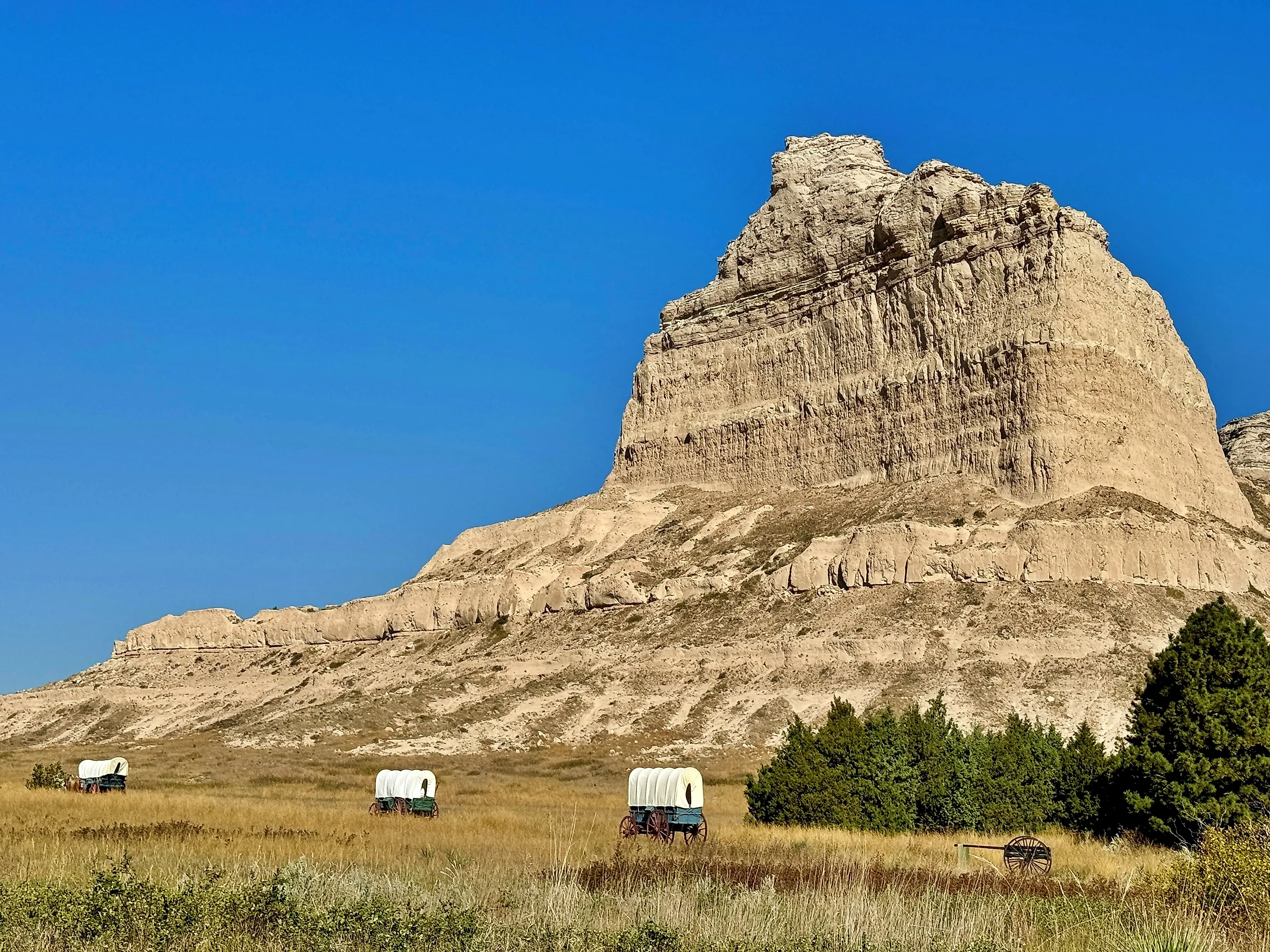
Scotts Bluff National Monument

Scotts Bluff is another prominent landmark, this time rising around 800 feet over the nearby North Platte River. It forms a layered array of siltstone and sandstone shaped by erosion over millions of years.
Sitting just outside the city of Gering, it historically marked another major waypoint for travelers, with emigrants funneling through Mitchell Pass at its base during westward migration in the mid-1800s. Going back even further in time, fossil evidence in the region documents ancient mammals that lived here during the Oligocene epoch.

Various hiking trails and scenic drives trace both the base and upper slopes. A paved summit road climbs 1.6 miles to the top, where overlooks provide clear views of the Platte Valley and surrounding plains. The monument preserves several distinct formations, including Eagle Rock and Saddle Rock, along with remnant prairie ecosystems scattered about.
Ashfall Fossil Beds State Historical Park

The Ashfall Fossil Beds preserve a mass die-off site created about 12 million years ago when volcanic ash from eruptions near the present-day Idaho-Nevada border settled over this region of northeastern Nebraska. The ash blanketed water sources, leading to the deaths of rhinoceroses, three-toed horses, camels, birds, and countless other plants and animals, many of which remain preserved where they fell. More than 200 complete skeletons have been excavated here, making it one of the most complete Miocene fossil sites in North America.

The main quarry is housed inside the Hubbard Rhino Barn, where you can view active excavation areas and in-place fossils protected under cover. The nearby prairies are also worth exploring, with a number of trails and interpretive stops explaining the ashfall event, the fossilization process, and the species identified at the site through ongoing research.
Toadstool Geologic Park

For one of the best badlands experiences in Nebraska, Toadstool Geologic Park is full of exposed terrain shaped by eons of erosion within the broader White River Formation, where layers of rock dating back roughly 30 million years can be seen in open air.
Wind and water have carved local clay and siltstone into pedestal formations, where harder caprock protects narrower columns beneath, creating the park's distinctive "toadstool" shapes. The area also contains a high concentration of Oligocene fossils, including early horses, oreodonts, and rhinoceros relatives, many of which have been documented through controlled excavations.

See Toadstool for yourself on its one-mile interpretive loop trail, which passes directly through the densest formation field, with markers explaining the stratigraphy and fossil record. The park also sits within the Oglala National Grassland, where even more undeveloped land hosts other unique geological features and campgrounds for an overnight stay.
The Nebraska Sandhills

The Nebraska Sandhills cover roughly 19,000 square miles of north-central Nebraska, forming the largest stabilized dune region in the United States. Despite their size, the area remains sparsely developed, with limited paved roads and large ranches dominating land use.
The dunes, built from wind-deposited sand during the late Pleistocene era, are now blanketed by mixed-grass prairie. That cover has prevented their large-scale movement with the wind, but it also makes them look less like a typical desert and more like grazing land. Elevation changes here are gradual, with rolling hills and shallow valleys extending for miles without interruption.

The region also contains thousands of shallow lakes and wetlands, created by a high water table within the underlying Ogallala Aquifer. It intersects with the Niobrara National Scenic River, popular for paddling, rafting, and fishing. These water sources support large numbers of migratory birds, including big concentrations of sandhill cranes during seasonal movements.
Experience These Outdoor Attractions In Nebraska Today
These natural highlights showcase the Midwest's surprisingly interesting geology. From the eroded spires of Chimney Rock to the fossil layers at Ashfall and the dunes of the Sandhills, each site reflects the specific processes that shaped this stretch of the United States. In 2026, you can string them together to form a road trip in Nebraska that is full of sightseeing and learning alike.