Virunga National Park, DRC
Virunga National Park is located in the eastern part of the Democratic Republic of Congo, within the Albertine Rift Valley. It includes a lush landscape that ranges from the Semliki River Valley to the Rwenzori Mountains, Mount Nyiragongo, and Nyamuragira. The presence of these volcanoes has shaped the landscape of the park over the years, helping to encourage a diverse range of plants and animals there. Virunga covers an area of 8,090 km2.
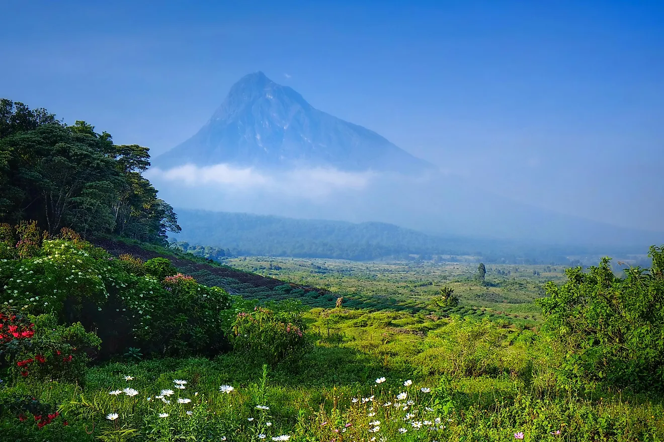
Geography

Virunga National Park is located along the Eastern border of the Democratic Republic of Congo, within the Nile River watershed. The landscape is highly diverse within the park, from lowlands to mountain ranges. The northern portion of the park includes the Semliki River basin. The basins and lowland areas include both wetlands and river valleys, forming the lowest elevation in the park at only 680 m above sea level.

The Semliki is one of the largest major rivers in the area at 140 km long and flows from Lake Edward to Lake Albert through the DRC and Uganda. Lake Albert is situated against the Albertine Rift, another prominent geographical feature of this portion of the park. The rift makes up the western branch of the larger East African Rift, a tectonic border that runs through a number of Eastern African countries and is responsible for several mountain ranges in the area. Within the Virunga National Park, these mountain ranges include the western edge of the Rwenzori Mountains (the bulk of which lie in Uganda as part of the Rwenzori National Park), and the highest peak in Virunga, Mount Stanley, which has an altitude of 5,109 m. This rift area and mountain range are full of lush montane forests, common in this region of the DRC and surrounding countries.

The southern portion of the park reaches as far as Lake Kivu. As this region also borders a tectonic plate, there are three prominent volcanoes in the area: Nyamulagira, Nyiragongo and Mikeno. Much like the mountain ranges to the north, the southern volcanoes are populated by montane forests and lush vegetation.
Wildlife
Flora

The Virunga National Park is a highly biodiverse area, known for its lush forests and vegetation. There are over 2,000 different plant species documented within the park, which include over 250 different types of trees. In the plains and lowlands, wetlands and grasslands are dominated by various grasses, sedge, and reeds. Other plants such as conkerberry, paperbark thorn, and kowai fruit can also be found in these regions.
Montane forests are home to some of the tallest trees. Huge flowering evergreens and conifers can reach as high as 25 m. Subalpine African redwood trees are also common in the upper altitudes, ranging as high as 3,000 m above sea level, and can grow to be roughly 20 meters in height. Slightly lower in elevation are African alpine bamboo forests, which populate the East African Ridge areas.
At the highest elevation, in the most mountainous areas and along volcanic slopes, plant life tends to be lower in height and denser. Ground-cover-type plants such as tree heath, heather, and moss thrive in humid high altitudes, where competing vegetation fails to grow.
Fauna

The vast and ranging landscape of the Virunga National Park means that there is also a wide range of animals that call the park home. Some 200 different mammals, over 700 bird species, more than 100 different reptiles, and roughly 65 types of amphibians all live within this region of the Democratic Republic of Congo.
This region is best known for being home to the majestic mountain gorilla. Much of the reason the park, and national parks in surrounding areas were formed and are enforced, is to preserve habitat for this threatened gorilla species. Virunga National Park has been involved in conservation efforts that have helped these once critically endangered species improve population and gain the slightly less alarming endangered status on the IUCN Red List. The world’s entire population of mountain gorillas live in Bwindi and the Virunga Massif, meaning one-third of the population call Virunga National Park home. The dense mountain forest and volcanic slope provide the perfect habitat for these mountain-dwelling primates.
Virunga National Park is also home to the Senkwekwe Centre, part of their gorilla sanctuary and the only facility for orphaned mountain gorillas in the world. Along with mountain gorillas, eastern lowland gorillas can also be found in the park. These gorillas live in the rainforests of Eastern Congo and have similarly been threatened by habitat loss and poaching to the point of critical endangerment.

African bush elephants, the largest land-dwelling animal on Earth, can be seen roaming the lowland areas in the center of Virunga Park. Like the gorilla, the elephants are also endangered and have been notoriously hunted for their tusks.
The major lakes within Virunga National Park, especially lake Edward and Albert, are known to be home to hippopotamuses, Africa’s most deadly mammal. Lake Edward once had the greatest population of hippos (29,000) as recorded in the 1970s but poaching and conflict in the area have led to a decline in population.
Other animals living in the lake regions include the African buffalo, waterbuck, and topi. These grazers tend to stay in the central portion of the park where elevation is lower. Grazing animals are abundant throughout the region and include a wide variety of small deer-like species, such as various types of duiker, bongo, and okapi. There are also a variety of hogs, including the red river hog, giant forest hogs, harnessed bushbuck, and the common warthog. This protected National Park region is essential to ensuring the survival of such species, providing them a safe and protected habitat in which to live, roam, and hopefully thrive.
Brief History

The park was first formed in 1925, making it one of the earliest conservation efforts in Africa. It was also originally called Albert National Park and was a science-based research facility and nature reserve. In 1926 Albert National Park was only around 500 km2. It wasn’t until 1929 that the region was extended to include the Virunga Mountains, under the name of the Virunga National Park. At that time the area protected 2,920.98 km2, which expanded over the years to reach its current size. As the park grew, the rights of the Indigenous people that lived in the area decreased, until they were eventually evicted between 1930 and 1955. It is believed that roughly 85,000 Rwandophone people were relocated from the Albert and Virunga National Parks during this time.
By 1969, the two parks, Albert and Virunga, were merged together under the later name. Ten years later, the region was named a UNESCO World Heritage Site. By 1996, the park had also garnered Ramsar site status, a UNESCO distinction that protects wetlands. In 2011, oil became a major point of contention between the government and the park staff. The government originally supported the extraction of oil from within the park and surrounding areas, but the workers protested heavily that this would cause major damage to habitats and wildlife. Eventually, international outrage forced the oil companies to abandon this project, and digging did not proceed. Four hydroelectric dams were put in place in 2016, however, and these provide electricity to some 200,000 individuals and small businesses in the area.